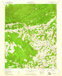
1959 Map of Trout Dale
USGS Topo · Published 1960About this map
Iron Mountain and Pine Mountain dominate this corner of the Jefferson National Forest during the late 1950s. The terrain is defined by the Tennessee Divide and a series of high peaks including Third Peak, Second Peak, and First Peak. Small mountain communities like Trout Dale and Volney sit along the valleys, connected by the Buchanan Highway and proximity to rural centers like Grant. The map documents a sparse but established network of family landmarks and local institutions, featuring numerous cemeteries such as Blevins Cem and Hoffman Cem, alongside country churches like Fox Creek Ch and Little Wilson Ch.
Find a feature on this map
82 named features on this map. Tap any name to fly to it.
Don’t see what you’re looking for? This feature index may not catch every label — zoom into the map to look around manually.
Map Details
Editions of this 1959 Trout Dale Map
4 editions found
Other maps of this area

1889 · Wytheville
USGS Topo · 1:125,000

1891 · Abingdon
USGS Topo · 1:125,000

1892 · Wytheville
USGS Topo · 1:125,000

1894 · Abingdon
USGS Topo · 1:125,000

1909 · Abingdon
USGS Topo · 1:96,000

1911 · Abingdon
USGS Topo · 1:125,000

1931 · Rural Retreat
USGS Topo · 1:48,000

1935 · Mouth of Wilson
USGS Topo · 1:48,000

1935 · Park
USGS Topo · 1:24,000

1935 · Mount Rogers
USGS Topo · 1:48,000