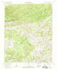
1959 Map of Trout Dale
USGS Topo · Published 1969About this map
Trout Dale and the surrounding mountain ridges of Jefferson National Forest define this 1959 survey of the Smyth and Grayson county border. The landscape is marked by the rugged heights of Pine Mountain and Straight Mountain, with the Appalachian Trail winding through the western terrain near Fairwood. Settlement patterns follow the winding course of Fox Creek, where local life centered around small rural nodes like Grant and Volney. Genealogists will find a high density of family-named landmarks and community sites, including Comers Creek Ch, Friendship Ch, and numerous burial grounds such as Blevins Cem and Fairwood Cem. The map captures a moment before modern development, showing the original routes of the Buchanan Highway and Highway 16 as they navigate the steep gaps between Bobbys Ridge and Iron Mountain.
Find a feature on this map
90 named features on this map. Tap any name to fly to it.
Don’t see what you’re looking for? This feature index may not catch every label — zoom into the map to look around manually.
Map Details
Editions of this 1959 Trout Dale Map
4 editions found
Other maps of this area

1889 · Wytheville
USGS Topo · 1:125,000

1891 · Abingdon
USGS Topo · 1:125,000

1892 · Wytheville
USGS Topo · 1:125,000

1894 · Abingdon
USGS Topo · 1:125,000

1909 · Abingdon
USGS Topo · 1:96,000

1911 · Abingdon
USGS Topo · 1:125,000

1931 · Rural Retreat
USGS Topo · 1:48,000

1935 · Mouth of Wilson
USGS Topo · 1:48,000

1935 · Park
USGS Topo · 1:24,000

1935 · Mount Rogers
USGS Topo · 1:48,000