1960s Maps of Greensville County, Virginia
Explore 14 historic maps of Greensville County from the 1960s. These maps offer a rare glimpse into what life looked like during the 1960s — showing old roads, neighborhoods, homes, and landmarks that have changed or disappeared over time.
Whether you're researching your family's past, planning a metal detecting trip, or studying how Greensville County's landscape evolved across the 1960s, these high-resolution maps are a powerful tool for exploring the history of this region.
- Focus on a specific era: All maps on this page are from the 1960s, giving you a focused view of this time period.
- See what’s changed: Compare century-old streets, trails, and buildings to today's modern landscape using overlays and satellite layers.
- Research with precision: Use these maps for genealogy, historical research, land use analysis, or educational projects.
- View, download, or print: Maps are fully viewable online in high resolution, and can be downloaded or printed for your own records.
Start exploring Greensville County's history through authentic maps from the 1960s. This is your window into the past.
Greensville County, VA maps
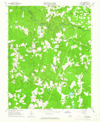
(14)- 1963 Map of Skippers, 1964 Print
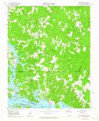
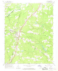
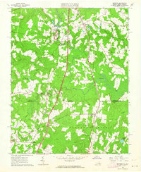 1963 Skippers1964 Print · USGSGreensville County, Virginia, and Northampton County, North Carolina, appear here in the early sixties as the interstate era began to reach the border. Researchers can find numerous family-named landmarks and rural hubs, from Wyche Cem and Robinson Cem to the local centers at Skippers and Dahlia.3 unique versions available
 - 1963 Map of Barley, 1964 Print
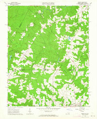 1963 Barley1964 Print · USGSCross the state line between Virginia and North Carolina in the early sixties, where rural life centered on small crossroads like Barley. Genealogists can locate family-named sites like Garners Mill, Royland Sch, and Oak Grove Ch.3 unique versions available
 - 1963 Map of Mc Kenney, 1964 Print
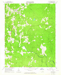 1963 Mc Kenney1964 Print · USGSDinwiddie County's rural landscape is centered on the railroad town of McKenney in the early 1960s, a time when family-named cemeteries and country churches defined the community. Local history researchers can trace family roots at Asbury Cem, Abernathy Cem, or near the Nottoway River and Cutbank Bridge.2 unique versions available
 - 1963 Map of Cherry Hill, 1964 Print
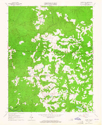 1963 Cherry Hill1964 Print · USGSDinwiddie and Sussex counties come alive in the early 1960s, showing a traditional landscape of crossroads stores and family holdings. Genealogists can locate numerous family burial sites like Boisseau Cem and Bain Cem or centers of community life at Wharf's Store and Masontown Sch.3 unique versions available
 - 1963 Map of Purdy, 1964 Print
 1963 Purdy1964 Print · USGSGreensville and Sussex counties are captured here in the early sixties, showing a landscape of river-bottom swamps and rural railroad hamlets. Genealogists can trace family landmarks like Cowie Cem, Coyie Corner, and several country churches including St Johns Ch.3 unique versions available
 - 1963 Map of Smoky Ordinary, 1964 Print
 1963 Smoky Ordinary1964 Print · USGSSouthern Brunswick County appears in the early sixties as a region of small rail stops and country parishes. Genealogists and historians can trace family locations near Smoky Ordinary, Mallory Sch, or the several churches like Emmanuel Ch along the NORFOLK AND WESTERN line.3 unique versions available
 - 1963 Map of Emporia, 1964 Print
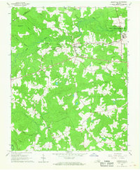
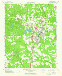 1963 Emporia1964 Print · USGSGreensville County at the dawn of the 1960s reveals a bustling rail crossroads centered on Emporia. Researchers can trace the development of local institutions like the Greensville Memorial Hospital and locate family landmarks such as Jones Cemetery and Round Hill Cemetery.5 unique versions available
 - 1963 Map of Ante, 1964 Print
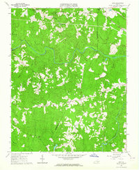 1963 Ante1964 Print · USGSBrunswick and Greensville counties in the early sixties remained a landscape of rural crossroads and river bottomlands. Genealogists can locate family landmarks like Hobbs Chapel, the Scott Lewis Sch, and small hamlets such as Totaro and Cordie.3 unique versions available
 - 1963 Map of Valentines, 1964 Print
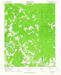
 1963 Valentines1964 Print · USGSThe Virginia and North Carolina borderlands are captured in the early sixties as the reservoirs of Lake Gaston and Roanoke Rapids Lake shape the landscape. Researchers can trace rural community life through sites like Little Bethel Ch, Vultare, and the Old Railroad Grade.4 unique versions available
 - 1966 Map of Drewryville, 1968 Print
 1966 Drewryville1968 Print · USGSSouthampton County during the mid-sixties reveals a landscape of rural crossroads and timbered wetlands tied together by the Norfolk and Western railway. Researchers can trace local heritage through landmarks like Persons Ch, Hebron Ch, and the brick Kilns near the eastern border.2 unique versions available
 - 1966 Map of Margarettsville, 1968 Print
 1966 Margarettsville1968 Print · USGSThe Virginia and North Carolina borderlands come alive in the 1960s, showing a landscape defined by the winding Meherrin River and the Seaboard Coast Line railroad. Researchers can trace rural life through landmarks like Margarettsville, Rising Star Ch, and the Southampton Speedway.4 unique versions available
 - 1966 Map of Adams Grove, 1968 Print
 1966 Adams Grove1968 Print · USGSSouthampton and Greensville Counties are captured here in the mid-sixties, showing a landscape defined by meandering river bends and timber-linked rail lines. Genealogists and historians can trace rural landmarks from Grizzard to Adams Grove, including Pleasant Grove Cem and the Meherrin River.3 unique versions available
 - 1966 Map of Jarratt, 1968 Print
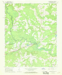
 1966 Jarratt1968 Print · USGSThe rail junction at Jarratt and the surrounding swamps of Southside Virginia are captured here in the mid-sixties. Genealogists and local historians can trace family locations near Jefferson Sch or rural landmarks like Harrells Mill and Bethlehem Ch.4 unique versions available
 - 1966 Map of Claresville, 1968 Print
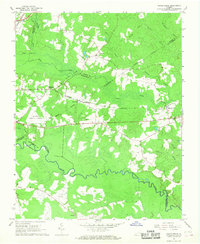
 1966 Claresville1968 Print · USGSThe Virginia and North Carolina borderlands come into focus in the late 1960s, showing a landscape of timbered swamps and isolated farmsteads. Researchers can trace old family sites near Turners Crossroads, Morris Hill Ch, and the waters of Taylors Millpond.3 unique versions available
End of results
Showing maps 1-14 of 14
Frequently asked questions
- What are the different types of historical maps available for Greensville County?
- What is the oldest map of Greensville County?
- Where can I purchase historical maps of Greensville County for my home or office?
- Where can I download high-res historical maps of Greensville County?
- Are there historical topographic maps available for Greensville County?
- Is there historical aerial imagery available for Greensville County?
- Where are historical maps of Greensville County sourced from?