1940s Maps of Bassett, Virginia
Explore 2 historic maps of Bassett from the 1940s. These maps offer a rare glimpse into what life looked like during the 1940s — showing old roads, neighborhoods, homes, and landmarks that have changed or disappeared over time.
Whether you're researching your family's past, planning a metal detecting trip, or studying how Bassett's landscape evolved across the 1940s, these high-resolution maps are a powerful tool for exploring the history of this region.
- Focus on a specific era: All maps on this page are from the 1940s, giving you a focused view of this time period.
- See what’s changed: Compare century-old streets, trails, and buildings to today's modern landscape using overlays and satellite layers.
- Research with precision: Use these maps for genealogy, historical research, land use analysis, or educational projects.
- View, download, or print: Maps are fully viewable online in high resolution, and can be downloaded or printed for your own records.
Start exploring Bassett's history through authentic maps from the 1940s. This is your window into the past.
Bassett, VA maps
(2)- 1944 Map of Martinsville
 1944 Martinsville1944 Print · USGSHenry County is captured in the mid-1940s as a thriving center of industry and agriculture along the Smith River. Genealogists and historians can trace family locations near dozens of rural landmarks like Rough and Ready Mill, Cedar Chappell, and the County Farm.
 - 1944 Map of Rocky Mount
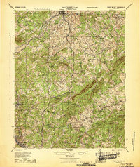 1944 Rocky Mount1944 Print · USGSFranklin County's rural heartland is meticulously detailed in the 1940s, showing the early industrial growth of Bassett and the rail-connected hub of Rocky Mount. Genealogists can trace family landmarks and community centers like Cassell Cem, Pigg River Sch, and Ramsays Store.
End of results
Showing maps 1-2 of 2
Top cities near Bassett
- Martinsville historical maps
- Collinsville historical maps
- Rocky Mount historical maps
- Stanleytown historical maps
- Henry Fork historical maps
- Fieldale historical maps
See more
Frequently asked questions
- What are the different types of historical maps available for Bassett?
- What is the oldest map of Bassett?
- Where can I purchase historical maps of Bassett for my home or office?
- Where can I download high-res historical maps of Bassett?
- Are there historical topographic maps available for Bassett?
- Is there historical aerial imagery available for Bassett?
- Where are historical maps of Bassett sourced from?