1940s Maps of Unison, Virginia
Explore 4 historic maps of Unison from the 1940s. These maps offer a rare glimpse into what life looked like during the 1940s — showing old roads, neighborhoods, homes, and landmarks that have changed or disappeared over time.
Whether you're researching your family's past, planning a metal detecting trip, or studying how Unison's landscape evolved across the 1940s, these high-resolution maps are a powerful tool for exploring the history of this region.
- Focus on a specific era: All maps on this page are from the 1940s, giving you a focused view of this time period.
- See what’s changed: Compare century-old streets, trails, and buildings to today's modern landscape using overlays and satellite layers.
- Research with precision: Use these maps for genealogy, historical research, land use analysis, or educational projects.
- View, download, or print: Maps are fully viewable online in high resolution, and can be downloaded or printed for your own records.
Start exploring Unison's history through authentic maps from the 1940s. This is your window into the past.
Unison, VA maps
(4)- 1943 Map of Bluemont, 1960 Print
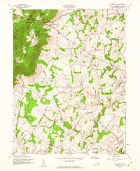 1943 Bluemont1960 Print · USGSLoudoun County’s rural heritage is preserved here in the 1940s, showing the ridge-and-valley landscape before modern development. Genealogists can trace family roots through settlements like Unison and Willisville, and landmarks like Ebenezer Ch.
 - 1944 Map of Bluemont
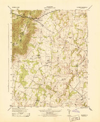 1944 Bluemont1944 Print · USGSLoudoun County is shown in the mid-1940s as a landscape of mountain gaps and established rural hamlets. Genealogists and researchers can trace the locations of Pine Grove School, Ebenezer Church, and the winding Appalachian Trail.
 - 1944 Map of Berryville
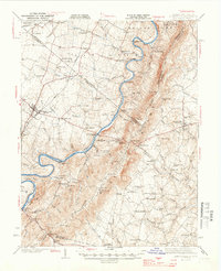 1944 Berryville1944 Print · USGSThe Virginia and West Virginia borderlands are captured here in the mid-1940s, showing the agricultural valley around Berryville meeting the steep Blue Ridge. Researchers can trace the path of the Appalachian Trail or locate vanished landmarks like Boyds Ferry and the Yellow Schoolhouse.
 - 1948 Map of Baltimore
 1948 Baltimore1948 Print · USGSMaryland and Pennsylvania crossroads are captured in the late 1940s, showing a landscape defined by historic rail lines and major military installations. Genealogists can trace family connections in Gettysburg, Westminster, and near the U.S. Naval Academy in Annapolis.2 unique versions available
End of results
Showing maps 1-4 of 4
Top cities near Unison
- Leesburg historical maps
- Gainesville historical maps
- Stone Ridge historical maps
- Purcellville historical maps
- Charles Town historical maps
- Berryville historical maps
See more
Frequently asked questions
- What are the different types of historical maps available for Unison?
- What is the oldest map of Unison?
- Where can I purchase historical maps of Unison for my home or office?
- Where can I download high-res historical maps of Unison?
- Are there historical topographic maps available for Unison?
- Is there historical aerial imagery available for Unison?
- Where are historical maps of Unison sourced from?