1960s Maps of Madison, Virginia
Explore 2 historic maps of Madison from the 1960s. These maps offer a rare glimpse into what life looked like during the 1960s — showing old roads, neighborhoods, homes, and landmarks that have changed or disappeared over time.
Whether you're researching your family's past, planning a metal detecting trip, or studying how Madison's landscape evolved across the 1960s, these high-resolution maps are a powerful tool for exploring the history of this region.
- Focus on a specific era: All maps on this page are from the 1960s, giving you a focused view of this time period.
- See what’s changed: Compare century-old streets, trails, and buildings to today's modern landscape using overlays and satellite layers.
- Research with precision: Use these maps for genealogy, historical research, land use analysis, or educational projects.
- View, download, or print: Maps are fully viewable online in high resolution, and can be downloaded or printed for your own records.
Start exploring Madison's history through authentic maps from the 1960s. This is your window into the past.
Madison, VA maps
(2)- 1964 Map of Rochelle, 1966 Print
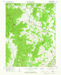
 1964 Rochelle1966 Print · USGSIn the foothills of the Blue Ridge during the mid-sixties, this area shows a network of established crossroads communities and mountain ridges. Trace the location of family landmarks and local institutions like Repton Mills, Pleasant Grove Ch, and Dawsonville.4 unique versions available
 - 1964 Map of Madison, 1966 Print
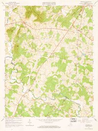
 1964 Madison1966 Print · USGSVirginia's Blue Ridge foothills are captured in the mid-sixties, from the protected wilderness of Shenandoah National Park to the streets of Madison. Trace rural family roots near Graves Chapel, Criglersville, and Cedar Hill Cem.5 unique versions available
End of results
Showing maps 1-2 of 2
Top cities near Madison
- Hollymead historical maps
- Orange historical maps
- Piney Mountain historical maps
- Twin Lakes historical maps
- Ruckersville historical maps
- Brightwood historical maps
See more
Frequently asked questions
- What are the different types of historical maps available for Madison?
- What is the oldest map of Madison?
- Where can I purchase historical maps of Madison for my home or office?
- Where can I download high-res historical maps of Madison?
- Are there historical topographic maps available for Madison?
- Is there historical aerial imagery available for Madison?
- Where are historical maps of Madison sourced from?