1960s Maps of Mathews County, Virginia
Explore 9 historic maps of Mathews County from the 1960s. These maps offer a rare glimpse into what life looked like during the 1960s — showing old roads, neighborhoods, homes, and landmarks that have changed or disappeared over time.
Whether you're researching your family's past, planning a metal detecting trip, or studying how Mathews County's landscape evolved across the 1960s, these high-resolution maps are a powerful tool for exploring the history of this region.
- Focus on a specific era: All maps on this page are from the 1960s, giving you a focused view of this time period.
- See what’s changed: Compare century-old streets, trails, and buildings to today's modern landscape using overlays and satellite layers.
- Research with precision: Use these maps for genealogy, historical research, land use analysis, or educational projects.
- View, download, or print: Maps are fully viewable online in high resolution, and can be downloaded or printed for your own records.
Start exploring Mathews County's history through authentic maps from the 1960s. This is your window into the past.
Mathews County, VA maps
(9)- 1964 Map of Richmond
 1964 Richmond1964 Print · USGSCoastal and central Virginia are mapped during the mid-twentieth century, showing the critical intersection of rail, river, and military life. Genealogists can trace family roots through rural county seats like Amelia or find vanished coastal neighborhoods near Phoebus and Hilton Village.
 - 1964 Map of Deltaville, 1966 Print
 1964 Deltaville1966 Print · USGSThe Middlesex County coastline in the mid-sixties reveals a landscape defined by its relation to the Chesapeake. Genealogists and historians can trace family locations near Deltaville, find local landmarks like Philippi Ch, or locate old landings at Stingray Point and Westland.4 unique versions available
 - 1964 Map of New Point Comfort, 1966 Print
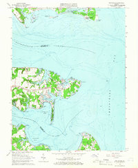
 1964 New Point Comfort1966 Print · USGSThe coastal peninsula of Mathews County comes alive in this mid-century survey of the Chesapeake shoreline. Trace the family landmarks of Potato Neck and discover the location of the New Point Sch and the New Point Comfort Lighthouse.2 unique versions available
 - 1964 Map of Wilton, 1966 Print
 1964 Wilton1966 Print · USGSThe Virginia Middle Peninsula in the mid-1960s reveals a tidewater landscape of small settlements and riverfront landings. Genealogists and historians can locate rural landmarks such as Old Brick Ch, Stampers Wharf Sch, and Barricks Millpond.4 unique versions available
 - 1964 Map of East of New Point Comfort, 1987 Print
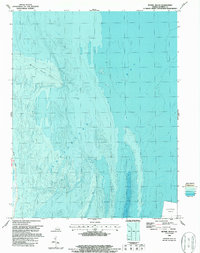
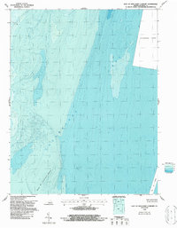 1964 East of New Point Comfort1987 Print · USGSCoastal Mathews County waters are captured during the mid-1960s, focusing on the maritime approaches and seafloor of the Chesapeake Bay. Researchers can trace the depth contours of New Pt Comfort Shoal and the critical York Spit Channel.
 - 1965 Map of Ware Neck, 1966 Print
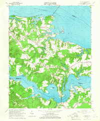
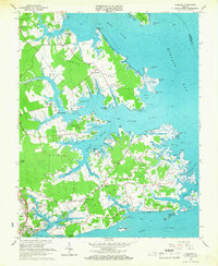
 1965 Ware Neck1966 Print · USGSCoastal Gloucester and Mathews Counties are shown in the mid-1960s, documenting a landscape of tidal necks and maritime landings. Researchers can trace historic river access points and local landmarks like Auburn Wharf, Fort Nonsense, and Baileys Wharf Beacon.4 unique versions available
 - 1965 Map of Achilles, 1967 Print
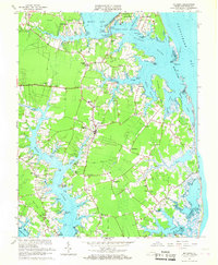
 1965 Achilles1967 Print · USGSCoastal Virginia in the mid-1960s is preserved here as a landscape of tidal creeks and maritime landings. Trace the roots of local families at Roanes Wharf, Achilles, and historic sites like First Morning Star Ch.3 unique versions available
 - 1965 Map of Mathews, 1967 Print
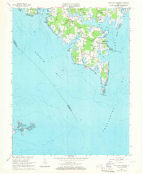
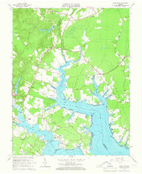
 1965 Mathews1967 Print · USGSCoastal Mathews County during the mid-sixties reveals a peninsula shaped by tide and tradition, from the shores of Gwynn Island to the Mobjack waterfront. Researchers can trace family-named landmarks and community centers like Williams Wharf, Mathews Raceway, and Smither Memorial Cem.3 unique versions available
 - 1965 Map of Bethel Beach, 1987 Print
 1965 Bethel Beach1987 Print · USGSThe Mathews County shoreline meets the Chesapeake Bay in this mid-century maritime survey. Researchers can trace the precise contours of Bethel Beach and Winter Harbor alongside historical Light locations and bathymetric depths.
End of results
Showing maps 1-9 of 9
Top cities of Mathews County
Frequently asked questions
- What are the different types of historical maps available for Mathews County?
- What is the oldest map of Mathews County?
- Where can I purchase historical maps of Mathews County for my home or office?
- Where can I download high-res historical maps of Mathews County?
- Are there historical topographic maps available for Mathews County?
- Is there historical aerial imagery available for Mathews County?
- Where are historical maps of Mathews County sourced from?