1970s Maps of Mecklenburg County, Virginia
Explore 5 historic maps of Mecklenburg County from the 1970s. These maps offer a rare glimpse into what life looked like during the 1970s — showing old roads, neighborhoods, homes, and landmarks that have changed or disappeared over time.
Whether you're researching your family's past, planning a metal detecting trip, or studying how Mecklenburg County's landscape evolved across the 1970s, these high-resolution maps are a powerful tool for exploring the history of this region.
- Focus on a specific era: All maps on this page are from the 1970s, giving you a focused view of this time period.
- See what’s changed: Compare century-old streets, trails, and buildings to today's modern landscape using overlays and satellite layers.
- Research with precision: Use these maps for genealogy, historical research, land use analysis, or educational projects.
- View, download, or print: Maps are fully viewable online in high resolution, and can be downloaded or printed for your own records.
Start exploring Mecklenburg County's history through authentic maps from the 1970s. This is your window into the past.
Mecklenburg County, VA maps
(5)- 1977 Map of Tungsten, 1978 Print
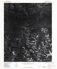 1977 Tungsten1978 Print · USGSThe shorelines of Vance County are captured in detail in the late seventies as the reservoir waters reach deep into the timberland. Researchers can trace the exact footprint of the settlement at Tungsten and follow the inlets of Island Creek.
 - 1977 Map of John H Kerr Dam, 1978 Print
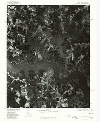
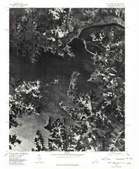 1977 John H Kerr Dam1978 Print · USGSThe Mecklenburg County borderlands appear in high-contrast aerial detail during the late seventies, showing the managed waters of the John H Kerr Reservoir. Researchers can trace the sprawling shoreline and rural tracts near Rose Hill and the massive John H Kerr Dam.
 - 1977 Map of Bracey, 1979 Print
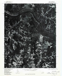 1977 Bracey1979 Print · USGSThe Roanoke River valley and the Virginia-North Carolina borderlands are seen here in the late seventies. Researchers can trace the sprawling shoreline of Lake Gaston and locate regional crossroads like Bracey and Palmer Springs.
 - 1977 Map of Clarksville South, 1979 Print
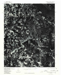 1977 Clarksville South1979 Print · USGSMecklenburg County and the Virginia-North Carolina border are captured during the late seventies, showing the landscape dominated by the reservoir. Trace the rural layout of Buffalo Junction and the shoreline near Shiny Rock.
 - 1977 Map of South Hill SE, 1979 Print
 1977 South Hill SE1979 Print · USGSMecklenburg County and the borderlands of North Carolina come into focus in the late seventies as the shoreline of Lake Gaston reshapes the land. Researchers can trace the development of lakeside tracts near Joyceville and the rural road junctions at Five Forks.
End of results
Showing maps 1-5 of 5
Top cities of Mecklenburg County
- South Hill historical maps
- Chase City historical maps
- Bracey historical maps
- Clarksville historical maps
- La Crosse historical maps
- Boydton historical maps
See more
Frequently asked questions
- What are the different types of historical maps available for Mecklenburg County?
- What is the oldest map of Mecklenburg County?
- Where can I purchase historical maps of Mecklenburg County for my home or office?
- Where can I download high-res historical maps of Mecklenburg County?
- Are there historical topographic maps available for Mecklenburg County?
- Is there historical aerial imagery available for Mecklenburg County?
- Where are historical maps of Mecklenburg County sourced from?