1900s (20th Century) Maps of Orange, Virginia
Explore 11 historic maps of Orange from the 1900s (20th Century). These maps offer a rare glimpse into what life looked like during the 1900s — showing old roads, neighborhoods, homes, and landmarks that have changed or disappeared over time.
Whether you're researching your family's past, planning a metal detecting trip, or studying how Orange's landscape evolved across the 1900s, these high-resolution maps are a powerful tool for exploring the history of this region.
- Focus on a specific era: All maps on this page are from the 1900s, giving you a focused view of this time period.
- See what’s changed: Compare century-old streets, trails, and buildings to today's modern landscape using overlays and satellite layers.
- Research with precision: Use these maps for genealogy, historical research, land use analysis, or educational projects.
- View, download, or print: Maps are fully viewable online in high resolution, and can be downloaded or printed for your own records.
Start exploring Orange's history through authentic maps from the 1900s. This is your window into the past.
Orange, VA maps
(11)- 1949 Map of Charlottesville
 1949 Charlottesville1949 Print · USGSThe Shenandoah Valley and Blue Ridge appear in the late 1940s as a thriving corridor of rail and river commerce. Researchers can trace the mid-century footprints of Harrisonburg, Staunton, and Culpeper alongside the historic routes of the Southern Railway.2 unique versions available
 - 1956 Map of Charlottesville, 1966 Print
 1956 Charlottesville1966 Print · USGSThe Shenandoah Valley and Blue Ridge are captured in detail during the mid-1960s as the modern interstate system began to emerge. Genealogists and historians can trace rail-connected hubs like Waynesboro or follow the river paths of the Rapidan River and Rivanna River.4 unique versions available
 - 1961 Map of Gordonsville, 1962 Print
 1961 Gordonsville1962 Print · USGSCentral Virginia in the early sixties remains a landscape of deep historical roots and rail-based commerce. Genealogists and researchers can trace family names through landmarks like Boswells Tavern, the James Madison Grave, and rural sites like Liberty Mills.2 unique versions available
 - 1961 Map of Rapidan, 1963 Print
 1961 Rapidan1963 Print · USGSMadison and Culpeper Counties during the early sixties show a transition from a traditional mill-based economy to a modern rural landscape. Genealogists can trace family names at Waylands Mill, Achsah, and Thorofare Mtn Chapel along the Piedmont rivers.2 unique versions available
 - 1970 Map of Orange, 1972 Print
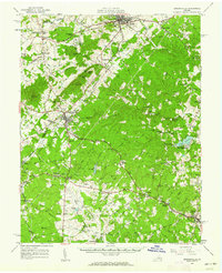
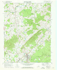
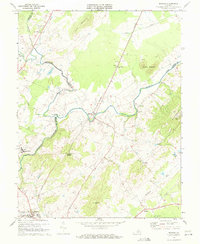
 1970 Orange1972 Print · USGSOrange and its surrounding Piedmont countryside are captured in the early seventies as a rail-centered community. Genealogists can locate family landmarks like Pierces Shop, Vawter Corner, and historic congregations at Shady Grove Ch.3 unique versions available
 - 1970 Map of Gordonsville, 1972 Print
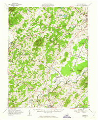
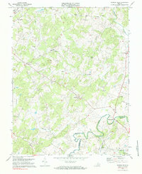
 1970 Gordonsville1972 Print · USGSGordonsville and the surrounding Virginia Piedmont are captured here in the early seventies as a vital rail crossroads. Researchers can trace family history through sites like James Madison Sch, Blue Run Ch, and the many cemeteries near Old Somerset.3 unique versions available
 - 1971 Map of Rapidan, 1972 Print
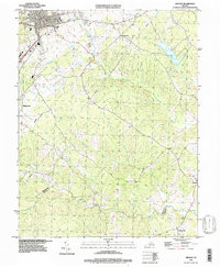
 1971 Rapidan1972 Print · USGSOrange and Culpeper Counties meet at the river forks in the early 1970s, showing a landscape defined by the Southern rail line and traditional rural crossroads. Researchers can locate local landmarks like Woodberry Forest Sch, Emmanuel Ch, and the quarries near Buzzard Mountain.2 unique versions available
 - 1971 Map of Madison Mills, 1984 Print
 1971 Madison Mills1984 Print · USGSMadison and Orange Counties are captured in the early 1970s along the winding banks of the Rapidan River. Genealogists and local historians can trace rural roots through landmarks like Prices Shop, Twymans Mill, and the Grymes Sch.2 unique versions available
 - 1977 Map of Gordonsville, 1982 Print
 1977 Gordonsville1982 Print · USGSGordonsville and the surrounding Virginia Piedmont appear in sharp detail during the late seventies, showing the area's rural character and rail-town roots. Researchers can trace land tracts near Gordonsville and Somerset or locate family sites along Blue Run.
 - 1986 Map of Charlottesville
 1986 Charlottesville1986 Print · USGSCentral Virginia in the mid-eighties shows a landscape balanced between the growing city centers of the Piedmont and the protected ridges of the Blue Ridge. Trace the historic rail lines of the Chesapeake and Ohio Railway or locate local landmarks like Monticello Mountain and Bridgewater College.3 unique versions available
 - 1994 Map of Orange, 1997 Print
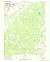
 1994 Orange1997 Print · USGSThe town of Orange and its surrounding rural crossroads are captured here in the mid-1990s as the regional landscape transitioned into the modern era. Genealogists and local historians can trace family locations near Pierces Shop, Daniel, and Vawter Corner.
End of results
Showing maps 1-11 of 11
Top cities near Orange
- Culpeper historical maps
- Louisa historical maps
- Gordonsville historical maps
- Brightwood historical maps
- Blue Ridge Shores historical maps
- Madison historical maps
See more
Top neighborhoods of Orange
Frequently asked questions
- What are the different types of historical maps available for Orange?
- What is the oldest map of Orange?
- Where can I purchase historical maps of Orange for my home or office?
- Where can I download high-res historical maps of Orange?
- Are there historical topographic maps available for Orange?
- Is there historical aerial imagery available for Orange?
- Where are historical maps of Orange sourced from?