1900s (20th Century) Maps of Page County, Virginia
Explore 43 historic maps of Page County from the 1900s (20th Century). These maps offer a rare glimpse into what life looked like during the 1900s — showing old roads, neighborhoods, homes, and landmarks that have changed or disappeared over time.
Whether you're researching your family's past, planning a metal detecting trip, or studying how Page County's landscape evolved across the 1900s, these high-resolution maps are a powerful tool for exploring the history of this region.
- Focus on a specific era: All maps on this page are from the 1900s, giving you a focused view of this time period.
- See what’s changed: Compare century-old streets, trails, and buildings to today's modern landscape using overlays and satellite layers.
- Research with precision: Use these maps for genealogy, historical research, land use analysis, or educational projects.
- View, download, or print: Maps are fully viewable online in high resolution, and can be downloaded or printed for your own records.
Start exploring Page County's history through authentic maps from the 1900s. This is your window into the past.
Page County, VA maps
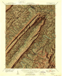
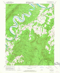
(43)- 1905 Map of Luray, 1910 Print
 1905 Luray1910 Print · USGSThe Blue Ridge and Shenandoah Valley are frozen in time just after the turn of the century, showing the critical rail networks and mountain gaps of the period. Genealogists can trace family names and settlements like Luray, Front Royal, and Strasburg along the Shenandoah Valley Railroad.4 unique versions available
 - 1929 Map of Stony Man
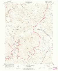
 1929 Stony Man1929 Print · USGSBlue Ridge mountain life and the early development of Shenandoah National Park are captured here just as the park boundary was being established. Genealogists and hikers can trace old mountain routes to the President Hoover Community Sch, locate St Luke Episcopal Mission, or find early trail markers at Sexton Shelter.2 unique versions available
 - 1930 Map of Madison
 1930 Madison1930 Print · USGSThe Blue Ridge foothills of Madison and Greene counties are captured here just as Shenandoah National Park was being established. Researchers can trace the early mountain communities around Graves Mill, Criglersville, and the remote Upper Pocosin Mission.3 unique versions available
 - 1933 Map of Stony Man
 1933 Stony Man1933 Print · USGSThe Blue Ridge highlands and Page Valley are captured here during the early years of the national park era. Genealogists and historians can trace family locations through mountain hollows and riverside crossings like Stricklers Ferry, St George Mission, and Baileys Store.3 unique versions available
 - 1933 Map of Madison
 1933 Madison1933 Print · USGSThe Virginia Piedmont meets the Blue Ridge in the early thirties, just as the national park is taking shape. Genealogists can trace family names across Eppards Mill, The Presidents Camp, and remote schools like the Upper Pocosin Mission.3 unique versions available
 - 1937 Map of Elkton
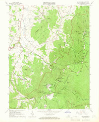
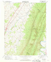
 1937 Elkton1937 Print · USGSThe Shenandoah Valley and Blue Ridge highlands are captured here in the 1930s as mountain missions and rural schools still served remote hollows. Genealogists can locate family landmarks like the Wyatt Shiflett Ch, Simmons Gap PO, and Blose Sch.3 unique versions available
 - 1942 Map of Mt Jackson, 1959 Print
 1942 Mt Jackson1959 Print · USGSThe Shenandoah Valley during the early forties reveals a landscape defined by the towering Massanutten Mountain and the winding river forks. Researchers can trace historic industrial sites like Catherine Furnace, old schools such as Soliloquy Sch, and the grounds of Shenandoah Academy.2 unique versions available
 - 1946 Map of Mt Jackson
 1946 Mt Jackson1946 Print · USGSThe Shenandoah Valley during the mid-1940s reveals a landscape defined by the parallel forks of its famous river and the rising wall of Massanutten Mountain. Genealogists can trace family lines through sites like Riedlers Sch, Catherine Furnace, and Long Cem.2 unique versions available
 - 1947 Map of Mt Jackson
 1947 Mt Jackson1947 Print · USGSThe Shenandoah Valley during the 1940s is captured here, showing the dramatic ridges between the river forks. Genealogists and historians can trace community roots through sites like Woods Chapel, Plains Mill, and Shenandoah Academy near New Market.2 unique versions available
 - 1947 Map of Strasburg, 1955 Print
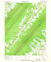
 1947 Strasburg1955 Print · USGSThe Shenandoah Valley during the late 1940s reveals a landscape defined by the winding North and South Forks of the river and the steep ridges of Massanutten. Genealogists can locate rural landmarks like Saint Davids Church, Bentonville, and the Mt Hebron Ch Cem.7 unique versions available
 - 1949 Map of Charlottesville
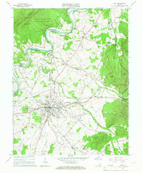
 1949 Charlottesville1949 Print · USGSThe Shenandoah Valley and Blue Ridge appear in the late 1940s as a thriving corridor of rail and river commerce. Researchers can trace the mid-century footprints of Harrisonburg, Staunton, and Culpeper alongside the historic routes of the Southern Railway.2 unique versions available
 - 1950 Map of Strasburg
 1950 Strasburg1950 Print · USGSThe northern Shenandoah Valley is shown just after the war, defined by the winding forks of the river and the massive ridges of Massanutten Mountain. Genealogists and historians can trace family sites at Mt Hebron Cemetery, Goode Mill, and the mountain-bound community of Seven Fountains.2 unique versions available
 - 1956 Map of Charlottesville, 1966 Print
 1956 Charlottesville1966 Print · USGSThe Shenandoah Valley and Blue Ridge are captured in detail during the mid-1960s as the modern interstate system began to emerge. Genealogists and historians can trace rail-connected hubs like Waynesboro or follow the river paths of the Rapidan River and Rivanna River.4 unique versions available
 - 1965 Map of Big Meadows, 1966 Print
 1965 Big Meadows1966 Print · USGSThe high ridges of Page County meet the valley floor during the mid-1960s, showing the early infrastructure of the National Park. Genealogists and hikers can trace the original routes of the Appalachian Trail and find family landmarks like Trinity Ch, Bethlehem Ch, and Tanners Ridge.4 unique versions available
 - 1965 Map of Thornton Gap, 1966 Print
 1965 Thornton Gap1966 Print · USGSShenandoah National Park and the Blue Ridge heights are captured here in the mid-sixties as recreation and mountain life intersected. Researchers can trace the winding Skyline Drive, locate the Morning Star Church, and find old shelters like Byrds Nest No 3.5 unique versions available
 - 1965 Map of Elkton West, 1966 Print
 1965 Elkton West1966 Print · USGSThe Shenandoah Valley in the mid-sixties shows a landscape of steep mountain ridges and river-town commerce. Researchers can trace the heritage of McGaheysville and Elkton alongside the Chesapeake Western Railway and sites like East Point Cem.4 unique versions available
 - 1965 Map of Old Rag Mtn, 1966 Print
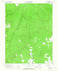
 1965 Old Rag Mtn1966 Print · USGSShenandoah National Park and the eastern Blue Ridge foothills come to life in the mid-1960s. Researchers can locate the historic Corbin Cabin, trace the original route of the APPALACHIAN TRAIL, and explore the rural road networks of Etlan and Nethers.6 unique versions available
 - 1965 Map of Luray, 1966 Print
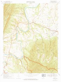
 1965 Luray1966 Print · USGSPage County in the mid-sixties is captured here between the heights of the Blue Ridge and the Massanutten range. Genealogists and local historians can trace the valley's settlement patterns through numerous rural landmarks like Beahms Chapel, Antioch Ch, and the streets of Luray.3 unique versions available
 - 1965 Map of Elkton East, 1967 Print
 1965 Elkton East1967 Print · USGSThe Shenandoah Valley and Blue Ridge highlands meet in the 1960s, showing a landscape of river-side towns and mountain hollows. Genealogists can trace family roots at Naylor Cem or Mt Paran Ch, and follow the rails of the Norfolk and Western.3 unique versions available
 - 1965 Map of Fletcher, 1967 Print
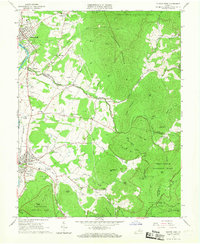
 1965 Fletcher1967 Print · USGSMadison and Greene Counties are shown in the mid-sixties as the mountain communities of the Blue Ridge foothills intersected with the developing Shenandoah National Park. Researchers can locate family landmarks like the Fletcher Cem, Shiloh Ch, and the presidential retreat at Rapidan Camp.4 unique versions available
 - 1966 Map of Bentonville, 1968 Print
 1966 Bentonville1968 Print · USGSThe Shenandoah River valley at the mid-century reveals a landscape framed by national parks and the river's great loops. Genealogists and hikers can trace the original paths of the Appalachian Trail near Bentonville, find old riverside communities like Overall, and locate rural landmarks such as Mt Carmel Ch.4 unique versions available
 - 1966 Map of Rileyville, 1968 Print
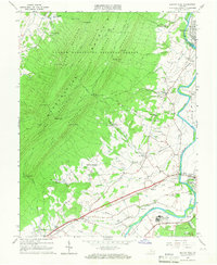
 1966 Rileyville1968 Print · USGSThe Shenandoah Valley during the mid-sixties reveals a landscape of ridge-top lookouts and river-bottom agriculture. Researchers can locate family landmarks like Fosters Landing, Saint Davids Church, and the Norfolk and Western rail line.4 unique versions available
 - 1967 Map of Stanley, 1969 Print
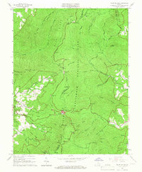
 1967 Stanley1969 Print · USGSPage County is documented in the late sixties as the river-and-rail economy of the Page Valley thrived. Genealogists and local historians can trace family locations near Alma, St Lukes Ch, and the old Grove Hill Landing on the river.2 unique versions available
 - 1967 Map of Hamburg, 1969 Print
 1967 Hamburg1969 Print · USGSThe river valley and mountain ridges of Page County come into focus during the late sixties. Genealogists and researchers can trace the historic river landings and rural churches including Whitehouse Landing, Woods Chapel, and the Mill Creek Ch.3 unique versions available
 - 1967 Map of Tenth Legion, 1970 Print
 1967 Tenth Legion1970 Print · USGSThe Shenandoah Valley and the formidable slopes of Massanutten Mountain are frozen in time here during the late sixties. Genealogists and local historians can trace small communities like Arkton and Athlone or locate the Bethlehem Ch and various family cemeteries.2 unique versions available
Showing maps 1-25 of 43
Top cities of Page County
Frequently asked questions
- What are the different types of historical maps available for Page County?
- What is the oldest map of Page County?
- Where can I purchase historical maps of Page County for my home or office?
- Where can I download high-res historical maps of Page County?
- Are there historical topographic maps available for Page County?
- Is there historical aerial imagery available for Page County?
- Where are historical maps of Page County sourced from?