1990s Maps of Page County, Virginia
Explore 12 historic maps of Page County from the 1990s. These maps offer a rare glimpse into what life looked like during the 1990s — showing old roads, neighborhoods, homes, and landmarks that have changed or disappeared over time.
Whether you're researching your family's past, planning a metal detecting trip, or studying how Page County's landscape evolved across the 1990s, these high-resolution maps are a powerful tool for exploring the history of this region.
- Focus on a specific era: All maps on this page are from the 1990s, giving you a focused view of this time period.
- See what’s changed: Compare century-old streets, trails, and buildings to today's modern landscape using overlays and satellite layers.
- Research with precision: Use these maps for genealogy, historical research, land use analysis, or educational projects.
- View, download, or print: Maps are fully viewable online in high resolution, and can be downloaded or printed for your own records.
Start exploring Page County's history through authentic maps from the 1990s. This is your window into the past.
Page County, VA maps
(12)- 1994 Map of Big Meadows, 1997 Print
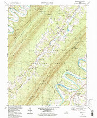
 1994 Big Meadows1997 Print · USGSThe high peaks and hollows of the Blue Ridge define this mid-1990s view of the Shenandoah wilderness and the adjacent Page County lowlands. Researchers can trace historic mountain sites like Skyland, Big Meadows, and the Appalachian Trail alongside valley landmarks such as Longs Store and Hawksbill Ch.
 - 1994 Map of Tenth Legion, 1997 Print
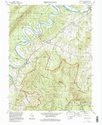
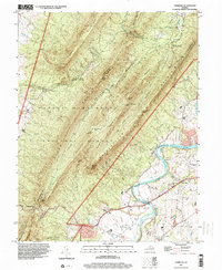
 1994 Tenth Legion1997 Print · USGSShenandoah Valley life in the mid-1990s is captured here, where farmland meets the wooded slopes of the George Washington National Forest. Genealogists and historians can locate rural landmarks like Bethlehem Ch, the site of Endless Caverns, and a historic Covered Bridge.
 - 1994 Map of Thornton Gap, 1997 Print
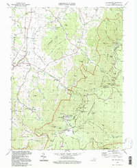
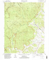
 1994 Thornton Gap1997 Print · USGSThe high crest of the Blue Ridge is captured here in the 1990s as it divides Page and Rappahannock Counties. Hikers and historians can trace the Appalachian Trail past Pass Mountain Shelter or locate the park facilities at Panorama.
 - 1994 Map of Luray, 1997 Print
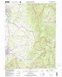
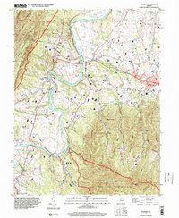
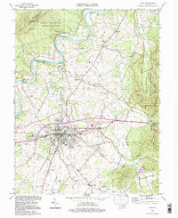 1994 Luray1997 Print · USGSPage County is seen here during the mid-nineties as the town of Luray sits between the expansive Shenandoah National Park and Massanutten Mountain. Researchers can trace the path of the Norfolk and Western railroad or locate landmarks like Luray Caverns and Evergreen Cem.
 - 1994 Map of Rileyville, 1997 Print
 1994 Rileyville1997 Print · USGSShenandoah and Page Counties are shown in the mid-1990s, where the Shenandoah River loops around the ridges of Massanutten Mountain. Researchers can locate ancestral sites like Rileyville, Goods Mill, and rural congregations at Saint Davids Church or White Chapel.
 - 1994 Map of Bentonville, 1997 Print
 1994 Bentonville1997 Print · USGSThe South Fork Shenandoah Valley in the mid-1990s remains a landscape defined by its river bends and mountain ridges. Genealogists and hikers can trace river landings like Bentonville Landing, small settlements such as Overall, and the paths of the Appalachian Trail or Skyline Drive.
 - 1994 Map of Old Rag Mountain, 1997 Print
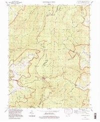
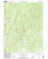
 1994 Old Rag Mountain1997 Print · USGSThe Madison County highlands are captured here in the mid-1990s, where high wilderness peaks meet rural valley life. Genealogists and hikers can trace historical sites like Corbin Cabin, the Bethlehem Ch, and the rugged course of the Hughes River.
 - 1997 Map of Elkton East, 1999 Print
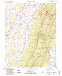
 1997 Elkton East1999 Print · USGSThe Shenandoah Valley meets the Blue Ridge in the late twentieth century, showing a mix of mountain wilderness and river-town life. Trace family sites at Naylor Cem, old routes near Furnace, and springs like Bear Lithia Spring.
 - 1997 Map of Stanley, 2000 Print
 1997 Stanley2000 Print · USGSThe South Fork Shenandoah River valley in the late nineties shows a landscape defined by riverside settlements and mountain ridges. Genealogists can trace family landmarks like Longs Cem or locate rural congregations at St Pauls Ch and Leake Chapel.
 - 1997 Map of Hamburg, 2000 Print
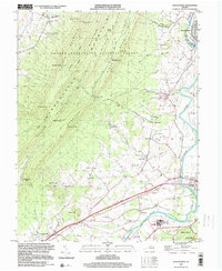
 1997 Hamburg2000 Print · USGSPage County and the ridges of the Massanutten are captured here in the late nineties, showing a landscape defined by river bends and mountain gaps. Genealogists and local historians can trace family sites near Hamburg, Leaksville, and Whitehouse Landing along the river.
 - 1999 Map of Elkton West, 2000 Print
 1999 Elkton West2000 Print · USGSThe Shenandoah Valley comes alive in the late 1990s as the river winds past the Massanutten ridges. Researchers can trace local heritage through landmarks like McGaheysville, the East Point Cem, and the mid-century Drive-in Theater at Solsburg.
 - 1999 Map of Fletcher, 2000 Print
 1999 Fletcher2000 Print · USGSThe Blue Ridge highlands meet the rural settlements of Madison County in the late 1990s as the wilderness of Shenandoah transitions to mountain valleys. Genealogists and hikers can trace the Appalachian Trail past historic sites like Fletcher, Shiloh Ch, and the Lower Pocosin Mission.
End of results
Showing maps 1-12 of 12
Top cities of Page County
Frequently asked questions
- What are the different types of historical maps available for Page County?
- What is the oldest map of Page County?
- Where can I purchase historical maps of Page County for my home or office?
- Where can I download high-res historical maps of Page County?
- Are there historical topographic maps available for Page County?
- Is there historical aerial imagery available for Page County?
- Where are historical maps of Page County sourced from?