1960s Maps of Luray, Virginia
Explore 2 historic maps of Luray from the 1960s. These maps offer a rare glimpse into what life looked like during the 1960s — showing old roads, neighborhoods, homes, and landmarks that have changed or disappeared over time.
Whether you're researching your family's past, planning a metal detecting trip, or studying how Luray's landscape evolved across the 1960s, these high-resolution maps are a powerful tool for exploring the history of this region.
- Focus on a specific era: All maps on this page are from the 1960s, giving you a focused view of this time period.
- See what’s changed: Compare century-old streets, trails, and buildings to today's modern landscape using overlays and satellite layers.
- Research with precision: Use these maps for genealogy, historical research, land use analysis, or educational projects.
- View, download, or print: Maps are fully viewable online in high resolution, and can be downloaded or printed for your own records.
Start exploring Luray's history through authentic maps from the 1960s. This is your window into the past.
Luray, VA maps
(2)- 1965 Map of Luray, 1966 Print
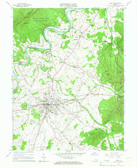 1965 Luray1966 Print · USGSPage County in the mid-sixties is captured here between the heights of the Blue Ridge and the Massanutten range. Genealogists and local historians can trace the valley's settlement patterns through numerous rural landmarks like Beahms Chapel, Antioch Ch, and the streets of Luray.3 unique versions available
 - 1967 Map of Hamburg, 1969 Print
 1967 Hamburg1969 Print · USGSThe river valley and mountain ridges of Page County come into focus during the late sixties. Genealogists and researchers can trace the historic river landings and rural churches including Whitehouse Landing, Woods Chapel, and the Mill Creek Ch.3 unique versions available
End of results
Showing maps 1-2 of 2
Top cities near Luray
- Woodstock historical maps
- Shenandoah historical maps
- New Market historical maps
- Mount Jackson historical maps
- Stanley historical maps
- Edinburg historical maps
See more
Top neighborhoods of Luray
- Spring View historical maps
- Westlu historical maps
- Fairview historical maps
- Brookside historical maps
- Forest Hills historical maps
- Hilldale historical maps
See more
Frequently asked questions
- What are the different types of historical maps available for Luray?
- What is the oldest map of Luray?
- Where can I purchase historical maps of Luray for my home or office?
- Where can I download high-res historical maps of Luray?
- Are there historical topographic maps available for Luray?
- Is there historical aerial imagery available for Luray?
- Where are historical maps of Luray sourced from?