1970s Maps of Patrick County, Virginia
Explore 3 historic maps of Patrick County from the 1970s. These maps offer a rare glimpse into what life looked like during the 1970s — showing old roads, neighborhoods, homes, and landmarks that have changed or disappeared over time.
Whether you're researching your family's past, planning a metal detecting trip, or studying how Patrick County's landscape evolved across the 1970s, these high-resolution maps are a powerful tool for exploring the history of this region.
- Focus on a specific era: All maps on this page are from the 1970s, giving you a focused view of this time period.
- See what’s changed: Compare century-old streets, trails, and buildings to today's modern landscape using overlays and satellite layers.
- Research with precision: Use these maps for genealogy, historical research, land use analysis, or educational projects.
- View, download, or print: Maps are fully viewable online in high resolution, and can be downloaded or printed for your own records.
Start exploring Patrick County's history through authentic maps from the 1970s. This is your window into the past.
Patrick County, VA maps
(3)- 1976 Map of Cana, 1979 Print
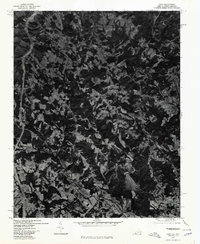 1976 Cana1979 Print · USGSThe Virginia-North Carolina border country comes into view in this mid-1970s aerial study of Carroll County and its neighbors. Genealogists and local historians can trace the exact field lines and road networks surrounding Cana, Toast, and Pine Ridge.
 - 1976 Map of Mount Airy North, 1979 Print
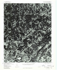 1976 Mount Airy North1979 Print · USGSThe foothills of Surry County appear in photographic detail during the 1970s, centered on the northern edge of the Blue Ridge gateway. Trace the residential growth near Mount Airy and Toast or locate family home sites in Ararat and Flat Rock.
 - 1977 Map of Philpott Lake, 1983 Print
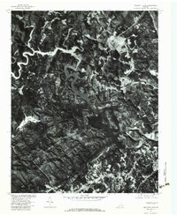 1977 Philpott Lake1983 Print · USGSFranklin County's landscape in the late seventies is captured here through aerial photography, showing the region's wooded ridges and deep waters. Trace the winding shores of Philpott Lake and locate old crossroads near Prilliman and Philpott.
End of results
Showing maps 1-3 of 3
Top cities of Patrick County
Frequently asked questions
- What are the different types of historical maps available for Patrick County?
- What is the oldest map of Patrick County?
- Where can I purchase historical maps of Patrick County for my home or office?
- Where can I download high-res historical maps of Patrick County?
- Are there historical topographic maps available for Patrick County?
- Is there historical aerial imagery available for Patrick County?
- Where are historical maps of Patrick County sourced from?