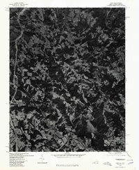
1976 Map of Cana
USGS Topo · Published 1979About this map
Cana anchors this mid-1970s orthophotoquad, which covers the borderlands where Virginia and North Carolina meet. Unlike traditional topographic maps, this aerial imagery provides a direct visual record of land use, revealing the dense patchwork of agricultural clearings and forested ridges that define the Carroll County landscape. To the south, the settlement of Toast and the small community of Pine Ridge sit amidst a network of rural roads, while the winding course of Stewarts Creek cuts through the terrain. The imagery highlights the contrast between the lower valley fields and the rising prominence of local elevations like Sugarloaf and Wheeler Knob. This specific format captures the exact footprint of homesteads and orchards as they existed during the Bicentennial era, offering a precise look at the rural infrastructure before late-century development.
Find a feature on this map
6 named features on this map. Tap any name to fly to it.
Don’t see what you’re looking for? This feature index may not catch every label — zoom into the map to look around manually.
Map Details
Editions of this 1976 Cana Map
This is the sole edition of this map. No revisions or reprints were ever made.
Other maps of this area

1889 · Hillsville
USGS Topo · 1:125,000

1891 · Yadkinville
USGS Topo · 1:125,000

1892 · Hillsville
USGS Topo · 1:125,000

1893 · Yadkinville
USGS Topo · 1:125,000

1896 · Hillsville
USGS Topo · 1:125,000

1931 · Galax
USGS Topo · 1:48,000

1933 · Galax
USGS Topo · 1:62,500

1953 · Winston-Salem
USGS Topo · 1:250,000

1955 · Winston-Salem
USGS Topo · 1:250,000

1957 · Mount Airy
USGS Topo · 1:62,500