1960s Maps of Belona, Virginia
Explore 3 historic maps of Belona from the 1960s. These maps offer a rare glimpse into what life looked like during the 1960s — showing old roads, neighborhoods, homes, and landmarks that have changed or disappeared over time.
Whether you're researching your family's past, planning a metal detecting trip, or studying how Belona's landscape evolved across the 1960s, these high-resolution maps are a powerful tool for exploring the history of this region.
- Focus on a specific era: All maps on this page are from the 1960s, giving you a focused view of this time period.
- See what’s changed: Compare century-old streets, trails, and buildings to today's modern landscape using overlays and satellite layers.
- Research with precision: Use these maps for genealogy, historical research, land use analysis, or educational projects.
- View, download, or print: Maps are fully viewable online in high resolution, and can be downloaded or printed for your own records.
Start exploring Belona's history through authentic maps from the 1960s. This is your window into the past.
Belona, VA maps
(3)- 1960 Map of Lakeside Village, 1962 Print
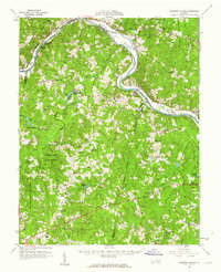 1960 Lakeside Village1962 Print · USGSThe James River and the Chesapeake and Ohio railroad shaped the Cumberland and Goochland borderlands during the early 1960s. Genealogists can trace family names and social centers through landmarks like Flippen Millpond, Little Fork Ch, and Muddy Creek Cem.2 unique versions available
 - 1963 Map of Roanoke
 1963 Roanoke1963 Print · USGSCentral Virginia and the Blue Ridge front appear here in the early sixties, caught between their deep railroad roots and new postwar developments. Genealogists and historians can trace the rail lines of the Norfolk and Western through towns like Bedford and Altavista, or locate family landmarks near Smith Mountain Lake.
 - 1969 Map of Trenholm, 1971 Print
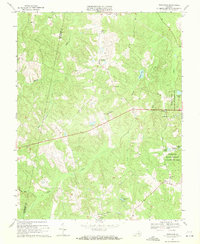 1969 Trenholm1971 Print · USGSPowhatan and Cumberland counties in the late sixties remain a landscape of quiet crossroads and traditional community centers. Genealogists and local historians can locate old family landmarks like Providence Cem and historic meeting houses such as Mt Pero Ch and Muddy Creek Ch.3 unique versions available
End of results
Showing maps 1-3 of 3
Top cities near Belona
Frequently asked questions
- What are the different types of historical maps available for Belona?
- What is the oldest map of Belona?
- Where can I purchase historical maps of Belona for my home or office?
- Where can I download high-res historical maps of Belona?
- Are there historical topographic maps available for Belona?
- Is there historical aerial imagery available for Belona?
- Where are historical maps of Belona sourced from?