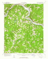
1960 Map of Lakeside Village
USGS Topo · Published 1962About this map
The James River corridor defines this landscape, where the Chesapeake and Ohio railroad tracks follow the northern bank through historic crossings like Cartersville and Pemberton. A massive island, Elk Island, splits the river flow, while to the south, the expansive Cumberland State Forest dominates the interior terrain. This area reflects a quiet mid-century rural economy shaped by water and timber, with numerous local landmarks such as Lakeside Village and the State Game Farm providing social and administrative anchors.
Find a feature on this map
80 named features on this map. Tap any name to fly to it.
Don’t see what you’re looking for? This feature index may not catch every label — zoom into the map to look around manually.
Map Details
Editions of this 1960 Lakeside Village Map
2 editions found
Other maps of this area

1890 · Goochland
USGS Topo · 1:125,000

1891 · Palmyra
USGS Topo · 1:125,000

1891 · Farmville
USGS Topo · 1:125,000

1892 · Goochland
USGS Topo · 1:125,000

1893 · Farmville
USGS Topo · 1:125,000

1895 · Palmyra
USGS Topo · 1:125,000

1897 · Amelia
USGS Topo · 1:125,000

1897 · Palmyra
USGS Topo · 1:125,000

1943 · Goochland
USGS Topo · 1:31,680

1943 · Powhatan
USGS Topo · 1:31,680