1990s Maps of Prince George County, Virginia
Explore 6 historic maps of Prince George County from the 1990s. These maps offer a rare glimpse into what life looked like during the 1990s — showing old roads, neighborhoods, homes, and landmarks that have changed or disappeared over time.
Whether you're researching your family's past, planning a metal detecting trip, or studying how Prince George County's landscape evolved across the 1990s, these high-resolution maps are a powerful tool for exploring the history of this region.
- Focus on a specific era: All maps on this page are from the 1990s, giving you a focused view of this time period.
- See what’s changed: Compare century-old streets, trails, and buildings to today's modern landscape using overlays and satellite layers.
- Research with precision: Use these maps for genealogy, historical research, land use analysis, or educational projects.
- View, download, or print: Maps are fully viewable online in high resolution, and can be downloaded or printed for your own records.
Start exploring Prince George County's history through authentic maps from the 1990s. This is your window into the past.
Prince George County, VA maps
(6)- 1990 Map of Emporia
 1990 Emporia1990 Print · USGSThe Southside Virginia borderlands are captured here in the late twentieth century, showing the critical rail and river networks of the region. Genealogists and local historians can trace family roots through rural communities like Alberta, Boykins, and Dolphin along the Meherrin River.
 - 1994 Map of Hopewell, 1996 Print
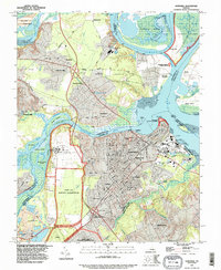 1994 Hopewell1996 Print · USGSCoastal Virginia during the 1990s shows a dense intersection of military, industrial, and historical sites at the river forks. Genealogists and historians can trace family locations in Screamersville, locate the National Cem, and explore the grounds of Bermuda Hundred.
 - 1994 Map of Prince George, 1996 Print
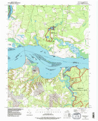
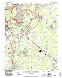 1994 Prince George1996 Print · USGSThe Petersburg area in the mid-nineties shows the convergence of military history and modern development. Researchers can trace the bounds of the Petersburg National Battlefield, find the small settlement of New Bohemia, and locate Southlawn Memorial Park (Cem).
 - 1994 Map of Petersburg, 1996 Print
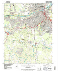 1994 Petersburg1996 Print · USGSPetersburg and its neighbors show a landscape of deep military history and river-based industry in the mid-nineties. Trace civil war fortifications from Petersburg Nat Battlefield to Fort Wadsworth alongside the sprawling Blandford Cemetery.
 - 1994 Map of Chester, 1996 Print
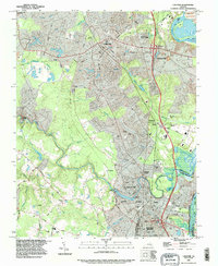 1994 Chester1996 Print · USGSChesterfield County during the mid-nineties shows the suburban expansion between Chester and Colonial Heights as modern infrastructure met historical river bends. Researchers can locate family sites at Sunset Memorial Park Cemetery or trace the old rail lines through Lynch Siding and Walthall.
 - 1994 Map of Westover, 1996 Print
 1994 Westover1996 Print · USGSThe James River shoreline in Charles City County remained a landscape of historic plantations and wildlife sanctuaries during the 1990s. Genealogists and local historians can trace family-named sites and landmarks like Berkeley, Rolands Mill, and Harrisons Landing.
End of results
Showing maps 1-6 of 6
Top cities of Prince George County
Frequently asked questions
- What are the different types of historical maps available for Prince George County?
- What is the oldest map of Prince George County?
- Where can I purchase historical maps of Prince George County for my home or office?
- Where can I download high-res historical maps of Prince George County?
- Are there historical topographic maps available for Prince George County?
- Is there historical aerial imagery available for Prince George County?
- Where are historical maps of Prince George County sourced from?