Old Maps of Prince George County, Virginia for Metal Detecting
Plan your next treasure hunt with 86 historic maps of Prince George County. Find old homesites, ghost towns, trails, and gathering spots that may be lost to time — perfect for identifying promising metal detecting locations.
- Locate forgotten sites: Uncover places like long-lost settlements, abandoned rail lines, or gathering spots.
- Plan better hunts: Use map overlays combined with LiDAR or satellite views to narrow in on historically rich areas.
- Made for detectorists: Thousands of hobbyists use these maps to discover relics, coins, and hidden history.
Use these historic maps to boost your research and find new opportunities beneath the surface of Prince George County.
Prince George County, VA maps
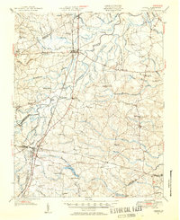
(86)- 1894 Map of Bermuda Hundred
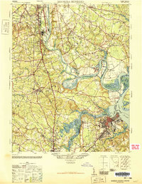
 1894 Bermuda Hundred1894 Print · USGSBermuda Hundred and the James River winding toward the Chesapeake are captured here in the late nineteenth century. Researchers can trace the legacy of the Civil War through Drewry Bluff, Malvern Hill, and the engineering of the Dutch Gap Canal.5 unique versions available
 - 1894 Map of Petersburg
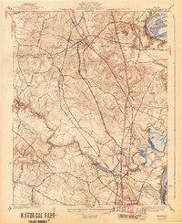
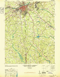
 1894 Petersburg1894 Print · USGSPetersburg and its riverfront neighbors are captured here in the 1890s, when the Appomattox valley was a bustling hub of rail and mill industry. Genealogists can trace family-named sites across the countryside, from Youngblood's Store to Rowland's Mill and Poplar Spring Ch.6 unique versions available
 - 1917 Map of Toano, 1959 Print
 1917 Toano1959 Print · USGSCoastal Virginia during the early twentieth century shows a landscape where rail lines and steamboat routes intersect. Genealogists can trace family roots through numerous sites like Hickory Neck Church, One Eye School, and Barrets Ferry.
 - 1918 Map of Charles City
 1918 Charles City1918 Print · USGSCoastal Virginia at the end of the Great War reveals a landscape of riverfront wharves and rural schoolhouses. Genealogists can trace family roots through sites like the Samaria Indian School, Parish Hill Church, and Harrisons Landing.4 unique versions available
 - 1918 Map of Toano
 1918 Toano1918 Print · USGSThe Virginia Peninsula comes alive in the years following the Great War, showing a landscape of river landings and rail-side villages. Researchers can trace the path of the Chesapeake and Ohio through Toano or locate early rural schoolhouses like One Eye School and Brickbat School.3 unique versions available
 - 1919 Map of Jarratt
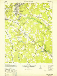
 1919 Jarratt1919 Print · USGSSoutheastern Virginia at the close of the Great War was a busy crossroads of the Atlantic Coast Line and Virginian railroads. Genealogists and local historians can trace family locations near the Russian Church, identify the site of Harrells Mill, or locate old post offices like Comans Well.3 unique versions available
 - 1919 Map of Surry
 1919 Surry1919 Print · USGSSurry County and the James River tidewater are captured in the late teens, when timber and steamboats still drove the local economy. Researchers can locate vanished landmarks like Spratleys Mill, the Old Courthouse, and numerous schoolhouses including Rough School and Cypress School.3 unique versions available
 - 1919 Map of Disputanta
 1919 Disputanta1919 Print · USGSCoastal Virginia during the late teens is characterized by a landscape of tidal creeks and rail-connected agricultural towns. Genealogists can locate family landmarks like Sycamore Church, Star Hill School, and the scattered hamlets of Newville and Garysville.3 unique versions available
 - 1943 Map of Savedge
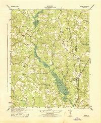
 1943 Savedge1943 Print · USGSSurry and Prince George Counties appear here during the Second World War as a landscape of timber mills and tidal creeks. Genealogists can locate family landmarks like the Lone Oak Grist Mill, Burrowsville, and Gravel Hill Church.
 - 1943 Map of Hopewell
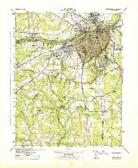
 1943 Hopewell1943 Print · USGSMid-century Hopewell and the historic James River peninsula come to life in this wartime survey of the river-and-rail hub. Genealogists and historians can trace family locations near Bermuda Hundred, the military grounds at Camp Lee, and local landmarks like Enon Ch.3 unique versions available
 - 1943 Map of Disputanta
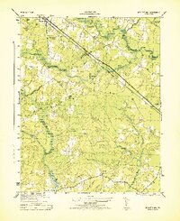
 1943 Disputanta1943 Print · USGSPrince George County is shown in the early 1940s as a landscape of timber-rich swamps and rural crossroads. Local historians can trace family locations near Seldons Store, Old Academy School, and the National Moorish Home.
 - 1943 Map of Richmond, 1972 Print
 1943 Richmond1972 Print · USGSCoastal Virginia and the state capital are shown in detail during the mid-century era of infrastructure expansion. Genealogists and historians can trace the grounds of Richmond Nat Battlefield Park, locate the Yorktown Nat Cem, or follow the many rural routes through Amelia Court House and Tappahannock.
 - 1944 Map of Reams
 1944 Reams1944 Print · USGSMid-century Dinwiddie County comes into focus in this wartime survey of the rural communities south of Petersburg. Genealogists and historians can trace family roots through several local landmarks like Oak Grove Church, Zion School, and the village of Rowanta.
 - 1944 Map of Chester
 1944 Chester1944 Print · USGSChesterfield County during the early years of the Second World War shows a landscape balancing its deep rail history with new aviation and highway developments. Genealogists can locate family landmarks like Shiloh Ch, the old Port Walthall Sch, and settlements at Pickadat Corner and Dunlop.2 unique versions available
 - 1944 Map of Petersburg
 1944 Petersburg1944 Print · USGSPetersburg and the surrounding Dinwiddie County countryside are shown here during the 1940s, revealing a landscape deeply intertwined with its Civil War history and rail industry. Researchers can locate family landmarks like Sharon Church, trace the lines of the Atlantic Coast Line, or study the grounds of Poplar Grove National Cemetery.2 unique versions available
 - 1944 Map of Nebletts Mill
 1944 Nebletts Mill1944 Print · USGSCoastal plain wetlands and small rail-side settlements define this part of Sussex County during the mid-forties. Genealogists and local historians can trace the rural landscape surrounding Disputanta, the grounds of Newville Church, and the waters of Nebletts Mill Pond.
 - 1946 Map of Bermuda Hundred
 1946 Bermuda Hundred1946 Print · USGSThe James River corridor south of Richmond is shown here just after the war, where industrial hubs like Hopewell meet colonial-era landscapes. Genealogists and historians can trace the foundations of Bermuda Hundred, the grounds of Camp Lee, and landmarks like Shirley or Drewrys Bluff.2 unique versions available
 - 1946 Map of Petersburg
 1946 Petersburg1946 Print · USGSPetersburg and the surrounding tobacco and rail country of the mid-1940s are documented here just as the post-war era began. Genealogists and historians can trace family locations near Blandford Cemetery, search for rural schoolhouses like Bives School, or locate the historic river crossing at Pocahontas Island.3 unique versions available
 - 1947 Map of Nebletts Mills
 1947 Nebletts Mills1947 Print · USGSCoastal Virginia during the late 1940s reveals a landscape of dense swamps and vital rail corridors connecting rural communities. Genealogists and local historians can trace the foundations of Disputanta and Newville, or locate landmarks like Cinema Church and Nebletts Millpond.
 - 1949 Map of Petersburg
 1949 Petersburg1949 Print · USGSPetersburg and its industrial riverfront are captured here in the late Forties, showing a city deeply tied to its rail lines and Civil War heritage. Genealogists can locate family landmarks like Sharon Church and Smith Grove Church or trace the grounds of Blandford Cemetery.
 - 1949 Map of Richmond, 1951 Print
 1949 Richmond1951 Print · USGSCoastal Virginia in the years following World War II remained a landscape of historic river towns and expanding military bases. Genealogists and historians can trace the rail lines of the Southern Ry and locate established landmarks from Camp Lee to the remote reaches of Dragon Swamp.
 - 1951 Map of Jarratt, 1952 Print
 1951 Jarratt1952 Print · USGSThe rural Virginia landscape of Sussex and Greensville counties is shown here in the early 1950s, centered on the railroad crossing at Jarratt. Genealogists and historians can trace family locations near landmarks like Winfields Mill, Peagram Cem, and the old Fort Nottoway.2 unique versions available
 - 1952 Map of Prince George
 1952 Prince George1952 Print · USGSPrince George County is captured here in the early postwar years, revealing a landscape defined by military expansion and traditional rural settlements. Genealogists and historians can trace family locations near St Pauls Church, the village of New Bohemia, or the grounds of Rives School.2 unique versions available
 - 1952 Map of Lees Mill Pond
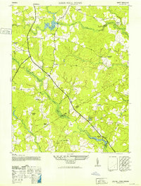 1952 Lees Mill Pond1952 Print · USGSCoastal plain lowlands along the Prince George and Sussex border come to life in this mid-century survey. Researchers can trace the layout of small crossroads communities and family landmarks like Templeton, the Hakks School, and the local Grist Mill.2 unique versions available
 - 1952 Map of Brandon, 1957 Print
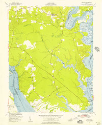 1952 Brandon1957 Print · USGSCharles City County and the James River shoreline are captured here in the early fifties, showing a landscape of riverfront landings and historic tidewater tracts. Researchers can locate Liberty Cem, the rural church at Mt Zion Ch, and old industrial sites like the Brick Kilns.
Showing maps 1-25 of 86
Top cities of Prince George County
Frequently asked questions
- What are the different types of historical maps available for Prince George County?
- What is the oldest map of Prince George County?
- Where can I purchase historical maps of Prince George County for my home or office?
- Where can I download high-res historical maps of Prince George County?
- Are there historical topographic maps available for Prince George County?
- Is there historical aerial imagery available for Prince George County?
- Where are historical maps of Prince George County sourced from?