1950s Maps of Prince George County, Virginia
Explore 18 historic maps of Prince George County from the 1950s. These maps offer a rare glimpse into what life looked like during the 1950s — showing old roads, neighborhoods, homes, and landmarks that have changed or disappeared over time.
Whether you're researching your family's past, planning a metal detecting trip, or studying how Prince George County's landscape evolved across the 1950s, these high-resolution maps are a powerful tool for exploring the history of this region.
- Focus on a specific era: All maps on this page are from the 1950s, giving you a focused view of this time period.
- See what’s changed: Compare century-old streets, trails, and buildings to today's modern landscape using overlays and satellite layers.
- Research with precision: Use these maps for genealogy, historical research, land use analysis, or educational projects.
- View, download, or print: Maps are fully viewable online in high resolution, and can be downloaded or printed for your own records.
Start exploring Prince George County's history through authentic maps from the 1950s. This is your window into the past.
Prince George County, VA maps
(18)- 1951 Map of Jarratt, 1952 Print
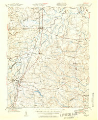 1951 Jarratt1952 Print · USGSThe rural Virginia landscape of Sussex and Greensville counties is shown here in the early 1950s, centered on the railroad crossing at Jarratt. Genealogists and historians can trace family locations near landmarks like Winfields Mill, Peagram Cem, and the old Fort Nottoway.2 unique versions available
 - 1952 Map of Prince George
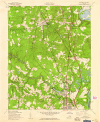
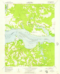
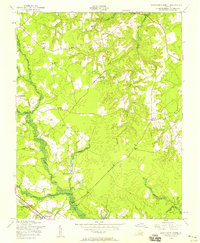
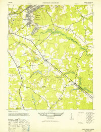 1952 Prince George1952 Print · USGSPrince George County is captured here in the early postwar years, revealing a landscape defined by military expansion and traditional rural settlements. Genealogists and historians can trace family locations near St Pauls Church, the village of New Bohemia, or the grounds of Rives School.2 unique versions available
 - 1952 Map of Lees Mill Pond
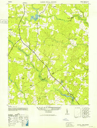 1952 Lees Mill Pond1952 Print · USGSCoastal plain lowlands along the Prince George and Sussex border come to life in this mid-century survey. Researchers can trace the layout of small crossroads communities and family landmarks like Templeton, the Hakks School, and the local Grist Mill.2 unique versions available
 - 1952 Map of Brandon, 1957 Print
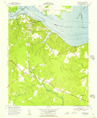
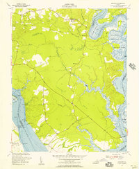 1952 Brandon1957 Print · USGSCharles City County and the James River shoreline are captured here in the early fifties, showing a landscape of riverfront landings and historic tidewater tracts. Researchers can locate Liberty Cem, the rural church at Mt Zion Ch, and old industrial sites like the Brick Kilns.
 - 1952 Map of Chester, 1959 Print
 1952 Chester1959 Print · USGSMid-century Chesterfield County is shown here during a major transit expansion, as turnpikes and interchanges began to reshape the landscape. Local researchers can trace family roots through landmarks like Carver High Sch, Lynch Siding, and the Shiloh Ch.
 - 1952 Map of Petersburg, 1959 Print
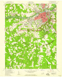 1952 Petersburg1959 Print · USGSPetersburg and its surrounding riverfront communities are shown here during a period of significant postwar transition in the 1950s. You can trace the early path of the Richmond-Petersburg Turnpike as it bypasses historic sites like Fort Lee and Blandford Cemetery.
 - 1952 Map of Hopewell, 1959 Print
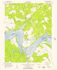
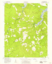
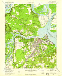 1952 Hopewell1959 Print · USGSThe industrial hub of Hopewell and the grounds of Fort Lee are captured here during the early fifties. Researchers can trace the heritage of the James River through landmarks like Bermuda Hundred, Walthall Mill, and the historic City Point waterfront.
 - 1952 Map of Reams, 1959 Print
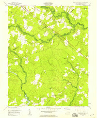
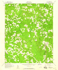 1952 Reams1959 Print · USGSDinwiddie and Prince George counties appear here in the early fifties, centered on the railroad corridor and swampy bottomlands. Genealogists and historians can locate rural landmarks like Rowanta, the Confederate Camp, and old schools such as Reams Sch No 12.
 - 1953 Map of Norfolk, 1954 Print
 1953 Norfolk1954 Print · USGSCoastal Virginia and northeastern North Carolina appear here during the post-war industrial boom, showing the critical rail-and-sea connections of Hampton Roads. Genealogists can trace family roots through rural landmarks like Gethsemane Ch, the Caledonia State Prison Farm, and the vast interior of the Dismal Swamp.4 unique versions available
 - 1953 Map of Westover, 1957 Print
 1953 Westover1957 Print · USGSThe James River shoreline in the early fifties shows a landscape defined by historic estates and riverfront commerce. Researchers can locate Berkeley, the Evelynton Plantation, and rural churches like Merchant Hope Ch.
 - 1953 Map of Charles City, 1957 Print
 1953 Charles City1957 Print · USGSThe James River bends through this mid-century Tidewater landscape, documenting a region of historic estates and riverfront landings. Genealogists and historians can trace the grounds of Flowerdew Hundred, Upper Brandon, and the Sherwood Forest Home of Pres Tyler.
 - 1953 Map of Charles City, 1960 Print
 1953 Charles City1960 Print · USGSCoastal Virginia during the mid-fifties reveals a landscape defined by historic James River plantations and rural crossroads. Genealogists and historians can trace family-named sites from Berkeley and Westover to local landmarks like Ednas Mill and Merchant Hope Ch.2 unique versions available
 - 1954 Map of Claremont, 1957 Print
 1954 Claremont1957 Print · USGSSurry County river life and crossroads farming define this mid-fifties landscape along the James River. Genealogists and local historians can trace the foundations of Claremont, locate the Spring Grove Sch, and find family sites like Debricks Cem.
 - 1956 Map of Lees Mill Pond
 1956 Lees Mill Pond1956 Print · USGSPrince George and Sussex counties are seen here in the mid-fifties, dominated by the intricate wetland networks of the coastal plain. Genealogists and local historians can trace the foundations of rural life at Templeton, Lees Mill, and Salem Church.
 - 1956 Map of Disputanta North, 1958 Print
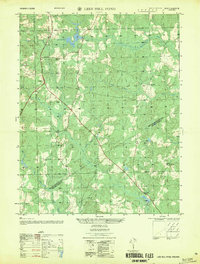
 1956 Disputanta North1958 Print · USGSPrince George County is seen here in the mid-1950s, a landscape of intricate swamplands and rural crossroads. Researchers can trace the Norfolk and Western rail line through Disputanta or locate sites like the National Moorish Home and Old Academy Sch.
 - 1956 Map of Savedge, 1958 Print
 1956 Savedge1958 Print · USGSSurry and Prince George Counties appear here in the mid-fifties, still defined by a network of rural churches and tidal waterways. Researchers can trace the locations of the Lone Oak Grist Mill and settlements like Burrowsville and Barham.
 - 1956 Map of Disputanta South, 1958 Print
 1956 Disputanta South1958 Print · USGSThe coastal plain of Southeast Virginia in the 1950s was a landscape of dense swamps and quiet crossroads where three counties converged. Researchers can trace rural life through the locations of Centerville Ch, Wilburn Sch, and the Norfolk and Western rail line.
 - 1959 Map of Richmond
 1959 Richmond1959 Print · USGSMid-century Virginia is captured here at its most vital rail and river junctions, from the capital city to the Chesapeake Bay. Genealogists and historians can trace the development of colonial settlements like Williamsburg and military landmarks including Fort Monroe and Camp Lee.
End of results
Showing maps 1-18 of 18
Top cities of Prince George County
Frequently asked questions
- What are the different types of historical maps available for Prince George County?
- What is the oldest map of Prince George County?
- Where can I purchase historical maps of Prince George County for my home or office?
- Where can I download high-res historical maps of Prince George County?
- Are there historical topographic maps available for Prince George County?
- Is there historical aerial imagery available for Prince George County?
- Where are historical maps of Prince George County sourced from?