1960s Maps of Prince William County, Virginia
Explore 15 historic maps of Prince William County from the 1960s. These maps offer a rare glimpse into what life looked like during the 1960s — showing old roads, neighborhoods, homes, and landmarks that have changed or disappeared over time.
Whether you're researching your family's past, planning a metal detecting trip, or studying how Prince William County's landscape evolved across the 1960s, these high-resolution maps are a powerful tool for exploring the history of this region.
- Focus on a specific era: All maps on this page are from the 1960s, giving you a focused view of this time period.
- See what’s changed: Compare century-old streets, trails, and buildings to today's modern landscape using overlays and satellite layers.
- Research with precision: Use these maps for genealogy, historical research, land use analysis, or educational projects.
- View, download, or print: Maps are fully viewable online in high resolution, and can be downloaded or printed for your own records.
Start exploring Prince William County's history through authentic maps from the 1960s. This is your window into the past.
Prince William County, VA maps
(15)- 1961 Map of Washington
 1961 Washington1961 Print · USGSThe mid-Atlantic region in the late fifties is presented in remarkable detail, from the Blue Ridge foothills to the Chesapeake Eastern Shore. Researchers can trace historic river landings and military sites like Mount Vernon, Fort Belvoir, and Point Lookout.2 unique versions available
 - 1965 Map of Belvoir, 1967 Print
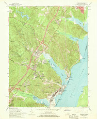
 1965 Belvoir1967 Print · USGSFairfax County in the mid-sixties reveals a dense intersection of Cold War military operations and preserved colonial history along the Potomac shoreline. Researchers can trace ancestral sites at Pohick Ch and Gunston Hall, or locate family homes in Newington and Harbor View.4 unique versions available
 - 1966 Map of Manassas, 1967 Print
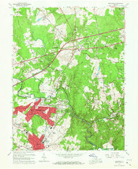 1966 Manassas1967 Print · USGSManassas and Centreville undergo rapid suburban transformation in the mid-sixties as new neighborhoods rise along the Lee Highway. Genealogists and historians can trace the growth of Manassas Park, locate rural sites like State Prison Camp No 30, or follow the Southern Railway through Clifton.4 unique versions available
 - 1966 Map of Occoquan, 1968 Print
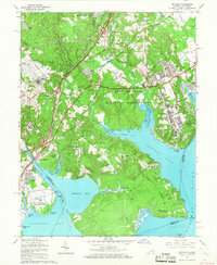
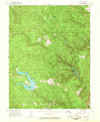
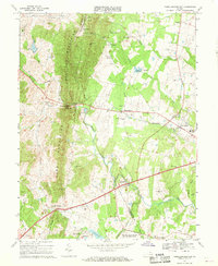
 1966 Occoquan1968 Print · USGSPrince William County is shown in a period of transition during the mid-sixties, as planned communities like Dale City emerge alongside the Occoquan Reservoir. Trace family roots at Oak Grove Ch or locate the site of the former Woodbridge Airport.4 unique versions available
 - 1966 Map of Independent Hill, 1968 Print
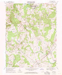
 1966 Independent Hill1968 Print · USGSPrince William County is captured during its mid-century transition, showing the area between the growing Manassas outskirts and the Marine Corps lands. Researchers can locate community anchors like Sacred Heart Cath Ch, the Old Dominion Speedway, and the waters of Lake Jackson.5 unique versions available
 - 1966 Map of Joplin, 1968 Print
 1966 Joplin1968 Print · USGSStafford and Prince William counties are shown in the mid-1960s as the regional landscape was split between military use and conservation. Genealogists and historians can trace old community sites like Joplin and Kopp alongside features like Lunga Reservoir.4 unique versions available
 - 1966 Map of Quantico, 1968 Print
 1966 Quantico1968 Print · USGSCoastal Prince William County is seen here during the mid-sixties, where major military installations meet growing residential villages and thick forest. Researchers can trace the layout of the Quantico Marine Corps Schools or locate local landmarks like Boswells Store and Cockpit Point.6 unique versions available
 - 1966 Map of Indian Head, 1968 Print
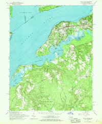 1966 Indian Head1968 Print · USGSMaryland's riverside defense and rural heritage are captured here in the late sixties, centered on the U S Naval Propellant Plant. Genealogists and local historians can trace the U S Government RR through Indian Head or locate family roots near St Marys Ch and Poseys Wharf.6 unique versions available
 - 1966 Map of Somerville, 1969 Print
 1966 Somerville1969 Print · USGSNorthern Virginia's rural landscape meets military expansion in the mid-sixties, capturing a territory defined by small hamlets and training grounds. Genealogists can trace family names at Cromwell Cem and Tacketts Mill, or locate old crossroads like Sowego.4 unique versions available
 - 1966 Map of Thoroughfare Gap, 1969 Print
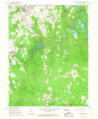
 1966 Thoroughfare Gap1969 Print · USGSPrince William and Fauquier counties are captured here in the mid-1960s as the railroad and highways thread through the Bull Run Mountains. Researchers can locate several rural landmarks including Beverley Mill, the Antioch-McCrae Sch, and the Vint Hill Farms Station Military Reservation.3 unique versions available
 - 1966 Map of Catlett, 1969 Print
 1966 Catlett1969 Print · USGSMid-century Fauquier and Prince William counties are shown here as a landscape of rural crossroads and military installations. Genealogists can trace family roots through numerous country sites like Oak Shade Ch, Balls Mill, and the settlement of Casanova.2 unique versions available
 - 1966 Map of Nokesville, 1969 Print
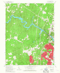
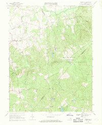
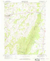
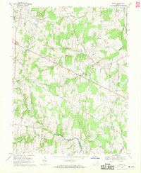
 1966 Nokesville1969 Print · USGSPrince William County in the mid-1960s remained a landscape of rural crossroads and river-fed farmland. Genealogists and local historians can trace the foundations of Nokesville, Brentsville, and Aden, alongside landmarks like Daniels Mill and Valley View Cem.5 unique versions available
 - 1968 Map of Gainesville, 1970 Print
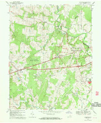 1968 Gainesville1970 Print · USGSGainesville and the surrounding Prince William County countryside are captured here in the late sixties, just as modern infrastructure began to meet the area's deep Civil War legacy. Local historians can locate the Stone Bridge and Dogan House on the battlefield, or trace family landmarks like Mt Calvary Ch and Sudley Springs.6 unique versions available
 - 1968 Map of Middleburg, 1970 Print
 1968 Middleburg1970 Print · USGSNorthern Virginia's equestrian heartland and the rocky ridges of the Bull Run Mountains appear here in the late sixties. Researchers can locate several burial grounds like Sharon Cemetery and historic rural hubs such as Aldie and Halfway.3 unique versions available
 - 1968 Map of Arcola, 1970 Print
 1968 Arcola1970 Print · USGSLoudoun County remains largely rural in the late sixties, just as the influence of the nearby capital begins to expand. Researchers can trace old family sites and transit routes through Arcola, Gilberts Corner, and the historic Braddock Road, or locate Mt Zion Ch and the State Prison Camp No 26.5 unique versions available
End of results
Showing maps 1-15 of 15
Top cities of Prince William County
- Dale City historical maps
- Lake Ridge historical maps
- Woodbridge historical maps
- Linton Hall historical maps
- Cherry Hill historical maps
- Montclair historical maps
See more
Frequently asked questions
- What are the different types of historical maps available for Prince William County?
- What is the oldest map of Prince William County?
- Where can I purchase historical maps of Prince William County for my home or office?
- Where can I download high-res historical maps of Prince William County?
- Are there historical topographic maps available for Prince William County?
- Is there historical aerial imagery available for Prince William County?
- Where are historical maps of Prince William County sourced from?