1970s Maps of Chester Gap, Virginia
Explore 2 historic maps of Chester Gap from the 1970s. These maps offer a rare glimpse into what life looked like during the 1970s — showing old roads, neighborhoods, homes, and landmarks that have changed or disappeared over time.
Whether you're researching your family's past, planning a metal detecting trip, or studying how Chester Gap's landscape evolved across the 1970s, these high-resolution maps are a powerful tool for exploring the history of this region.
- Focus on a specific era: All maps on this page are from the 1970s, giving you a focused view of this time period.
- See what’s changed: Compare century-old streets, trails, and buildings to today's modern landscape using overlays and satellite layers.
- Research with precision: Use these maps for genealogy, historical research, land use analysis, or educational projects.
- View, download, or print: Maps are fully viewable online in high resolution, and can be downloaded or printed for your own records.
Start exploring Chester Gap's history through authentic maps from the 1970s. This is your window into the past.
Chester Gap, VA maps
(2)- 1972 Map of Chester Gap, 1977 Print
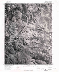 1972 Chester Gap1977 Print · USGSThe Blue Ridge foothills of northern Virginia are captured in this early 1970s aerial survey just as the landscape was beginning a new chapter of growth. Researchers can trace rural property lines and historic road patterns around Browntown and Chester Gap.
 - 1972 Map of Flint Hill, 1977 Print
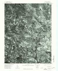 1972 Flint Hill1977 Print · USGSRappahannock and Fauquier counties are captured in the early seventies during a period of steady agricultural tradition. Researchers can trace the layout of historic crossroads settlements like Flint Hill and Hume through detailed aerial orthophotography.
End of results
Showing maps 1-2 of 2
Top cities near Chester Gap
- Front Royal historical maps
- Strasburg historical maps
- Shenandoah Farms historical maps
- Stephens City historical maps
- Middletown historical maps
- Apple Mountain Lake historical maps
See more
Top neighborhoods of Chester Gap
Frequently asked questions
- What are the different types of historical maps available for Chester Gap?
- What is the oldest map of Chester Gap?
- Where can I purchase historical maps of Chester Gap for my home or office?
- Where can I download high-res historical maps of Chester Gap?
- Are there historical topographic maps available for Chester Gap?
- Is there historical aerial imagery available for Chester Gap?
- Where are historical maps of Chester Gap sourced from?