1990s Maps of Sperryville, Virginia
Explore 2 historic maps of Sperryville from the 1990s. These maps offer a rare glimpse into what life looked like during the 1990s — showing old roads, neighborhoods, homes, and landmarks that have changed or disappeared over time.
Whether you're researching your family's past, planning a metal detecting trip, or studying how Sperryville's landscape evolved across the 1990s, these high-resolution maps are a powerful tool for exploring the history of this region.
- Focus on a specific era: All maps on this page are from the 1990s, giving you a focused view of this time period.
- See what’s changed: Compare century-old streets, trails, and buildings to today's modern landscape using overlays and satellite layers.
- Research with precision: Use these maps for genealogy, historical research, land use analysis, or educational projects.
- View, download, or print: Maps are fully viewable online in high resolution, and can be downloaded or printed for your own records.
Start exploring Sperryville's history through authentic maps from the 1990s. This is your window into the past.
Sperryville, VA maps
(2)- 1994 Map of Washington, 1997 Print
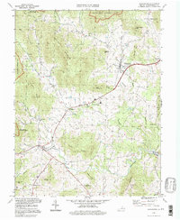 1994 Washington1997 Print · USGSRappahannock County remains a patchwork of historic Piedmont villages and mountain gaps in the 1990s. Genealogists and historians can trace the foundations of Washington, Sperryville, and Fletcher Mill alongside local landmarks like Old School Ch.
 - 1994 Map of Thornton Gap, 1997 Print
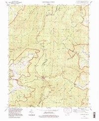 1994 Thornton Gap1997 Print · USGSThe high crest of the Blue Ridge is captured here in the 1990s as it divides Page and Rappahannock Counties. Hikers and historians can trace the Appalachian Trail past Pass Mountain Shelter or locate the park facilities at Panorama.
End of results
Showing maps 1-2 of 2
Top cities near Sperryville
- Culpeper historical maps
- Luray historical maps
- Brightwood historical maps
- Chester Gap historical maps
- Flint Hill historical maps
- Washington historical maps
Frequently asked questions
- What are the different types of historical maps available for Sperryville?
- What is the oldest map of Sperryville?
- Where can I purchase historical maps of Sperryville for my home or office?
- Where can I download high-res historical maps of Sperryville?
- Are there historical topographic maps available for Sperryville?
- Is there historical aerial imagery available for Sperryville?
- Where are historical maps of Sperryville sourced from?