Old Maps of Rockbridge County, Virginia for Academic Research
Study the evolution of Rockbridge County with 80 high-resolution historic maps. Whether you're teaching, researching, or modeling changes in land use, these maps provide essential visual documentation of urban, environmental, and geographic change.
- Analyze long-term change: Track patterns in development, transportation, and natural features.
- Ideal for environmental or urban studies: Support academic projects with primary historical map data.
- Use in the classroom or lab: Educators and researchers rely on these maps to bring historical context to life.
These maps are a powerful tool for teaching, research, and visualizing how Rockbridge County has changed over the decades.
Rockbridge County, VA maps
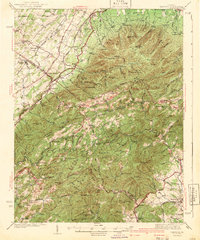
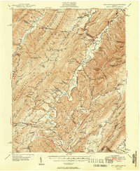
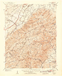
(80)- 1894 Map of Staunton, 1897 Print
 1894 Staunton1897 Print · USGSThe Shenandoah Valley was a hub of rail commerce and mountain industry in the 1890s, centered on the growing city of Staunton. Genealogists and historians can trace defunct rail stops and early industry at Giant Mills, Milnesville, and Stribling Spgs.8 unique versions available
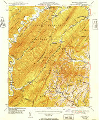
 - 1894 Map of Natural Bridge, 1898 Print
 1894 Natural Bridge1898 Print · USGSThe Virginia ridges thrived with iron furnaces and mineral springs during the 1890s. Genealogists and historians can trace the early industrial footprint of Long Dale Furnace and Victoria Mines, or locate local landmarks like Lick Run Ferry and Rapps Mill.7 unique versions available
 - 1894 Map of Lexington, 1900 Print
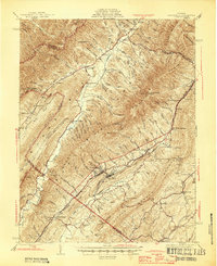
 1894 Lexington1900 Print · USGSAmherst and the surrounding Blue Ridge foothills are captured in the late nineteenth century during a period of rural expansion and early rail development. Genealogists can locate family homesteads near Clifford P.O. or trace landmarks like Cornerstone Ch. and Massies Mill.7 unique versions available
 - 1894 Map of Natural Bridge, 1926 Print
 1894 Natural Bridge1926 Print · USGSThe Virginia highlands during the 1890s were a powerhouse of iron production and river commerce. You can trace the rail-and-river economy through landmarks like the Lick Run Ferry, Victoria Mines, and the Long Dale Furnace.
 - 1901 Map of Monterey, 1905 Print
 1901 Monterey1905 Print · USGSThe high Allegheny ridges of Highland and Bath Counties are shown at the turn of the century when isolated valley settlements were linked by winding mountain gaps. Genealogists can trace early homesteads and commerce centers like Cleeks Mills, Mountaingrove, and New Hampden.8 unique versions available
 - 1907 Map of Natural Bridge Special
 1907 Natural Bridge Special1907 Print · USGSThe James River corridor in Botetourt and Rockbridge counties is captured here just after the turn of the century. Genealogists can locate family landmarks like Rapps Mill, Dunkard Church, and the riverfront settlement of Buchanan along the Chesapeake and Ohio RR.4 unique versions available
 - 1932 Map of Lexington
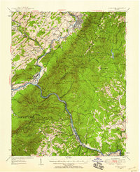
 1932 Lexington1932 Print · USGSRockbridge County in the early 1930s shows a landscape of academic centers and rural mill towns. Genealogists and historians can trace family locations near Rockbridge Alum Springs, Brownsburg Mill, or the segregated White Hall (Colored View) School.
 - 1935 Map of Buena Vista
 1935 Buena Vista1935 Print · USGSThe James River corridor in the mid-1930s reveals a landscape of hydroelectric power and deep-rooted mountain communities. Genealogists and historians can locate dozens of country schools and churches, from Ivory Hill Sch to Mt Zion Ch, alongside industrial sites like the LONE JACK QUARRY.
 - 1936 Map of Vesuvius
 1936 Vesuvius1936 Print · USGSThe Blue Ridge mountain front meets the Shenandoah Valley in the 1930s, showing a land of rail junctions and high-country mines. Researchers can trace the Appalachian Trail past peaks like The Priest and find local history at Steeles Tavern or Old Providence Cem.
 - 1937 Map of Lexington
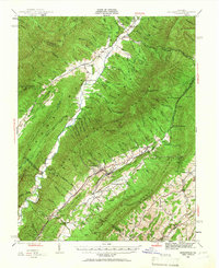
 1937 Lexington1937 Print · USGSRockbridge County during the mid-1930s shows a landscape defined by mountain gaps and the river-and-rail economy of the Shenandoah Valley. Researchers can trace old family names and rural infrastructure through Rockbridge Baths, McClung Mill, and New Monmouth Ch.3 unique versions available
 - 1939 Map of Buena Vista
 1939 Buena Vista1939 Print · USGSThe James River corridor near Buena Vista was a bustling intersection of rail and water transport in the years before World War II. Researchers can trace the early Appalachian Trail and find rural community hubs like Pedlar Mills, CCC Camp No 10, and Buffalo Forge.
 - 1940 Map of Buena Vista
 1940 Buena Vista1940 Print · USGSThe industrial and rail corridor of the James River is captured here as the region's mountain economy evolved in the 1930s. Researchers can trace the dual rail lines serving Glasgow, find CCC Camp No 10, and locate rural landmarks like Buffalo Forge and Ben Salam Sch.2 unique versions available
 - 1941 Map of Vesuvius
 1941 Vesuvius1941 Print · USGSThe Blue Ridge highlands at the start of the 1940s reveal a landscape of mountain mines and early parkway development. Genealogists and hikers can trace the Appalachian Trail past the Irish Creek Mission and forgotten sites like Mill Creek Sch.2 unique versions available
 - 1943 Map of Craigsville, 1961 Print
 1943 Craigsville1961 Print · USGSThe Virginia mountains in the early 1940s reveal a landscape of rail-dependent valley towns and isolated mountain gaps. You can trace family roots through rural landmarks like Griffin Ch, the Wilderness Sch, and the high peak at Elliott Knob.
 - 1945 Map of Craigsville
 1945 Craigsville1945 Print · USGSAugusta and Bath counties are shown here in the mid-1940s, when the rail lines still dictated the growth of mountain valley towns. Researchers can trace the Chesapeake and Ohio RR through Craigsville or locate rural sites like Rocky Spring Ch and Wilderness Sch.2 unique versions available
 - 1946 Map of Millboro, 1957 Print
 1946 Millboro1957 Print · USGSThe Alleghany and Rockbridge county lines are mapped here in the mid-1940s, highlighting a rugged corridor of industry and nature. Researchers can trace the Chesapeake and Ohio RR through the Lick Run Tunnel or locate Long Dale Furnace and Rockbridge Alum Springs.2 unique versions available
 - 1946 Map of Williamsville, 1964 Print
 1946 Williamsville1964 Print · USGSThe mountain valleys of Bath and Highland counties are captured here in the mid-1940s, showing a landscape of forest ridges and river settlements. Genealogists and hikers can locate old landmarks like Lockridge Memorial Ch, the Flood Sch, and the Duncan Knob Lookout Tower.
 - 1947 Map of Roanoke, 1948 Print
 1947 Roanoke1948 Print · USGSCentral Virginia in the late 1940s reveals a region defined by its great mountain ridges and the powerful river-and-rail economy connecting Roanoke to Lynchburg. Researchers can trace the path of the Virginian RR and locate historic county seats like Charlotte Court House.2 unique versions available
 - 1949 Map of Charlottesville
 1949 Charlottesville1949 Print · USGSThe Shenandoah Valley and Blue Ridge appear in the late 1940s as a thriving corridor of rail and river commerce. Researchers can trace the mid-century footprints of Harrisonburg, Staunton, and Culpeper alongside the historic routes of the Southern Railway.2 unique versions available
 - 1949 Map of Williamsville
 1949 Williamsville1949 Print · USGSThe ridges and valleys of Bath and Highland Counties come alive in this mid-century survey, documenting a time of remote mountain settlements and forest lookouts. Trace the locations of Starr Chapel, Flood Sch, and the high-elevation Duncan Knob Lookout Tower.2 unique versions available
 - 1949 Map of Millboro
 1949 Millboro1949 Print · USGSThe Virginia highlands between Bath and Rockbridge counties were still deeply defined by their iron-industry and railroad roots in the late 1940s. Genealogists and researchers can trace old family settlements at Nimrod Hall, visit historic sites like Long Dale Furnace, and locate rural landmarks such as Sharon Sch.2 unique versions available
 - 1950 Map of Lexington
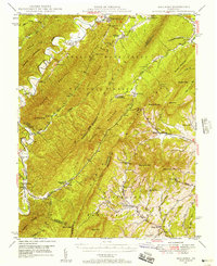
 1950 Lexington1950 Print · USGSRockbridge County and the Shenandoah Valley are shown in detail during the mid-twentieth century, centered on the bustling college town of Lexington. Researchers can trace the heritage of the Maury River valley through historic sites like Rockbridge Baths, Goshen Pass, and McClung Mill.2 unique versions available
 - 1950 Map of Buena Vista, 1958 Print
 1950 Buena Vista1958 Print · USGSThe Blue Ridge high country is captured here at mid-century as the Blue Ridge Parkway and Appalachian Trail were becoming established. Genealogists and historians can trace family locations near Pedlar Mills, Buffalo Forge, and the riverside rail junction at Glasgow.2 unique versions available
 - 1950 Map of Vesuvius, 1960 Print
 1950 Vesuvius1960 Print · USGSThe Blue Ridge high country of Augusta and Nelson counties comes alive in the mid-twentieth century, showing a landscape of remote mountain missions and state institutions. Genealogists and hikers can trace the Appalachian Trail past Irish Creek Mission, Montebello, and the State Prison Camp No 10.2 unique versions available
 - 1951 Map of Vesuvius
 1951 Vesuvius1951 Print · USGSThe Blue Ridge foothills of Augusta and Rockbridge Counties are shown here in the early fifties, capturing a landscape of mountain missions and remote mines. Trace family history through Old Providence Ch, the Irish Creek Mission, and Massies Mill.2 unique versions available
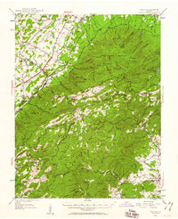
Showing maps 1-25 of 80
Top cities of Rockbridge County
Frequently asked questions
- What are the different types of historical maps available for Rockbridge County?
- What is the oldest map of Rockbridge County?
- Where can I purchase historical maps of Rockbridge County for my home or office?
- Where can I download high-res historical maps of Rockbridge County?
- Are there historical topographic maps available for Rockbridge County?
- Is there historical aerial imagery available for Rockbridge County?
- Where are historical maps of Rockbridge County sourced from?