1990s Maps of Rockbridge County, Virginia
Explore 7 historic maps of Rockbridge County from the 1990s. These maps offer a rare glimpse into what life looked like during the 1990s — showing old roads, neighborhoods, homes, and landmarks that have changed or disappeared over time.
Whether you're researching your family's past, planning a metal detecting trip, or studying how Rockbridge County's landscape evolved across the 1990s, these high-resolution maps are a powerful tool for exploring the history of this region.
- Focus on a specific era: All maps on this page are from the 1990s, giving you a focused view of this time period.
- See what’s changed: Compare century-old streets, trails, and buildings to today's modern landscape using overlays and satellite layers.
- Research with precision: Use these maps for genealogy, historical research, land use analysis, or educational projects.
- View, download, or print: Maps are fully viewable online in high resolution, and can be downloaded or printed for your own records.
Start exploring Rockbridge County's history through authentic maps from the 1990s. This is your window into the past.
Rockbridge County, VA maps
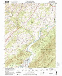
(7)- 1999 Map of Lexington, 2000 Print
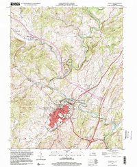 1999 Lexington2000 Print · USGSLexington and the Maury River valley are shown in the late 1990s as the region's historic academic and civic institutions reached their modern form. Researchers can trace the layout of the Virginia Military Institute and find local landmarks like Old Monmouth Cem and Newtown.
 - 1999 Map of Goshen, 2000 Print
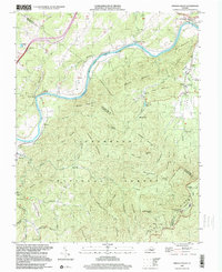
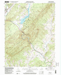 1999 Goshen2000 Print · USGSThe Maury River gorge and Lake Merriweather dominate this late-twentieth-century study of the Rockbridge County highlands. Researchers can locate remote mountain camps and old valley landmarks like Rockbridge Baths, Bethesda Ch, and Little River Cem.
 - 1999 Map of Buena Vista, 2000 Print
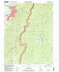 1999 Buena Vista2000 Print · USGSThe manufacturing center of Buena Vista and the surrounding Blue Ridge heights are captured here at the end of the twentieth century. Researchers can trace the path of the Appalachian Trail or locate the historic Southern Seminary Jr College campus and Oronoco Ch.
 - 1999 Map of Montebello, 2000 Print
 1999 Montebello2000 Print · USGSThe high ridges of the Blue Ridge define this portion of the George Washington National Forest at the turn of the millennium. Researchers can trace historic family burial sites at Grant Cem and Irish Creek Cem or locate the Montebello State Fish Hatchery.
 - 1999 Map of Glasgow, 2000 Print
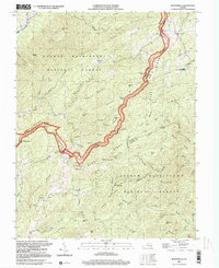
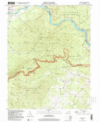
 1999 Glasgow2000 Print · USGSThe Maury and James rivers converge at Glasgow in the late twentieth century, where the valley floor meets the high ridges of the Blue Ridge. Trace the paths of early industrial sites like Buffalo Forge or locate rural landmarks such as Wesley Chapel and Mt Zion Ch.
 - 1999 Map of Arnold Valley, 2000 Print
 1999 Arnold Valley2000 Print · USGSThe James River and Blue Ridge heights meet in this mountain landscape at the end of the century. Genealogists and historians can trace the Chesapeake and Ohio rail line past Gilmore Mills or locate the Glenwood Furnace ruin and High Bridge Cem.
 - 1999 Map of Snowden, 2000 Print
 1999 Snowden2000 Print · USGSThe James River corridor at the end of the twentieth century shows a landscape where industrial infrastructure meets wilderness preservation. Researchers can trace the path of the Chesapeake and Ohio RR past Snowden or locate mountain landmarks like Sharon Ch and Highcock Knob.
End of results
Showing maps 1-7 of 7
Top cities of Rockbridge County
Frequently asked questions
- What are the different types of historical maps available for Rockbridge County?
- What is the oldest map of Rockbridge County?
- Where can I purchase historical maps of Rockbridge County for my home or office?
- Where can I download high-res historical maps of Rockbridge County?
- Are there historical topographic maps available for Rockbridge County?
- Is there historical aerial imagery available for Rockbridge County?
- Where are historical maps of Rockbridge County sourced from?