1930s Maps of Saltville, Virginia
Explore 6 historic maps of Saltville from the 1930s. These maps offer a rare glimpse into what life looked like during the 1930s — showing old roads, neighborhoods, homes, and landmarks that have changed or disappeared over time.
Whether you're researching your family's past, planning a metal detecting trip, or studying how Saltville's landscape evolved across the 1930s, these high-resolution maps are a powerful tool for exploring the history of this region.
- Focus on a specific era: All maps on this page are from the 1930s, giving you a focused view of this time period.
- See what’s changed: Compare century-old streets, trails, and buildings to today's modern landscape using overlays and satellite layers.
- Research with precision: Use these maps for genealogy, historical research, land use analysis, or educational projects.
- View, download, or print: Maps are fully viewable online in high resolution, and can be downloaded or printed for your own records.
Start exploring Saltville's history through authentic maps from the 1930s. This is your window into the past.
Saltville, VA maps
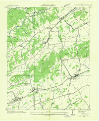
(6)- 1935 Map of Chilhowie
 1935 Chilhowie1935 Print · USGSSmyth County was a center of mountain industry and valley farming in the mid-1930s, defined by the Holston River forks. Researchers can trace historic family landmarks from Mathieson Alkali Works to rural centers like St Clair Bottom and Carlock Ch.
 - 1935 Map of Maccrady
 1935 Maccrady1935 Print · USGSSmyth and Tazewell Counties are shown here during the mid-1930s, as industrial activity along the river defined the local economy. Researchers can trace the path of the Mathieson Alkali Works R. R. and locate family landmarks like Carter Sch or Watsons Gap Sch.
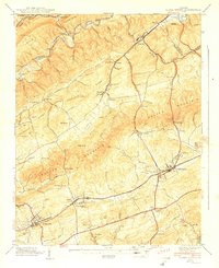
 - 1935 Map of Saltville
 1935 Saltville1935 Print · USGSSouthwest Virginia's industrial heart comes into focus during the mid-thirties as the salt-and-alkali economy thrives along the Holston River. Genealogists can trace the early footprint of Tumbling Creek College or locate long-standing landmarks like Belfast Mills and the Mathieson Alkali Works R R.
 - 1935 Map of Glade Spring
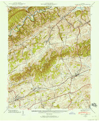
 1935 Glade Spring1935 Print · USGSSouthwest Virginia's ridge-and-valley landscape comes alive in the mid-1930s, showing the early path of the Appalachian Trail and the bustling campus of Emory and Henry College. Genealogists and historians can trace family-named sites like Blackwell, Moore, and Litz alongside the rail-driven economies of Saltville and Glade Spring.
 - 1938 Map of Glade Spring, 1958 Print
 1938 Glade Spring1958 Print · USGSWashington and Smyth counties in the late 1930s reveal a landscape shaped by the Norfolk and Western Railway and the valley's steep ridges. Genealogists can trace family footprints at Snodgrass Cem and the grounds of Emory and Henry College.5 unique versions available
 - 1939 Map of Glade Spring
 1939 Glade Spring1939 Print · USGSWashington and Smyth counties in the late 1930s reveal a landscape of coordinated valley settlements and mountain ridges. Researchers can trace historic family landmarks like Snoggrass Cem and Broady Cem or the campus layout of Emory and Henry College.2 unique versions available
End of results
Showing maps 1-6 of 6
Top cities near Saltville
- Abingdon historical maps
- Marion historical maps
- Richlands historical maps
- Raven historical maps
- Chilhowie historical maps
- Glade Spring historical maps
See more
Top neighborhoods of Saltville
Frequently asked questions
- What are the different types of historical maps available for Saltville?
- What is the oldest map of Saltville?
- Where can I purchase historical maps of Saltville for my home or office?
- Where can I download high-res historical maps of Saltville?
- Are there historical topographic maps available for Saltville?
- Is there historical aerial imagery available for Saltville?
- Where are historical maps of Saltville sourced from?