
1935 Map of Chilhowie
USGS Topo · Published 1935About this map
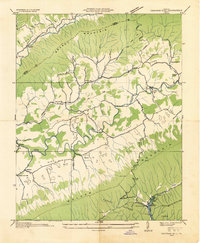
The town of Chilhowie sits at the heart of this Smyth County landscape, positioned where the Norfolk and Western railroad and the Middle Fork Holston River converge. This 1935 field examination reveals a highly developed corridor of early 20th-century industry and community life, anchored by the Mathieson Alkali Works near Saltville and the Aerial Tramway spanning Rich Valley. The map detail is particularly rich for local historians, recording numerous rural institutions including Campbells Chapel, St James Ch, and the Gallahorn Sch.
Find a feature on this map
47 named features on this map. Tap any name to fly to it.
Don’t see what you’re looking for? This feature index may not catch every label — zoom into the map to look around manually.
Map Details
Editions of this 1935 Chilhowie Map
This is the sole edition of this map. No revisions or reprints were ever made.
Other maps of this area

1891 · Abingdon
USGS Topo · 1:125,000

1894 · Abingdon
USGS Topo · 1:125,000

1909 · Abingdon
USGS Topo · 1:96,000

1911 · Abingdon
USGS Topo · 1:125,000
1934 · Chatham Hill
USGS Topo · 1:24,000

1935 · Konnarock
USGS Topo · 1:24,000

1935 · Maccrady
USGS Topo · 1:24,000

1935 · Mount Rogers
USGS Topo · 1:48,000

1935 · Saltville
USGS Topo · 1:24,000
1935 · Glade Spring
USGS Topo · 1:24,000