1935 Map of Glade Spring
USGS Topo · Published 1935About this map
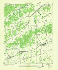
The campus of Emory and Henry College serves as a cultural and educational anchor in this mid-1930s landscape, situated along the Norfolk and Western Railway corridor. The geography is defined by parallel ridges and valleys, where industrial activity at Saltville and Plasterco contrasts with the rural reaches of Rich Valley and Poor Valley. An early route of the Appalachian Trail is traced across these heights, crossing Little Mountain near the North Fork Holston River.
Find a feature on this map
53 named features on this map. Tap any name to fly to it.
Don’t see what you’re looking for? This feature index may not catch every label — zoom into the map to look around manually.
Map Details
Editions of this 1935 Glade Spring Map
This is the sole edition of this map. No revisions or reprints were ever made.
Other maps of this area

1891 · Abingdon
USGS Topo · 1:125,000

1894 · Abingdon
USGS Topo · 1:125,000

1909 · Abingdon
USGS Topo · 1:96,000

1911 · Abingdon
USGS Topo · 1:125,000

1935 · Konnarock
USGS Topo · 1:24,000

1935 · Chilhowie
USGS Topo · 1:24,000

1935 · Maccrady
USGS Topo · 1:24,000

1935 · Abingdon
USGS Topo · 1:24,000

1935 · Mount Rogers
USGS Topo · 1:48,000

1935 · Saltville
USGS Topo · 1:24,000