1930s Maps of Shelleys, Virginia
Explore 4 historic maps of Shelleys from the 1930s. These maps offer a rare glimpse into what life looked like during the 1930s — showing old roads, neighborhoods, homes, and landmarks that have changed or disappeared over time.
Whether you're researching your family's past, planning a metal detecting trip, or studying how Shelleys's landscape evolved across the 1930s, these high-resolution maps are a powerful tool for exploring the history of this region.
- Focus on a specific era: All maps on this page are from the 1930s, giving you a focused view of this time period.
- See what’s changed: Compare century-old streets, trails, and buildings to today's modern landscape using overlays and satellite layers.
- Research with precision: Use these maps for genealogy, historical research, land use analysis, or educational projects.
- View, download, or print: Maps are fully viewable online in high resolution, and can be downloaded or printed for your own records.
Start exploring Shelleys's history through authentic maps from the 1930s. This is your window into the past.
Shelleys, VA maps
(4)- 1935 Map of Mendota
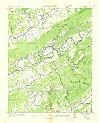 1935 Mendota1935 Print · USGSThe North Fork Holston River winds through Southwest Virginia in the mid-1930s, showing a landscape shaped by rail and river. Genealogists can locate family landmarks like Fleenors Mill Ford, Marys Chapel, and Taylor Sch.
 - 1935 Map of Mages
 1935 Mages1935 Print · USGSThe Tennessee-Virginia borderlands appear here in the mid-1930s, showing a landscape of ridge-and-valley settlements and rural crossroads. Researchers can locate numerous family-centered sites including Pyles Cem, St Joseph Ch, and Mill Point.
 - 1938 Map of Mendota, 1959 Print
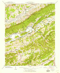 1938 Mendota1959 Print · USGSSouthwest Virginia's river valleys and mountain gaps are captured here just before the late thirties, showing a landscape shaped by the Southern Railway. Genealogists and local historians can locate Barker Mill, the Valley Institute, and several family cemeteries like Fleenor Cem.4 unique versions available
 - 1939 Map of Mendota
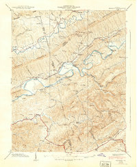 1939 Mendota1939 Print · USGSThe river valleys of Washington County were still dominated by the rail-and-water economy in the late 1930s. You can trace family landmarks and rural life through Mendota, the Barker Mill, and numerous river crossings like Stacher Ford.
End of results
Showing maps 1-4 of 4
Top cities near Shelleys
- Johnson City historical maps
- Kingsport historical maps
- Bristol historical maps
- Bristol historical maps
- Bloomingdale historical maps
- Oak Grove historical maps
See more
Frequently asked questions
- What are the different types of historical maps available for Shelleys?
- What is the oldest map of Shelleys?
- Where can I purchase historical maps of Shelleys for my home or office?
- Where can I download high-res historical maps of Shelleys?
- Are there historical topographic maps available for Shelleys?
- Is there historical aerial imagery available for Shelleys?
- Where are historical maps of Shelleys sourced from?