1900s (20th Century) Maps of Smyth County, Virginia
Explore 55 historic maps of Smyth County from the 1900s (20th Century). These maps offer a rare glimpse into what life looked like during the 1900s — showing old roads, neighborhoods, homes, and landmarks that have changed or disappeared over time.
Whether you're researching your family's past, planning a metal detecting trip, or studying how Smyth County's landscape evolved across the 1900s, these high-resolution maps are a powerful tool for exploring the history of this region.
- Focus on a specific era: All maps on this page are from the 1900s, giving you a focused view of this time period.
- See what’s changed: Compare century-old streets, trails, and buildings to today's modern landscape using overlays and satellite layers.
- Research with precision: Use these maps for genealogy, historical research, land use analysis, or educational projects.
- View, download, or print: Maps are fully viewable online in high resolution, and can be downloaded or printed for your own records.
Start exploring Smyth County's history through authentic maps from the 1900s. This is your window into the past.
Smyth County, VA maps
(55)- 1909 Map of Abingdon
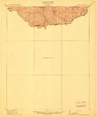
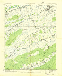
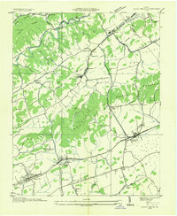
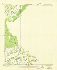
 1909 Abingdon1909 Print · USGSSouthwest Virginia at the first decade's end shows a valley landscape defined by the iron rail and steep ridges. Genealogists and historians can trace the early layouts of Abingdon and Glade Spring, or locate landmarks like Dove Mills and the County Farm.2 unique versions available
 - 1911 Map of Abingdon
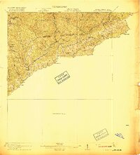
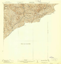
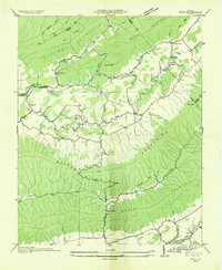
 1911 Abingdon1911 Print · USGSSouthwest Virginia's rugged corridors are captured here during the height of the mountain rail era. Genealogists and historians can trace old homesteads and local landmarks such as Whites Mill, Valley Church, and the County Farm near Abingdon.5 unique versions available
 - 1912 Map of Pounding Mill
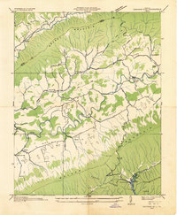
 1912 Pounding Mill1912 Print · USGSThe McDowell and Tazewell borderlands appear here in the decade before the First World War, showing the early infrastructure of this mountainous region. Researchers can trace the path of Squire Jim Road and locate the settlement of Horsepen among the headwaters of Big Creek.
 - 1916 Map of Pounding Mill
 1916 Pounding Mill1916 Print · USGSThe Virginia and West Virginia state line was a rugged landscape of isolated mountain hollows and ridge-top knobs during the early twentieth century. Genealogists can trace family footprints near Greasy Creek School, the NORFOLK AND WESTERN RR, and the settlement of Sayersville.
 - 1926 Map of Pounding Mill
 1926 Pounding Mill1926 Print · USGSAppalachian mountain life near the state line in the mid-twenties centers on remote hollows and high ridges. Researchers can trace the Norfolk and Western RR through Bandy or find family landmarks like the George Camp School and Sayersville.2 unique versions available
 - 1931 Map of Rural Retreat
 1931 Rural Retreat1931 Print · USGSSouthwestern Virginia in the early 1930s is defined by its ridge-and-valley terrain and the rail-and-road corridor of the Norfolk and Western. Genealogists can trace local landmarks like Wasson Cem, Roberts Mill, and the Old Iron Mine near Sugar Grove.
 - 1934 Map of Chatham Hill
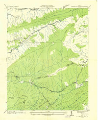
 1934 Chatham Hill1934 Print · USGSSmyth County's river valleys and ridgelines are captured here in the mid-1930s during the early development of the regional park system. Researchers can locate vanished landmarks like New Cove Sch, the site of the Proposed Hungry Mother Lake, and the crossing at Ellendale Ford.
 - 1934 Map of Tazewell
 1934 Tazewell1934 Print · USGSThe Clinch River headwaters and Appalachian ridges of Tazewell County are captured here in the mid-1930s. Researchers can trace the Norfolk and Western railroad through Maxwell or locate country landmarks like Creagers Mill and the Tazewell County Fair Grounds.
 - 1935 Map of Konnarock
 1935 Konnarock1935 Print · USGSThe mountains of Southwest Virginia come alive in the mid-1930s, showing the early reach of the Unaka National Forest. Local researchers can trace family roots through sites like Konnarock, Loves Mill, and several rural schoolhouses like Piedmont Sch.
 - 1935 Map of Chilhowie
 1935 Chilhowie1935 Print · USGSSmyth County was a center of mountain industry and valley farming in the mid-1930s, defined by the Holston River forks. Researchers can trace historic family landmarks from Mathieson Alkali Works to rural centers like St Clair Bottom and Carlock Ch.
 - 1935 Map of Nebo
 1935 Nebo1935 Print · USGSSmyth County mountain valleys and the Holston River are mapped here in the mid-1930s. Genealogists can locate family landmarks like Tilson Mill, Groseclose Store, and rural schoolhouses including Nebo Sch.
 - 1935 Map of Maccrady
 1935 Maccrady1935 Print · USGSSmyth and Tazewell Counties are shown here during the mid-1930s, as industrial activity along the river defined the local economy. Researchers can trace the path of the Mathieson Alkali Works R. R. and locate family landmarks like Carter Sch or Watsons Gap Sch.
 - 1935 Map of Mouth of Wilson
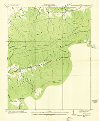
 1935 Mouth of Wilson1935 Print · USGSGrayson County was a landscape of high ridges and river crossings in the mid-1930s. Researchers can trace family sites at Youngs Chapel, find early crossings like Halsey Ferry, and locate old mountain schoolhouses like Oak Hill Sch and Fairwood Sch.
 - 1935 Map of Mount Rogers
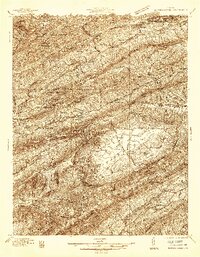
 1935 Mount Rogers1935 Print · USGSThe high peaks of Grayson and Smyth Counties are documented here in the mid-1930s as the Appalachian Trail was being established across Mount Rogers. Genealogists and historians can trace the foundations of mountain life at Konnarock, the Iron Mountain Boys Sch, and Taylors Valley.
 - 1935 Map of Cedar Springs
 1935 Cedar Springs1935 Print · USGSSouthwest Virginia's high ridges and hollows come into focus during the mid-1930s as the Smyth and Wythe county line is surveyed. Researchers can trace the exact locations of local landmarks like Lindamood Sch, Union Chapel, and the paths through Glade Hollow.
 - 1935 Map of Trout Dale
 1935 Trout Dale1935 Print · USGSGrayson and Smyth Counties are shown in the mid-1930s as a high-altitude landscape of national forest and developing highways. Researchers can trace the early route of the Appalachian Trail and find family-named landmarks like Houndshell Branch and Slabtown Br.
 - 1935 Map of Saltville
 1935 Saltville1935 Print · USGSSouthwest Virginia's industrial heart comes into focus during the mid-thirties as the salt-and-alkali economy thrives along the Holston River. Genealogists can trace the early footprint of Tumbling Creek College or locate long-standing landmarks like Belfast Mills and the Mathieson Alkali Works R R.
 - 1935 Map of Glade Spring
 1935 Glade Spring1935 Print · USGSSouthwest Virginia's ridge-and-valley landscape comes alive in the mid-1930s, showing the early path of the Appalachian Trail and the bustling campus of Emory and Henry College. Genealogists and historians can trace family-named sites like Blackwell, Moore, and Litz alongside the rail-driven economies of Saltville and Glade Spring.
 - 1935 Map of Hutchinson Rock
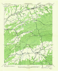
 1935 Hutchinson Rock1935 Print · USGSTazewell and Bland counties met along the high ridges of the Clinch Mountains during the mid-1930s. Researchers can trace early rural life through landmarks like Hutchinson Rock, the Thompson Sch, and several localized sites like Burkes Garden No 2.
 - 1935 Map of Whitetop Mountain
 1935 Whitetop Mountain1935 Print · USGSThe high peaks of Southwest Virginia appear here in the mid-1930s, featuring the summits and gaps of the Blue Ridge. Researchers can trace the early route of the Appalachian Trail and locate mountain landmarks like Konnarock Sch, Elk Garden, and Stony Creek Ch.
 - 1935 Map of Atkins
 1935 Atkins1935 Print · USGSSmyth County was a landscape of mountain ridges and river valleys in the mid-1930s, caught between rail-line growth and deep wilderness. Trace family history at Wassum Cem, locate the Camp Jaccard CCC No 3581, or find the old Roberts Mill.
 - 1935 Map of Groseclose
 1935 Groseclose1935 Print · USGSWythe County, Virginia, is captured in the mid-1930s along the vital Holston River transportation corridor. Genealogists and local historians can trace family land near Groseclose and Old Mt Airy, or locate community centers like Bethany Ch and Murpheyville Sch.
 - 1935 Map of Marion
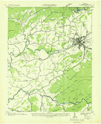 1935 Marion1935 Print · USGSMarion and its surrounding Smyth County valleys are captured during the mid-1930s, just as new conservation projects were shaping the landscape. Genealogists can trace family roots through numerous local landmarks like Holston Mill, the C C C Camp, and rural centers such as Adwolf and McMullin.
 - 1935 Map of Middle Fox Creek
 1935 Middle Fox Creek1935 Print · USGSThe Smyth and Grayson county line is captured during the mid-1930s as the regional landscape was being documented for the Tennessee Valley Authority. Researchers can trace early routes through Houndshell Gap and locate landmarks like Hemp Patch and the Appalachian Trail.
 - 1936 Map of Burkes Garden
 1936 Burkes Garden1936 Print · USGSTazewell and Bland Counties appear in the mid-1930s, defined by the extraordinary limestone bowl of Burkes Garden. Genealogists and historians can trace family locations near Maple Hill Cem, the Witten Mill settlement, and the industrial corridor at Bluefield.
Showing maps 1-25 of 55
Top cities of Smyth County
Frequently asked questions
- What are the different types of historical maps available for Smyth County?
- What is the oldest map of Smyth County?
- Where can I purchase historical maps of Smyth County for my home or office?
- Where can I download high-res historical maps of Smyth County?
- Are there historical topographic maps available for Smyth County?
- Is there historical aerial imagery available for Smyth County?
- Where are historical maps of Smyth County sourced from?