Old Maps of Spotsylvania County, Virginia for Genealogy
Trace your family roots with 90 historic maps of Spotsylvania County. These high-res maps reveal old neighborhoods, homesites, landmarks, and streets — helping you uncover where your ancestors lived and how the area evolved over time.
- Explore historic neighborhoods: Identify where your relatives may have lived in the 1800s or 1900s.
- Compare maps over time: Trace the changes in streets, buildings, and landmarks for multi-generational research.
- Perfect for genealogy & ancestry research: Used by family historians and researchers to map out lineage and migration.
These maps are an incredible resource for exploring your personal connection to Spotsylvania County's past.
Spotsylvania County, VA maps
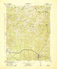
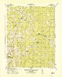
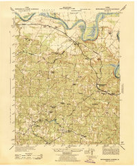
(90)- 1887 Map of Spottsylvania
 1887 Spottsylvania1887 Print · USGSCentral Virginia in the late 1880s remains a landscape of river fords and crossroads shops before modern development. Genealogists and historians can trace the locations of the Vaucluse Gold Mine, Wilderness Tavern, and the path of the Narrow Gauge Railroad.
 - 1889 Map of Fredericksburg
 1889 Fredericksburg1889 Print · USGSThe Tidewater region of Virginia and Maryland comes into focus in the late 1880s, centered on the river-and-rail hub of Fredericksburg. Genealogists can trace early landmarks like Rappahannock Academy, Bull Church, and Saunders Wharf.
 - 1890 Map of Goochland
 1890 Goochland1890 Print · USGSGoochland and the surrounding Virginia Piedmont are captured here in the late nineteenth century as the river-and-rail economy thrived. Researchers can trace the paths of the Chesapeake and Ohio Railroad and find landmarks like Hopeful Church or the Coal Pits.
 - 1892 Map of Fredericksburg
 1892 Fredericksburg1892 Print · USGSCoastal Virginia and Maryland are captured here in the late nineteenth century, showing a landscape of river-port towns and historic crossroads. Researchers can locate vanished landmarks and family sites like Rappahannock Academy, Whites Mill, and the riverside Port Royal.
 - 1892 Map of Spottsylvania
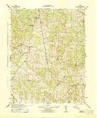
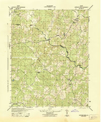
 1892 Spottsylvania1892 Print · USGSCentral Virginia’s post-war landscape is captured here in the late nineteenth century, showing a rural economy defined by gold mining and river crossings. Genealogists can trace family footprints at Todds Tavern, the Vaucluse Gold Mine, and along the Narrow Gauge Railroad.6 unique versions available
 - 1892 Map of Goochland
 1892 Goochland1892 Print · USGSThe rural heart of central Virginia is captured here in the decade before the turn of the century, showing a landscape shaped by major rivers and early rail lines. Genealogists can trace family names and early settlements like Negro Foot, Mabelton, and the historic Hanover Academy.8 unique versions available
 - 1894 Map of Fredericksburg
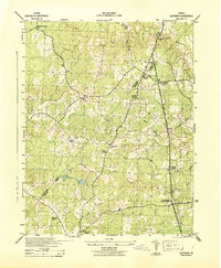
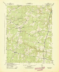
 1894 Fredericksburg1894 Print · USGSThe Tidewater and Piedmont regions of Virginia meet in the late nineteenth century at the head of the Rappahannock River. Local historians can trace early inland commerce through rural centers like Nindes Store, the Rappahannock Academy, and Stafford.10 unique versions available
 - 1926 Map of Stafford, 1956 Print
 1926 Stafford1956 Print · USGSStafford County and the Rappahannock River valley appear here in the mid-twenties, balancing colonial-era heritage with early twentieth-century growth. Genealogists can locate family landmarks like Bridges Store, Passapatanzy, and the historic Aquia Ch along the rail lines.
 - 1931 Map of Stafford
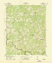
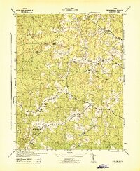
 1931 Stafford1931 Print · USGSStafford County and the city of Fredericksburg are shown here in the early 1930s, documenting a landscape still deeply shaped by nineteenth-century transit and conflict. Genealogists and historians can locate family landmarks like Mountain View PO, Enon Sch, and the grounds of the Battle of Fredericksburg 1862.
 - 1942 Map of Woodford
 1942 Woodford1942 Print · USGSCaroline County's rural crossroads and river systems are meticulously detailed in this early wartime survey. Genealogists and historians can trace family locations near Woodford, Burkes Shop, and Bethel Church, or follow the Mattaponi River valley.3 unique versions available
 - 1942 Map of Mineral
 1942 Mineral1942 Print · USGSLouisa County during the early years of the war shows a landscape of rural crossroads and established rail hubs. Trace local history through family landmarks like Bibbs Store, Holladay Mill, and the many churches like Miners Chapel along the Chesapeake and Ohio line.2 unique versions available
 - 1942 Map of Guinea
 1942 Guinea1942 Print · USGSSpotsylvania and Caroline counties are seen here in the early 1940s as the rail-driven economy of the Rappahannock valley meets the expansion of federal military lands. Genealogists can locate family-named hubs like Flippos Corner, rural schools such as New Hope School, and the crossroads at Guinea.
 - 1942 Map of Ladysmith
 1942 Ladysmith1942 Print · USGSCaroline County and its borders during the early war years reveal a rural landscape of crossroads hamlets and family-run mills. Researchers can trace historic family landmarks and community centers like Colemans Mill, Ann Wrights Corner, and Beulah Church.2 unique versions available
 - 1942 Map of Lahore
 1942 Lahore1942 Print · USGSOrange County and the surrounding borderlands were a network of rural hamlets and airway navigation markers during the early 1940s. Genealogists can locate family landmarks like Terrells Store, North Pamunkey Church, and the Isabella Lightfoot Training School.2 unique versions available
 - 1942 Map of Partlow
 1942 Partlow1942 Print · USGSSpotsylvania County during the early years of the war remained a landscape of rural general stores and winding river crossings. Genealogists and local historians can trace family locations near Duerson Store, Wallers Church, and Partlow.2 unique versions available
 - 1942 Map of Belmont
 1942 Belmont1942 Print · USGSSpotsylvania and Orange Counties are captured here during the early years of the war, revealing a landscape of rural crossroads and mining operations. Researchers can trace family roots through landmarks like Richards Shop, Bells Cross Road, and the Valzinco Mine.2 unique versions available
 - 1942 Map of Contrary Creek
 1942 Contrary Creek1942 Print · USGSSpotsylvania and Louisa counties appear here in the early 1940s as a landscape of rural crossroads and river bottomlands. Researchers can trace historic family locations near Poindexters Store, Good Hope Church, and the winding North Anna River.2 unique versions available
 - 1942 Map of Spotsylania
 1942 Spotsylania1942 Print · USGSSpotsylvania County is shown here in the early years of the second World War, a landscape where the legacies of the Civil War meet a rural river-basin economy. Genealogists and historians can trace local landmarks like Zion Church, Lonewall School, and the crossroads at Fraziers Gate.2 unique versions available
 - 1942 Map of Brokenburg
 1942 Brokenburg1942 Print · USGSSpotsylvania County was largely rural and agrarian during the early war years, characterized by crossroads settlements and mill sites. Researchers can find old community hubs like Brokenburg, Todds Tavern, and the historic Spotsylvania Camp Meeting grounds.2 unique versions available
 - 1942 Map of Rappahannock Academy, 1944 Print
 1942 Rappahannock Academy1944 Print · USGSThe Rappahannock River valley in the early 1940s reveals a rural landscape undergoing a massive military transformation. You can trace the early layout of the A P Hill Military Reservation and locate historic community centers like Rappahannock Academy and Travis Mill.
 - 1942 Map of Beaverdam, 1961 Print
 1942 Beaverdam1961 Print · USGSHanover and Louisa counties were largely defined by the rail and river network of the early 1940s. Researchers can trace the layout of small crossroads communities and family-named landmarks such as Greenes Corner, Lazarus Chapel, and the Beaverdam Sch.
 - 1943 Map of Beaverdam
 1943 Beaverdam1943 Print · USGSMid-century Hanover and Louisa counties revolve around the railroad and timber trades during the early years of the war. Genealogists and historians can trace the local hubs of Beaverdam and Bumpass, alongside rural anchors like Lazarus Chapel and Harris Store.
 - 1943 Map of Chancellorsville, 1957 Print
 1943 Chancellorsville1957 Print · USGSSpotsylvania and Orange counties are captured during the early 1940s, highlighting the preserved grounds of the Wilderness National Military Park. Genealogists can trace family footprints at Paynes Store, Zion Hill Church, and the Parker School located near the Ni River.
 - 1943 Map of Salem Church, 1961 Print
 1943 Salem Church1961 Print · USGSCentral Virginia during the mid-forties reveals a rural landscape of family-named runs and hilltop parishes. Genealogists and historians can trace local life through markers like Chancellor Sch, Zoan Ch, and the crossroads at Holly Corner.
 - 1943 Map of Fredericksburg, 1961 Print
 1943 Fredericksburg1961 Print · USGSVirginia's Rappahannock valley is captured here during the war years, balancing its deep Civil War history with mid-century development. Genealogists and historians can trace family-named sites and landmarks like Oak Hill Cem, Dunker Ch, and the Meade Pyramid.
Showing maps 1-25 of 90
Top cities of Spotsylvania County
Frequently asked questions
- What are the different types of historical maps available for Spotsylvania County?
- What is the oldest map of Spotsylvania County?
- Where can I purchase historical maps of Spotsylvania County for my home or office?
- Where can I download high-res historical maps of Spotsylvania County?
- Are there historical topographic maps available for Spotsylvania County?
- Is there historical aerial imagery available for Spotsylvania County?
- Where are historical maps of Spotsylvania County sourced from?