1940s Maps of Suffolk, Virginia
Explore 7 historic maps of Suffolk from the 1940s. These maps offer a rare glimpse into what life looked like during the 1940s — showing old roads, neighborhoods, homes, and landmarks that have changed or disappeared over time.
Whether you're researching your family's past, planning a metal detecting trip, or studying how Suffolk's landscape evolved across the 1940s, these high-resolution maps are a powerful tool for exploring the history of this region.
- Focus on a specific era: All maps on this page are from the 1940s, giving you a focused view of this time period.
- See what’s changed: Compare century-old streets, trails, and buildings to today's modern landscape using overlays and satellite layers.
- Research with precision: Use these maps for genealogy, historical research, land use analysis, or educational projects.
- View, download, or print: Maps are fully viewable online in high resolution, and can be downloaded or printed for your own records.
Start exploring Suffolk's history through authentic maps from the 1940s. This is your window into the past.
Suffolk, VA maps
(7)- 1940 Map of Lake Drummond, 1964 Print
 1940 Lake Drummond1964 Print · USGSThe Great Dismal Swamp and its drainage canals are captured here in the 1940s, showing a landscape defined by timber extraction and transit. Genealogists and historians can trace old schools and landings from Jacks Camp to Wallaceton Sch and the Lumber RR.
 - 1943 Map of Holland
 1943 Holland1943 Print · USGSThe Virginia and North Carolina borderlands come alive in this mid-century survey of the Chowan River basin. Local historians can trace a network of river landings and rural schools, from Manning Ferry to the community around Stony Branch Church.
 - 1944 Map of Windsor
 1944 Windsor1944 Print · USGSCoastal Virginia during the mid-forties reveals a rural landscape of timber, mills, and rail-dependent towns. Genealogists and historians can trace family locations near landmarks like the Shiloh Cem, Greshem School, and the junction at Five Forks.2 unique versions available
 - 1944 Map of Zuni, 1961 Print
 1944 Zuni1961 Print · USGSThe Virginia Coastal Plain along the Isle of Wight and Southampton border comes alive in this mid-1940s survey. Researchers can trace rural community life through numerous local landmarks, from Tucker Swamp Ch and Gay Sch to the wetlands of Burnt Mills Swamp.
 - 1945 Map of Zuni
 1945 Zuni1945 Print · USGSCoastal Virginia during the mid-1940s reveals a rural landscape defined by the Blackwater River and the competing Norfolk and Western and Virginian rail lines. Researchers can trace local heritage through landmarks like Antioch Ch and Cem and the crossroads at Zuni and Walters.
 - 1945 Map of Lake Drummond
 1945 Lake Drummond1945 Print · USGSThe Dismal Swamp straddles the Virginia-North Carolina line in the 1940s, revealing a landscape defined by timber extraction and historic waterways. Researchers can trace the Intracoastal Waterway, the Lumber RR, and local centers like Wallaceton and Deep Creek.
 - 1949 Map of Chuckatuck
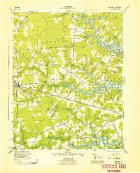
 1949 Chuckatuck1949 Print · USGSCoastal Virginia in the late 1940s is shown here as a landscape of tidewater inlets and busy railroad corridors. Genealogists and local historians can trace family locations near the Rosenwald School, Canaan Cem, and rural churches like St Johns Ch or Little Bethel Ch.
End of results
Showing maps 1-7 of 7
Top cities of Suffolk
Frequently asked questions
- What are the different types of historical maps available for Suffolk?
- What is the oldest map of Suffolk?
- Where can I purchase historical maps of Suffolk for my home or office?
- Where can I download high-res historical maps of Suffolk?
- Are there historical topographic maps available for Suffolk?
- Is there historical aerial imagery available for Suffolk?
- Where are historical maps of Suffolk sourced from?