1960s Maps of Surry County, Virginia
Explore 13 historic maps of Surry County from the 1960s. These maps offer a rare glimpse into what life looked like during the 1960s — showing old roads, neighborhoods, homes, and landmarks that have changed or disappeared over time.
Whether you're researching your family's past, planning a metal detecting trip, or studying how Surry County's landscape evolved across the 1960s, these high-resolution maps are a powerful tool for exploring the history of this region.
- Focus on a specific era: All maps on this page are from the 1960s, giving you a focused view of this time period.
- See what’s changed: Compare century-old streets, trails, and buildings to today's modern landscape using overlays and satellite layers.
- Research with precision: Use these maps for genealogy, historical research, land use analysis, or educational projects.
- View, download, or print: Maps are fully viewable online in high resolution, and can be downloaded or printed for your own records.
Start exploring Surry County's history through authentic maps from the 1960s. This is your window into the past.
Surry County, VA maps
(13)- 1964 Map of Richmond
 1964 Richmond1964 Print · USGSCoastal and central Virginia are mapped during the mid-twentieth century, showing the critical intersection of rail, river, and military life. Genealogists can trace family roots through rural county seats like Amelia or find vanished coastal neighborhoods near Phoebus and Hilton Village.
 - 1965 Map of Hog Island, 1966 Print
 1965 Hog Island1966 Print · USGSThe James River waterfront in the mid-1960s serves as a crossroads of military installations and colonial landmarks. Researchers can trace the grounds of the Carters Grove Historical Home, the early church at Zion Ch, and the coastal defenses of Camp Wallace Military Reservation.4 unique versions available
 - 1965 Map of Disputanta North, 1967 Print
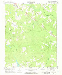
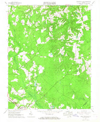 1965 Disputanta North1967 Print · USGSPrince George and Surry Counties during the mid-1960s show a landscape of timbered wetlands and quiet crossroads. Genealogists can trace family roots through Bethlehem Ch, Lebanon Ch, and sites like Binford Store or Garysville.2 unique versions available
 - 1965 Map of Surry, 1967 Print
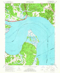
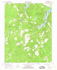
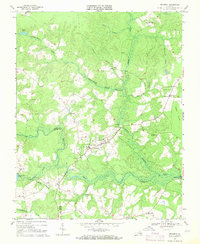
 1965 Surry1967 Print · USGSThe historic James River corridor comes to life in the 1960s, showing the vital ferry link between colonial Jamestown and the rural community of Surry. Researchers can trace old property lines and landmarks such as Smith Fort, Cobham Wharf, and the Lebanon Ch.3 unique versions available
 - 1966 Map of Claremont
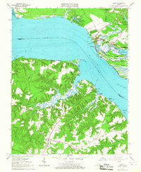
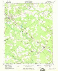
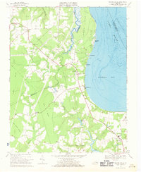
 1966 Claremont1966 Print · USGSThe James River shoreline and Surry County interior are captured here during the mid-sixties as the region maintained its rural character. Genealogists and historians can locate family landmarks such as Claremont Manor, the Mercy Seat Ch, and remnants of an Old Railroad Grade.4 unique versions available
 - 1966 Map of Savedge, 1967 Print
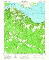
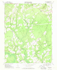
 1966 Savedge1967 Print · USGSThe rural Virginia Tidewater comes into focus during the mid-sixties, showing the marshy borderlands of Surry and Prince George counties. Researchers can trace historic family locations near Johnsons Landing or locate old community centers like Brandon Ch and Lone Oak Mill.2 unique versions available
 - 1968 Map of Runnymede, 1970 Print
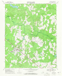
 1968 Runnymede1970 Print · USGSSurry County remains a land of deep swamps and rural crossroads in the late sixties, where the Blackwater River winds through the Tidewater. Genealogists and historians can trace family locations near Moores Swamp Ch, Derrings Mill, and the Old Railroad Grade.4 unique versions available
 - 1968 Map of Disputanta South, 1970 Print
 1968 Disputanta South1970 Print · USGSSussex and Prince George counties were characterized by vast wetlands and rail-side villages in the late sixties. Researchers can trace rural church locations like Wilburn Church and follow the Norfolk and Western line through Disputanta.3 unique versions available
 - 1968 Map of Raynor, 1970 Print
 1968 Raynor1970 Print · USGSIsle of Wight and Southampton counties are depicted in the late sixties as a landscape of interconnected wetlands and rural crossroads. Local historians can trace family locations near Raynor and Stotts Crossroads or find old community centers like Mill Swamp Ch.2 unique versions available
 - 1968 Map of Ivor, 1970 Print
 1968 Ivor1970 Print · USGSCoastal Virginia's timber and rail country comes into focus in the late sixties as the Norfolk and Western line links rural crossroads. Genealogists and historians can trace family locations from Wakefield to Ivor, finding landmarks like Berlin-Ivor Sch and Spratley Cem.4 unique versions available
 - 1969 Map of Waverly, 1971 Print
 1969 Waverly1971 Print · USGSWaverly and the Surry and Sussex county line are captured here in the late sixties as the Norfolk and Western railroad powered the local economy. Researchers can trace rural church locations like Jerusalem Ch and Zion Hill Ch or explore old transit lines like the Old Railroad Grade.3 unique versions available
 - 1969 Map of Dendron, 1971 Print
 1969 Dendron1971 Print · USGSSurry and Sussex counties are shown in the late sixties as a patchwork of timbered swamps and small farming communities. You can locate vanished local landmarks like Spratleys Mill, the County Academy, and rural congregations including St Marys Church.2 unique versions available
 - 1969 Map of Bacons Castle, 1971 Print
 1969 Bacons Castle1971 Print · USGSThe Virginia Tidewater near the Surry and Isle of Wight border remains a landscape of coastal creeks and rural hamlets in the late sixties. Genealogists can locate family landmarks like Bacons Castle, Wrenns Millpond, and several historic congregations such as Little Zion Ch.3 unique versions available
End of results
Showing maps 1-13 of 13
Top cities of Surry County
Frequently asked questions
- What are the different types of historical maps available for Surry County?
- What is the oldest map of Surry County?
- Where can I purchase historical maps of Surry County for my home or office?
- Where can I download high-res historical maps of Surry County?
- Are there historical topographic maps available for Surry County?
- Is there historical aerial imagery available for Surry County?
- Where are historical maps of Surry County sourced from?