1960s Maps of Sussex County, Virginia
Explore 19 historic maps of Sussex County from the 1960s. These maps offer a rare glimpse into what life looked like during the 1960s — showing old roads, neighborhoods, homes, and landmarks that have changed or disappeared over time.
Whether you're researching your family's past, planning a metal detecting trip, or studying how Sussex County's landscape evolved across the 1960s, these high-resolution maps are a powerful tool for exploring the history of this region.
- Focus on a specific era: All maps on this page are from the 1960s, giving you a focused view of this time period.
- See what’s changed: Compare century-old streets, trails, and buildings to today's modern landscape using overlays and satellite layers.
- Research with precision: Use these maps for genealogy, historical research, land use analysis, or educational projects.
- View, download, or print: Maps are fully viewable online in high resolution, and can be downloaded or printed for your own records.
Start exploring Sussex County's history through authentic maps from the 1960s. This is your window into the past.
Sussex County, VA maps
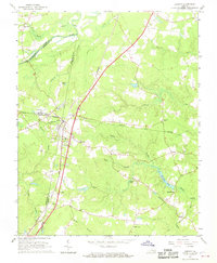
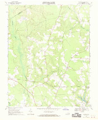
(19)- 1963 Map of Cherry Hill, 1964 Print
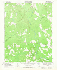
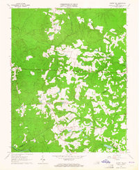 1963 Cherry Hill1964 Print · USGSDinwiddie and Sussex counties come alive in the early 1960s, showing a traditional landscape of crossroads stores and family holdings. Genealogists can locate numerous family burial sites like Boisseau Cem and Bain Cem or centers of community life at Wharf's Store and Masontown Sch.3 unique versions available
 - 1963 Map of Purdy, 1964 Print
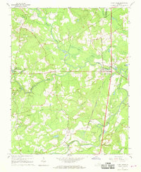
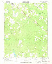
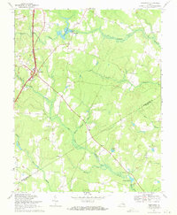
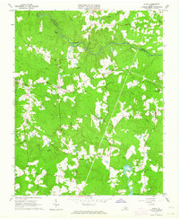 1963 Purdy1964 Print · USGSGreensville and Sussex counties are captured here in the early sixties, showing a landscape of river-bottom swamps and rural railroad hamlets. Genealogists can trace family landmarks like Cowie Cem, Coyie Corner, and several country churches including St Johns Ch.3 unique versions available
 - 1964 Map of Richmond
 1964 Richmond1964 Print · USGSCoastal and central Virginia are mapped during the mid-twentieth century, showing the critical intersection of rail, river, and military life. Genealogists can trace family roots through rural county seats like Amelia or find vanished coastal neighborhoods near Phoebus and Hilton Village.
 - 1966 Map of Drewryville, 1968 Print
 1966 Drewryville1968 Print · USGSSouthampton County during the mid-sixties reveals a landscape of rural crossroads and timbered wetlands tied together by the Norfolk and Western railway. Researchers can trace local heritage through landmarks like Persons Ch, Hebron Ch, and the brick Kilns near the eastern border.2 unique versions available
 - 1966 Map of Adams Grove, 1968 Print
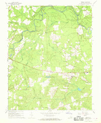
 1966 Adams Grove1968 Print · USGSSouthampton and Greensville Counties are captured here in the mid-sixties, showing a landscape defined by meandering river bends and timber-linked rail lines. Genealogists and historians can trace rural landmarks from Grizzard to Adams Grove, including Pleasant Grove Cem and the Meherrin River.3 unique versions available
 - 1966 Map of Jarratt, 1968 Print
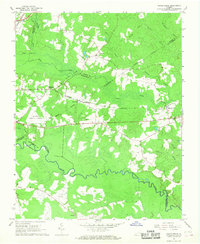
 1966 Jarratt1968 Print · USGSThe rail junction at Jarratt and the surrounding swamps of Southside Virginia are captured here in the mid-sixties. Genealogists and local historians can trace family locations near Jefferson Sch or rural landmarks like Harrells Mill and Bethlehem Ch.4 unique versions available
 - 1966 Map of Yale, 1968 Print
 1966 Yale1968 Print · USGSCoastal plain Virginia in the mid-1960s reveals a landscape of isolated hamlets and active rail corridors. Researchers can trace the legacy of small communities like Hilda and Joyner, while locating landmarks such as Russian Ch and Rivers Mill.3 unique versions available
 - 1967 Map of Sussex, 1968 Print
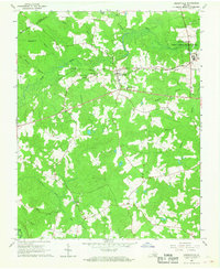
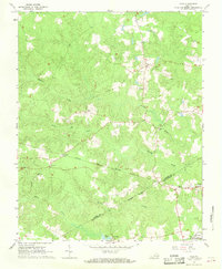
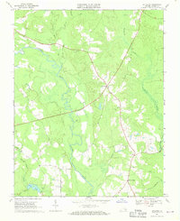
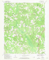
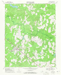
 1967 Sussex1968 Print · USGSSussex County in the late sixties remains a landscape of deep river swamps and quiet crossroads. Genealogists and local historians can locate Howells Mill, trace family roots at Bethel Cem, and find old gathering places like Comans Well and Red Oak Ch.3 unique versions available
 - 1967 Map of Stony Creek, 1968 Print
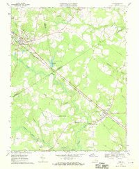
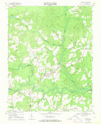
 1967 Stony Creek1968 Print · USGSCoastal Plain wetlands and river crossings define the landscape of central Sussex County in the late sixties. Researchers can trace the Seaboard Coast Line corridor through Stony Creek and locate landmarks like Winfields Mill and Sappony Ch.3 unique versions available
 - 1968 Map of Sebrell, 1970 Print
 1968 Sebrell1970 Print · USGSSouthampton County was still a quiet landscape of river crossings and small churches in the late sixties. Genealogists can locate family landmarks like Butts Cem or trace the routes of the Norfolk and Western and the Old Railroad Grade.2 unique versions available
 - 1968 Map of Disputanta South, 1970 Print
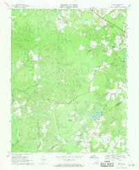
 1968 Disputanta South1970 Print · USGSSussex and Prince George counties were characterized by vast wetlands and rail-side villages in the late sixties. Researchers can trace rural church locations like Wilburn Church and follow the Norfolk and Western line through Disputanta.3 unique versions available
 - 1968 Map of Littleton, 1970 Print
 1968 Littleton1970 Print · USGSSussex County during the late 1960s was a landscape of intricate river bends and quiet crossroads. Researchers can trace the layout of small communities like Homeville and Littleton, or locate rural landmarks such as Plank Road Ch and Barretts Store.2 unique versions available
 - 1968 Map of Ivor, 1970 Print
 1968 Ivor1970 Print · USGSCoastal Virginia's timber and rail country comes into focus in the late sixties as the Norfolk and Western line links rural crossroads. Genealogists and historians can trace family locations from Wakefield to Ivor, finding landmarks like Berlin-Ivor Sch and Spratley Cem.4 unique versions available
 - 1969 Map of Vicksville, 1970 Print
 1969 Vicksville1970 Print · USGSSouthampton County during the late 1960s was a landscape of rail-linked hamlets and expansive wetlands. Genealogists and researchers can locate family sites near Vicksville, St Lukes Ch, and the crossings of the NORFOLK AND WESTERN railroad.3 unique versions available
 - 1969 Map of Templeton, 1971 Print
 1969 Templeton1971 Print · USGSPrince George and Sussex counties during the late 1960s reveal a landscape of rural junctions and swamp-side communities. You can trace old mill sites at Lees Millpond and locate local landmarks like Tar Road Ch and Templeton.2 unique versions available
 - 1969 Map of Carson, 1971 Print
 1969 Carson1971 Print · USGSThe rural landscape near the Dinwiddie and Prince George county line comes to life in this late-sixties study. Genealogists can trace family roots through several landmarks, including the Confederate Cem, Rowanty Ch, and the village of Carson.5 unique versions available
 - 1969 Map of Manry, 1971 Print
 1969 Manry1971 Print · USGSThe Sussex and Southampton county borderlands come into focus in the late sixties, showcasing a landscape of lowland swamps and rural crossroads. Genealogists and local historians can trace family-named landmarks like Barrett Corner, Laniers Millpond, and Hebron Ch.
 - 1969 Map of Waverly, 1971 Print
 1969 Waverly1971 Print · USGSWaverly and the Surry and Sussex county line are captured here in the late sixties as the Norfolk and Western railroad powered the local economy. Researchers can trace rural church locations like Jerusalem Ch and Zion Hill Ch or explore old transit lines like the Old Railroad Grade.3 unique versions available
 - 1969 Map of Dendron, 1971 Print
 1969 Dendron1971 Print · USGSSurry and Sussex counties are shown in the late sixties as a patchwork of timbered swamps and small farming communities. You can locate vanished local landmarks like Spratleys Mill, the County Academy, and rural congregations including St Marys Church.2 unique versions available
End of results
Showing maps 1-19 of 19
Top cities of Sussex County
Frequently asked questions
- What are the different types of historical maps available for Sussex County?
- What is the oldest map of Sussex County?
- Where can I purchase historical maps of Sussex County for my home or office?
- Where can I download high-res historical maps of Sussex County?
- Are there historical topographic maps available for Sussex County?
- Is there historical aerial imagery available for Sussex County?
- Where are historical maps of Sussex County sourced from?