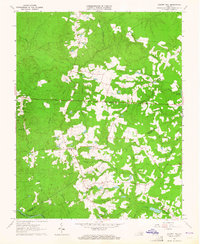
1963 Map of Cherry Hill
USGS Topo · Published 1964About this map
Wharf's Store and Bolsters Store anchor the rural crossroads of south-central Virginia in the early 1960s, a landscape defined by small family farmsteads and a dense network of private burial grounds. The map detail is particularly useful for genealogists, documenting over a dozen named family cemeteries such as Boisseau Cem, Bain Cem, and Carraway Cem scattered across the wooded divides. This 1963 field-checked survey also captures local educational and spiritual life at the Masontown Sch and Lloyds Ch. The terrain transitions from the headwaters of Sappony Creek in the north toward the Nottoway River along the southern boundary, where the Winfields Millpond suggests the remnants of water-powered industry at the edge of Dinwiddie County.
Find a feature on this map
38 named features on this map. Tap any name to fly to it.
Don’t see what you’re looking for? This feature index may not catch every label — zoom into the map to look around manually.
Map Details
Editions of this 1963 Cherry Hill Map
3 editions found
Other maps of this area

1894 · Petersburg
USGS Topo · 1:62,500

1897 · Amelia
USGS Topo · 1:125,000

1919 · Jarratt
USGS Topo · 1:62,500

1919 · Mc Kenney
USGS Topo · 1:48,000

1921 · Mc Kenney
USGS Topo · 1:62,500

1943 · Mc Kenney
USGS Topo · 1:62,500

1943 · De Witt
USGS Topo · 1:24,000

1943 · Dinwiddie
USGS Topo · 1:24,000

1943 · Richmond
USGS Topo · 1:250,000

1944 · Reams
USGS Topo · 1:31,680