
1943 Map of De Witt
USGS Topo · Published 1961About this map
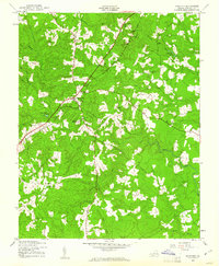
The Seaboard Air Line railroad cuts a sharp diagonal path through the Dinwiddie County countryside, anchoring the small settlement of DeWitt during the early 1940s. This rural landscape is defined by its drainage systems, where White Oak Creek and Butterwood Creek wind through dense woods toward Stony Creek. The map reveals a community structured around its spiritual and social centers, featuring numerous rural houses of worship including Mt Calvary Ch, Bott Memorial Ch, and Eleven Oak Ch.
Find a feature on this map
24 named features on this map. Tap any name to fly to it.
Don’t see what you’re looking for? This feature index may not catch every label — zoom into the map to look around manually.
Map Details
Editions of this 1943 De Witt Map
This is the sole edition of this map. No revisions or reprints were ever made.
Other maps of this area

1897 · Amelia
USGS Topo · 1:125,000

1918 · Lawrenceville
USGS Topo · 1:62,500

1919 · Mc Kenney
USGS Topo · 1:48,000

1920 · Lawrenceville
USGS Topo · 1:48,000

1921 · Mc Kenney
USGS Topo · 1:62,500

1921 · Lawrenceville
USGS Topo · 1:62,500

1942 · Lawrenceville
USGS Topo · 1:62,500

1943 · Mc Kenney
USGS Topo · 1:62,500
1943 · Dinwiddie
USGS Topo · 1:24,000

1943 · Church Road
USGS Topo · 1:24,000