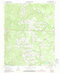
1963 Map of Cherry Hill
USGS Topo · Published 1985About this map
Wharfs Store and Bolsters Store anchor the rural crossroads of this Southside Virginia landscape, which straddles the borders of Dinwiddie and Sussex counties. Surveyed in the early 1960s, the terrain is defined by a dense network of family-named cemeteries and landmarks that speak to generations of local settlement. The drainage patterns of Sappony Creek and the Nottoway River dictate the placement of early industry, notably seen at Winfields Millpond. A high concentration of family burial grounds, including Abernathy Cem, Jones Cem, and Winfield Cem, provides exceptional detail for genealogists tracing ancestral homesteads near Mabrytown and Cherry Hill. The transition from small-scale farming to modern land use is visible in the late 1970s revisions, yet the map retains the original 1963 footprint of rural churches like Lloyds Ch and Rocky Mountain Ch.
Find a feature on this map
36 named features on this map. Tap any name to fly to it.
Don’t see what you’re looking for? This feature index may not catch every label — zoom into the map to look around manually.
Map Details
Editions of this 1963 Cherry Hill Map
3 editions found
Other maps of this area

1894 · Petersburg
USGS Topo · 1:62,500

1897 · Amelia
USGS Topo · 1:125,000

1919 · Jarratt
USGS Topo · 1:62,500

1919 · Mc Kenney
USGS Topo · 1:48,000

1921 · Mc Kenney
USGS Topo · 1:62,500

1943 · Mc Kenney
USGS Topo · 1:62,500

1943 · De Witt
USGS Topo · 1:24,000

1943 · Dinwiddie
USGS Topo · 1:24,000

1943 · Richmond
USGS Topo · 1:250,000

1944 · Reams
USGS Topo · 1:31,680