1900s (20th Century) Maps of Piney Grove, Virginia
Explore 8 historic maps of Piney Grove from the 1900s (20th Century). These maps offer a rare glimpse into what life looked like during the 1900s — showing old roads, neighborhoods, homes, and landmarks that have changed or disappeared over time.
Whether you're researching your family's past, planning a metal detecting trip, or studying how Piney Grove's landscape evolved across the 1900s, these high-resolution maps are a powerful tool for exploring the history of this region.
- Focus on a specific era: All maps on this page are from the 1900s, giving you a focused view of this time period.
- See what’s changed: Compare century-old streets, trails, and buildings to today's modern landscape using overlays and satellite layers.
- Research with precision: Use these maps for genealogy, historical research, land use analysis, or educational projects.
- View, download, or print: Maps are fully viewable online in high resolution, and can be downloaded or printed for your own records.
Start exploring Piney Grove's history through authentic maps from the 1900s. This is your window into the past.
Piney Grove, VA maps
(8)- 1919 Map of Homeville
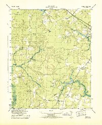
 1919 Homeville1919 Print · USGSCoastal Virginia during the late teens was defined by a landscape of river crossings and timbered swamplands along the Nottoway River. Genealogists and historians can trace family-named schools and vanished millponds, including Cabin Point School, Darden Millpond, and the settlement of Sebrell.
 - 1920 Map of Homeville
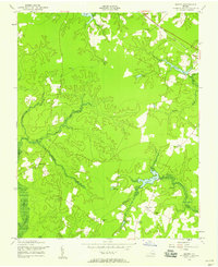
 1920 Homeville1920 Print · USGSCoastal plain life in Sussex and Southampton counties thrived along the rails and rivers in the early twentieth century. Researchers can trace the legacy of small communities and crossroads schools like Sebrell, Hickory Hill School, and the Union Hill Church near the Nottoway River.3 unique versions available
 - 1943 Map of Manry
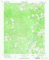
 1943 Manry1943 Print · USGSThe Sussex and Southampton county borderlands are shown here in the early 1940s, centered on rural farming communities and timbered swamps. Genealogists can trace family landmarks like Spiveys Store, the Grist Mill at Harriels Pond, and numerous sites like Burton Grove Church.
 - 1953 Map of Norfolk, 1954 Print
 1953 Norfolk1954 Print · USGSCoastal Virginia and northeastern North Carolina appear here during the post-war industrial boom, showing the critical rail-and-sea connections of Hampton Roads. Genealogists can trace family roots through rural landmarks like Gethsemane Ch, the Caledonia State Prison Farm, and the vast interior of the Dismal Swamp.4 unique versions available
 - 1956 Map of Manry, 1958 Print
 1956 Manry1958 Print · USGSCoastal plain farming and timberlands in Sussex and Southampton counties define the mid-century landscape. Genealogists and researchers can trace local congregations at Old Elam Church and Hebron Church, or locate family-named sites like Laniers Millpond.
 - 1969 Map of Manry, 1971 Print
 1969 Manry1971 Print · USGSThe Sussex and Southampton county borderlands come into focus in the late sixties, showcasing a landscape of lowland swamps and rural crossroads. Genealogists and local historians can trace family-named landmarks like Barrett Corner, Laniers Millpond, and Hebron Ch.
 - 1984 Map of Emporia, 1986 Print
 1984 Emporia1986 Print · USGSSouthside Virginia and the North Carolina borderlands are captured here in the mid-1980s, centered on the transit hub of Emporia. Researchers can trace old rail corridors like the Seaboard System or locate historic sites including Fort Christanna and White Oak Ch.
 - 1990 Map of Emporia
 1990 Emporia1990 Print · USGSThe Southside Virginia borderlands are captured here in the late twentieth century, showing the critical rail and river networks of the region. Genealogists and local historians can trace family roots through rural communities like Alberta, Boykins, and Dolphin along the Meherrin River.
End of results
Showing maps 1-8 of 8
Top cities near Piney Grove
- Waverly historical maps
- Wakefield historical maps
- Sedley historical maps
- Ivor historical maps
- Dendron historical maps
- Surry historical maps
Frequently asked questions
- What are the different types of historical maps available for Piney Grove?
- What is the oldest map of Piney Grove?
- Where can I purchase historical maps of Piney Grove for my home or office?
- Where can I download high-res historical maps of Piney Grove?
- Are there historical topographic maps available for Piney Grove?
- Is there historical aerial imagery available for Piney Grove?
- Where are historical maps of Piney Grove sourced from?