1940s Maps of Currioman Landing, Virginia
Explore 3 historic maps of Currioman Landing from the 1940s. These maps offer a rare glimpse into what life looked like during the 1940s — showing old roads, neighborhoods, homes, and landmarks that have changed or disappeared over time.
Whether you're researching your family's past, planning a metal detecting trip, or studying how Currioman Landing's landscape evolved across the 1940s, these high-resolution maps are a powerful tool for exploring the history of this region.
- Focus on a specific era: All maps on this page are from the 1940s, giving you a focused view of this time period.
- See what’s changed: Compare century-old streets, trails, and buildings to today's modern landscape using overlays and satellite layers.
- Research with precision: Use these maps for genealogy, historical research, land use analysis, or educational projects.
- View, download, or print: Maps are fully viewable online in high resolution, and can be downloaded or printed for your own records.
Start exploring Currioman Landing's history through authentic maps from the 1940s. This is your window into the past.
Currioman Landing, VA maps
(3)- 1943 Map of Stratford
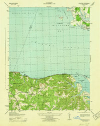 1943 Stratford1943 Print · USGSMaryland and Virginia shorelines meet along the Potomac River in the early 1940s, highlighting the historic grounds of Stratford Hall. Genealogists and local historians can trace family-named sites like Goodrich Farm, Currioman Farm, and the riverside community of Colton.
 - 1946 Map of Stratford, 1952 Print
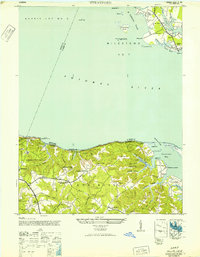 1946 Stratford1952 Print · USGSThe Potomac River divides Maryland and Virginia in the mid-1940s, revealing a landscape of historic plantations and river landings. Researchers can trace the grounds of Stratford Hall or locate vanished sites like Hill School and Mt Airy Wharf.
 - 1948 Map of Washington
 1948 Washington1948 Print · USGSThe Potomac and Chesapeake regions in the late 1940s reveal a landscape of expanding military reach and deep-rooted Tidewater settlements. Trace old rail corridors like the Richmond Fredericksburg & Potomac RR or locate landmarks like the Wakefield Washington Monument and St. Marys College.2 unique versions available
End of results
Showing maps 1-3 of 3
Top cities near Currioman Landing
- Lexington Park historical maps
- Wildewood historical maps
- Colonial Beach historical maps
- Leonardtown historical maps
- Tappahannock historical maps
- Warsaw historical maps
See more
Frequently asked questions
- What are the different types of historical maps available for Currioman Landing?
- What is the oldest map of Currioman Landing?
- Where can I purchase historical maps of Currioman Landing for my home or office?
- Where can I download high-res historical maps of Currioman Landing?
- Are there historical topographic maps available for Currioman Landing?
- Is there historical aerial imagery available for Currioman Landing?
- Where are historical maps of Currioman Landing sourced from?