1960s Maps of Wythe County, Virginia
Explore 15 historic maps of Wythe County from the 1960s. These maps offer a rare glimpse into what life looked like during the 1960s — showing old roads, neighborhoods, homes, and landmarks that have changed or disappeared over time.
Whether you're researching your family's past, planning a metal detecting trip, or studying how Wythe County's landscape evolved across the 1960s, these high-resolution maps are a powerful tool for exploring the history of this region.
- Focus on a specific era: All maps on this page are from the 1960s, giving you a focused view of this time period.
- See what’s changed: Compare century-old streets, trails, and buildings to today's modern landscape using overlays and satellite layers.
- Research with precision: Use these maps for genealogy, historical research, land use analysis, or educational projects.
- View, download, or print: Maps are fully viewable online in high resolution, and can be downloaded or printed for your own records.
Start exploring Wythe County's history through authentic maps from the 1960s. This is your window into the past.
Wythe County, VA maps
(15)- 1961 Map of Bluefield
 1961 Bluefield1961 Print · USGSThe coalfields and mountain ridges of southern West Virginia and southwest Virginia are captured in the early sixties. Genealogists can trace family ties through rail-linked towns like Princeton and Richlands or along the shores of Bluestone Reservoir.
 - 1962 Map of Winston-Salem
 1962 Winston-Salem1962 Print · USGSThe North Carolina Piedmont meets the Virginia highlands in the early sixties, showing the rail corridors and mountain gaps of the southern Appalachians. Researchers can trace the Blue Ridge Parkway or locate family sites near Winston-Salem, Mount Airy, and Hanging Rock Mountain.
 - 1965 Map of Austinville, 1966 Print
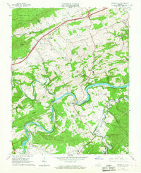
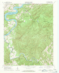
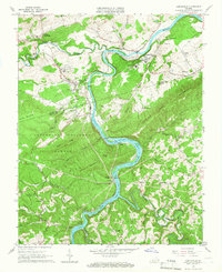 1965 Austinville1966 Print · USGSThe New River valley and its mining corridor are captured here in the mid-sixties as industry and rural life converged. Genealogists and historians can trace family roots at Bakers Chapel, locate the Van Mater Shaft mines, or follow the old Norfolk and Western line.3 unique versions available
 - 1965 Map of Long Spur, 1967 Print
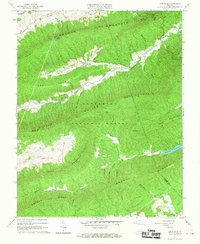 1965 Long Spur1967 Print · USGSThe mountain valleys of Wythe and Pulaski counties are captured here in the mid-1960s as rural life persisted along the ridges. Genealogists and hikers can trace the Appalachian Trail across Walker Mountain or locate the old Spur Branch Sch and Davis Ch near Long Spur.3 unique versions available
 - 1965 Map of Pulaski, 1967 Print
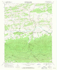
 1965 Pulaski1967 Print · USGSPulaski was a thriving rail and mountain hub during the mid-sixties, situated at the edge of the Jefferson National Forest. Researchers can trace the town's growth through landmarks like Calfee Park, the Empire Mine, and the Norfolk and Western rail network.4 unique versions available
 - 1965 Map of Sylvatus, 1967 Print
 1965 Sylvatus1967 Print · USGSCarroll and Wythe counties are captured in the mid-sixties, showing the mountainous terrain just as interstate transit began to change the rural landscape. Genealogists and local historians can locate Jackson Ferry, the Old Shot Tower, and numerous small landmarks like Beasley Hill Cem.3 unique versions available
 - 1965 Map of Fosters Falls, 1967 Print
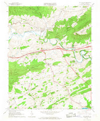
 1965 Fosters Falls1967 Print · USGSThe New River valley at the mid-century mark reveals a landscape defined by the Norfolk and Western railroad and the iron-industry legacy of Fosters Falls. Genealogists and industrial historians can trace rural life through landmarks like Boom Furnace, Oglesby Cem, and High Rocks Mill.3 unique versions available
 - 1965 Map of Max Meadows, 1968 Print
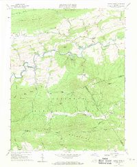
 1965 Max Meadows1968 Print · USGSVirginia's Wythe County landscape is shown in the mid-1960s as a mix of traditional Appalachian industry and modern development. Trace family roots and local landmarks from Walton Furnace and Grahams Forge to the Fort Chiswell High Sch and Max Meadows.4 unique versions available
 - 1968 Map of Wytheville, 1970 Print
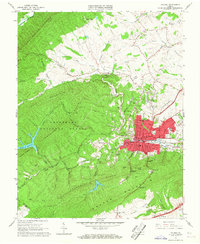
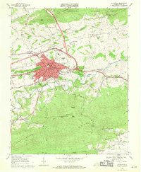 1968 Wytheville1970 Print · USGSWytheville and the surrounding Wythe County highlands are captured here during a period of significant transit growth in the late sixties. Researchers can trace local genealogy and industry through landmarks like Stones Mill, the Wytheville Sanitarium and Hospital, and several rural sanctuaries including Fellowship Ch.4 unique versions available
 - 1968 Map of Crockett, 1971 Print
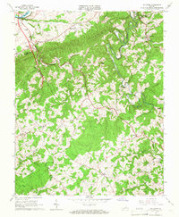
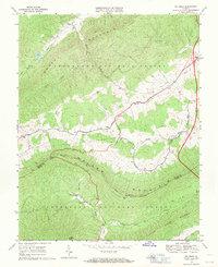
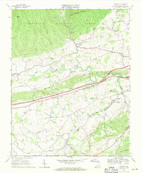 1968 Crockett1971 Print · USGSWythe County, Virginia, is captured here in the late sixties as modern highway infrastructure begins to bisect traditional valley settlements. Researchers can trace family roots at St Pauls Ch and Kings Grove Ch or explore the rail-side operations at Groseclose and Government Siding.3 unique versions available
 - 1968 Map of Hiwassee, 1971 Print
 1968 Hiwassee1971 Print · USGSPulaski and Carroll counties appear here in the late sixties, where the mountain terrain meets the rising waters of the New River valley. Researchers can trace the rail corridor through Hiwassee or find local landmarks like Bethel Ch and Tinytown.2 unique versions available
 - 1968 Map of Speedwell, 1971 Print
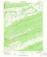
 1968 Speedwell1971 Print · USGSThe mountain valleys of Wythe County come into focus during the late sixties as the area maintained its traditional rural character. Researchers can trace the Old Railroad Grade and locate long-standing community centers such as Stroupes Store, Zion Ch, and Speedwell.2 unique versions available
 - 1968 Map of Bland, 1971 Print
 1968 Bland1971 Print · USGSThe ridges and valleys of Bland County are captured here in the late sixties as the mountain communities remained centered around old churches and mills. Genealogists and hikers can trace the Appalachian Trail across Walker Mountain or locate Temple Hill Cem and Helveys Mill.3 unique versions available
 - 1968 Map of Big Bend, 1971 Print
 1968 Big Bend1971 Print · USGSBland and Wythe counties are shown in the late sixties as the mountain ridges remained largely forest and the valleys supported quiet rural life. Genealogists can locate several local landmarks including Community Ch, Effna, and Stony Fork Ch.2 unique versions available
 - 1968 Map of Cripple Creek, 1971 Print
 1968 Cripple Creek1971 Print · USGSCripple Creek and the northern ridges of the Jefferson National Forest are captured here in the late sixties as the region's industrial relics began to fade. Genealogists and historians can trace family sites at Davis Cem, old congregations like Bethany Ch, and industrial ruins at Eagle Furnace.2 unique versions available
End of results
Showing maps 1-15 of 15
Top cities of Wythe County
- Wytheville historical maps
- Rural Retreat historical maps
- Fort Chiswell historical maps
- Max Meadows historical maps
- Ivanhoe historical maps
- Austinville historical maps
Frequently asked questions
- What are the different types of historical maps available for Wythe County?
- What is the oldest map of Wythe County?
- Where can I purchase historical maps of Wythe County for my home or office?
- Where can I download high-res historical maps of Wythe County?
- Are there historical topographic maps available for Wythe County?
- Is there historical aerial imagery available for Wythe County?
- Where are historical maps of Wythe County sourced from?