1930s Maps of Wythe County, Virginia
Explore 10 historic maps of Wythe County from the 1930s. These maps offer a rare glimpse into what life looked like during the 1930s — showing old roads, neighborhoods, homes, and landmarks that have changed or disappeared over time.
Whether you're researching your family's past, planning a metal detecting trip, or studying how Wythe County's landscape evolved across the 1930s, these high-resolution maps are a powerful tool for exploring the history of this region.
- Focus on a specific era: All maps on this page are from the 1930s, giving you a focused view of this time period.
- See what’s changed: Compare century-old streets, trails, and buildings to today's modern landscape using overlays and satellite layers.
- Research with precision: Use these maps for genealogy, historical research, land use analysis, or educational projects.
- View, download, or print: Maps are fully viewable online in high resolution, and can be downloaded or printed for your own records.
Start exploring Wythe County's history through authentic maps from the 1930s. This is your window into the past.
Wythe County, VA maps
(10)- 1930 Map of Speedwell
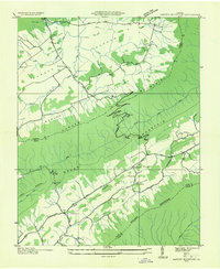
 1930 Speedwell1930 Print · USGSWythe County is captured here in the late twenties, showing the intersection of vital transit corridors and mountain wilderness. Researchers can trace the early Appalachian Trail or locate family roots at St Paul Ch and Slate Spring Sch.
 - 1930 Map of Max Meadows
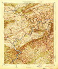 1930 Max Meadows1930 Print · USGSThe industrial and riverine corridor of Wythe and Carroll counties comes alive in the late 1920s, showcasing a network of mining towns and rail lines. Trace family roots and local history through landmarks like Fort Chiswell, the Boom Furnace, and the ferry crossing at Carter Ferry.3 unique versions available
 - 1931 Map of Rural Retreat
 1931 Rural Retreat1931 Print · USGSSouthwestern Virginia in the early 1930s is defined by its ridge-and-valley terrain and the rail-and-road corridor of the Norfolk and Western. Genealogists can trace local landmarks like Wasson Cem, Roberts Mill, and the Old Iron Mine near Sugar Grove.
 - 1934 Map of Pulaski
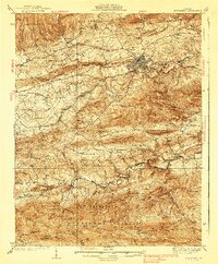
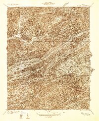 1934 Pulaski1934 Print · USGSPulaski and the surrounding Appalachian ridges are captured here during the mid-1930s, showing the intersection of mountain geography and local industry. Researchers can trace rural life through sites like the Stanse Mines, the Brick Church, and several valley schoolhouses including Long Spur Sch.
 - 1935 Map of Nebo
 1935 Nebo1935 Print · USGSSmyth County mountain valleys and the Holston River are mapped here in the mid-1930s. Genealogists can locate family landmarks like Tilson Mill, Groseclose Store, and rural schoolhouses including Nebo Sch.
 - 1935 Map of Cedar Springs
 1935 Cedar Springs1935 Print · USGSSouthwest Virginia's high ridges and hollows come into focus during the mid-1930s as the Smyth and Wythe county line is surveyed. Researchers can trace the exact locations of local landmarks like Lindamood Sch, Union Chapel, and the paths through Glade Hollow.
 - 1935 Map of Garden Mountain
 1935 Garden Mountain1935 Print · USGSBland County highland valleys are captured in the mid-1930s as the Tennessee Valley Authority surveyed these mountain gaps. Genealogists can locate family homes and community centers near Sharon Springs, Little Town, and Red Oak Sch along the North Fork Holston River.
 - 1935 Map of Groseclose
 1935 Groseclose1935 Print · USGSWythe County, Virginia, is captured in the mid-1930s along the vital Holston River transportation corridor. Genealogists and local historians can trace family land near Groseclose and Old Mt Airy, or locate community centers like Bethany Ch and Murpheyville Sch.
 - 1936 Map of Burkes Garden
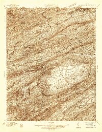 1936 Burkes Garden1936 Print · USGSTazewell and Bland Counties appear in the mid-1930s, defined by the extraordinary limestone bowl of Burkes Garden. Genealogists and historians can trace family locations near Maple Hill Cem, the Witten Mill settlement, and the industrial corridor at Bluefield.
 - 1939 Map of Speedwell
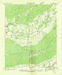
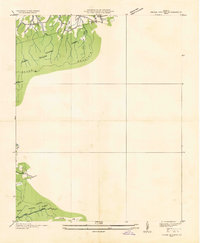
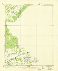
 1939 Speedwell1939 Print · USGSThe mountain valleys of Wythe County are captured here in the late 1930s, showing a landscape of scattered rural schools and early industrial sites. Genealogists can locate family landmarks like Rowe Crossroads or trace the early path of the APPALACHIAN TRAILS past Little Wythe Furnace.3 unique versions available
End of results
Showing maps 1-10 of 10
Top cities of Wythe County
- Wytheville historical maps
- Rural Retreat historical maps
- Fort Chiswell historical maps
- Max Meadows historical maps
- Ivanhoe historical maps
- Austinville historical maps
Frequently asked questions
- What are the different types of historical maps available for Wythe County?
- What is the oldest map of Wythe County?
- Where can I purchase historical maps of Wythe County for my home or office?
- Where can I download high-res historical maps of Wythe County?
- Are there historical topographic maps available for Wythe County?
- Is there historical aerial imagery available for Wythe County?
- Where are historical maps of Wythe County sourced from?