1910s Maps of Port Angeles, Washington
Explore 2 historic maps of Port Angeles from the 1910s. These maps offer a rare glimpse into what life looked like during the 1910s — showing old roads, neighborhoods, homes, and landmarks that have changed or disappeared over time.
Whether you're researching your family's past, planning a metal detecting trip, or studying how Port Angeles's landscape evolved across the 1910s, these high-resolution maps are a powerful tool for exploring the history of this region.
- Focus on a specific era: All maps on this page are from the 1910s, giving you a focused view of this time period.
- See what’s changed: Compare century-old streets, trails, and buildings to today's modern landscape using overlays and satellite layers.
- Research with precision: Use these maps for genealogy, historical research, land use analysis, or educational projects.
- View, download, or print: Maps are fully viewable online in high resolution, and can be downloaded or printed for your own records.
Start exploring Port Angeles's history through authentic maps from the 1910s. This is your window into the past.
Port Angeles, WA maps
(2)- 1918 Map of Port Angeles
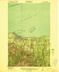 1918 Port Angeles1918 Print · USGSThe northern Olympic Peninsula comes to life in the years following the Great War, showing a landscape defined by maritime trade and logging. Genealogists and historians can locate early landmarks like Reeveton, the Ennis Creek Ranger Station, and several rural schools including Fairview School.4 unique versions available
 - 1919 Map of Port Crescent
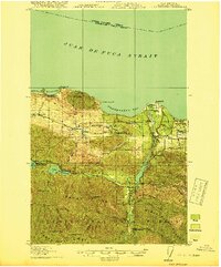 1919 Port Crescent1919 Print · USGSThe northern Olympic Peninsula comes alive in this survey, showing the shoreline from Agate Bay to Freshwater Bay. Trace the early timber economy through the Logging RR and find vanished sites like Port Crescent or the East Beach ferry landing.4 unique versions available
End of results
Showing maps 1-2 of 2
Top neighborhoods of Port Angeles
- Pine Hill Neighborhood historical maps
- Harbor View Neighborhood historical maps
- Lincoln Park Neighborhood historical maps
Frequently asked questions
- What are the different types of historical maps available for Port Angeles?
- What is the oldest map of Port Angeles?
- Where can I purchase historical maps of Port Angeles for my home or office?
- Where can I download high-res historical maps of Port Angeles?
- Are there historical topographic maps available for Port Angeles?
- Is there historical aerial imagery available for Port Angeles?
- Where are historical maps of Port Angeles sourced from?