1980s Maps of US Coast Guard Reservation, Washington
Explore 3 historic maps of US Coast Guard Reservation from the 1980s. These maps offer a rare glimpse into what life looked like during the 1980s — showing old roads, neighborhoods, homes, and landmarks that have changed or disappeared over time.
Whether you're researching your family's past, planning a metal detecting trip, or studying how US Coast Guard Reservation's landscape evolved across the 1980s, these high-resolution maps are a powerful tool for exploring the history of this region.
- Focus on a specific era: All maps on this page are from the 1980s, giving you a focused view of this time period.
- See what’s changed: Compare century-old streets, trails, and buildings to today's modern landscape using overlays and satellite layers.
- Research with precision: Use these maps for genealogy, historical research, land use analysis, or educational projects.
- View, download, or print: Maps are fully viewable online in high resolution, and can be downloaded or printed for your own records.
Start exploring US Coast Guard Reservation's history through authentic maps from the 1980s. This is your window into the past.
US Coast Guard Reservation, WA maps
(3)- 1984 Map of Clallam Bay
 1984 Clallam Bay1984 Print · USGSCoastal life in the mid-1980s along the Olympic Peninsula is centered on the maritime settlements of Sekiu and Clallam Bay. Researchers can trace the river systems of the Hoko River and find landmarks like Slip Point and the Sekiu Airport.
 - 1984 Map of Slip Point
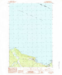
 1984 Slip Point1984 Print · USGSThe maritime boundary between Washington and British Columbia stretches across the water in this mid-eighties survey of the Olympic Peninsula coast. You can trace the shoreline at Slip Point, finding the Slip Point Lighthouse and the Clallam River mouth.
 - 1986 Map of Cape Flattery, 1987 Print
 1986 Cape Flattery1987 Print · USGSThe tip of the Olympic Peninsula and the waters of the Strait of Juan de Fuca are captured here in the mid-eighties. Researchers can trace tribal lands like the Makah Indian Reservation, the remote Old Royal settlement, and maritime landmarks like Cemetery Point.
End of results
Showing maps 1-3 of 3
Top cities near US Coast Guard Reservation
Frequently asked questions
- What are the different types of historical maps available for US Coast Guard Reservation?
- What is the oldest map of US Coast Guard Reservation?
- Where can I purchase historical maps of US Coast Guard Reservation for my home or office?
- Where can I download high-res historical maps of US Coast Guard Reservation?
- Are there historical topographic maps available for US Coast Guard Reservation?
- Is there historical aerial imagery available for US Coast Guard Reservation?
- Where are historical maps of US Coast Guard Reservation sourced from?