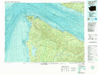
1986 Map of Cape Flattery
USGS Topo · Published 1987About this map
Makah Indian Reservation anchors the northwestern tip of the Olympic Peninsula, where the Strait of Juan de Fuca meets the Pacific Ocean. This 1980s topographic-bathymetric study captures a landscape defined by coastal industry and federal land management, featuring the Makah National Salmon Hatchery and the Makah Air Force Station near Neah Bay. Farther south, the inland geography is dominated by the Soleduck Valley and the expansive waters of Ozette Lake, surrounded by the protected boundaries of Olympic National Park.
Find a feature on this map
100 named features on this map. Tap any name to fly to it.
Don’t see what you’re looking for? This feature index may not catch every label — zoom into the map to look around manually.
Map Details
Editions of this 1986 Cape Flattery Map
This is the sole edition of this map. No revisions or reprints were ever made.
Other maps of this area

1918 · Lake Crescent
USGS Topo · 1:62,500

1922 · Pysht
USGS Topo · 1:62,500

1922 · Lake Crescent
USGS Topo · 1:62,500

1935 · Clallam
USGS Topo · 1:62,500

1935 · Ozette Lake
USGS Topo · 1:62,500

1935 · Lake Pleasant
USGS Topo · 1:62,500

1938 · Cape Flattery
USGS Topo · 1:62,500

1939 · Forks
USGS Topo · 1:62,500

1939 · Mount Tom
USGS Topo · 1:62,500

1942 · Pysht
USGS Topo · 1:62,500