1990s Maps of Camas, Washington
Explore 3 historic maps of Camas from the 1990s. These maps offer a rare glimpse into what life looked like during the 1990s — showing old roads, neighborhoods, homes, and landmarks that have changed or disappeared over time.
Whether you're researching your family's past, planning a metal detecting trip, or studying how Camas's landscape evolved across the 1990s, these high-resolution maps are a powerful tool for exploring the history of this region.
- Focus on a specific era: All maps on this page are from the 1990s, giving you a focused view of this time period.
- See what’s changed: Compare century-old streets, trails, and buildings to today's modern landscape using overlays and satellite layers.
- Research with precision: Use these maps for genealogy, historical research, land use analysis, or educational projects.
- View, download, or print: Maps are fully viewable online in high resolution, and can be downloaded or printed for your own records.
Start exploring Camas's history through authentic maps from the 1990s. This is your window into the past.
Camas, WA maps
(3)- 1990 Map of Lacamas Creek, 1995 Print
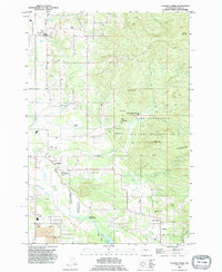 1990 Lacamas Creek1995 Print · USGSNortheast of Vancouver in the early nineties, this area shows a landscape defined by military land and rural crossroads. Genealogists and researchers can trace local landmarks from Hockinson and Fern Prairie to industrial sites like the English Pit and Grove Field.
 - 1993 Map of Camas, 1996 Print
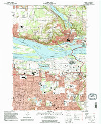 1993 Camas1996 Print · USGSThe Columbia River corridor in the 1990s reveals a bustling landscape of industry and suburban growth spanning the Washington and Oregon border. Genealogists and researchers can trace the development of Camas and Gresham, locating landmarks like Knight Cem, the Aluminum Plant, and Mount Hood Community College.
 - 1994 Map of Washougal, 1996 Print
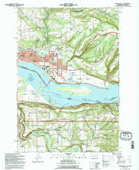 1994 Washougal1996 Print · USGSThe Columbia River corridor comes into focus in the mid-1990s as it divides Washington and Oregon. Researchers can trace local landmarks like Washougal Memorial Cemetery, the Grange Hall, and Corbett Station.
End of results
Showing maps 1-3 of 3
Top cities near Camas
- Portland historical maps
- Vancouver historical maps
- Gresham historical maps
- Lake Oswego historical maps
- West Linn historical maps
- Happy Valley historical maps
See more
Top neighborhoods of Camas
Frequently asked questions
- What are the different types of historical maps available for Camas?
- What is the oldest map of Camas?
- Where can I purchase historical maps of Camas for my home or office?
- Where can I download high-res historical maps of Camas?
- Are there historical topographic maps available for Camas?
- Is there historical aerial imagery available for Camas?
- Where are historical maps of Camas sourced from?