1970s Maps of Connell, Washington
Explore 3 historic maps of Connell from the 1970s. These maps offer a rare glimpse into what life looked like during the 1970s — showing old roads, neighborhoods, homes, and landmarks that have changed or disappeared over time.
Whether you're researching your family's past, planning a metal detecting trip, or studying how Connell's landscape evolved across the 1970s, these high-resolution maps are a powerful tool for exploring the history of this region.
- Focus on a specific era: All maps on this page are from the 1970s, giving you a focused view of this time period.
- See what’s changed: Compare century-old streets, trails, and buildings to today's modern landscape using overlays and satellite layers.
- Research with precision: Use these maps for genealogy, historical research, land use analysis, or educational projects.
- View, download, or print: Maps are fully viewable online in high resolution, and can be downloaded or printed for your own records.
Start exploring Connell's history through authentic maps from the 1970s. This is your window into the past.
Connell, WA maps
(3)- 1970 Map of Frischknecht, 1973 Print
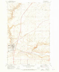
 1970 Frischknecht1973 Print · USGSFranklin County grain-growing country comes into focus in the early 1970s, as the rail and road network supported the region's agricultural harvest. Genealogists and historians can trace the Burlington Northern line to the Grain Elevators at Frischknecht and locate the Paradise Flats Cem.
 - 1970 Map of Connell SE, 1973 Print
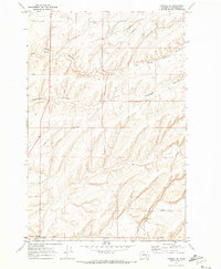 1970 Connell SE1973 Print · USGSFranklin County's coulee-scarred plains are captured here in the early 1970s, illustrating the agricultural and infrastructural network of eastern Washington. Researchers can trace family-named routes like Bauermeister Road and find landmarks such as McLean and Five Corners.
 - 1970 Map of Connell, 1973 Print
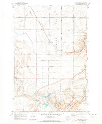
 1970 Connell1973 Print · USGSFranklin County's rail and agricultural heart is captured here during the early seventies as the region's transport network matured. Researchers can trace the path of the Northern Pacific railroad through Connell or locate family-named landmarks like Myers Road and Nordheim.
End of results
Showing maps 1-3 of 3
Top cities near Connell
Frequently asked questions
- What are the different types of historical maps available for Connell?
- What is the oldest map of Connell?
- Where can I purchase historical maps of Connell for my home or office?
- Where can I download high-res historical maps of Connell?
- Are there historical topographic maps available for Connell?
- Is there historical aerial imagery available for Connell?
- Where are historical maps of Connell sourced from?