1980s Maps of Soap Lake, Washington
Explore 2 historic maps of Soap Lake from the 1980s. These maps offer a rare glimpse into what life looked like during the 1980s — showing old roads, neighborhoods, homes, and landmarks that have changed or disappeared over time.
Whether you're researching your family's past, planning a metal detecting trip, or studying how Soap Lake's landscape evolved across the 1980s, these high-resolution maps are a powerful tool for exploring the history of this region.
- Focus on a specific era: All maps on this page are from the 1980s, giving you a focused view of this time period.
- See what’s changed: Compare century-old streets, trails, and buildings to today's modern landscape using overlays and satellite layers.
- Research with precision: Use these maps for genealogy, historical research, land use analysis, or educational projects.
- View, download, or print: Maps are fully viewable online in high resolution, and can be downloaded or printed for your own records.
Start exploring Soap Lake's history through authentic maps from the 1980s. This is your window into the past.
Soap Lake, WA maps
(2)- 1982 Map of Moses Lake, 1983 Print
 1982 Moses Lake1983 Print · USGSThe Columbia Basin during the early eighties shows a landscape transformed by large-scale irrigation and military aviation. Researchers can trace the development of Larson Air Force Base or locate vanished rail stops along the Burlington Northern near Ephrata and Quincy.2 unique versions available
 - 1986 Map of Little Soap Lake
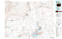
 1986 Little Soap Lake1986 Print · USGSThe alkaline lake basins of central Washington are captured here in the 1980s as the town of Soap Lake continued to grow. Researchers can locate distinct geological and cultural sites including Horsethief Cave, Pate Spring, and the Lake Lenore shoreline.
End of results
Showing maps 1-2 of 2
Top cities near Soap Lake
Top neighborhoods of Soap Lake
Frequently asked questions
- What are the different types of historical maps available for Soap Lake?
- What is the oldest map of Soap Lake?
- Where can I purchase historical maps of Soap Lake for my home or office?
- Where can I download high-res historical maps of Soap Lake?
- Are there historical topographic maps available for Soap Lake?
- Is there historical aerial imagery available for Soap Lake?
- Where are historical maps of Soap Lake sourced from?