1900s (20th Century) Maps of Warden, Washington
Explore 6 historic maps of Warden from the 1900s (20th Century). These maps offer a rare glimpse into what life looked like during the 1900s — showing old roads, neighborhoods, homes, and landmarks that have changed or disappeared over time.
Whether you're researching your family's past, planning a metal detecting trip, or studying how Warden's landscape evolved across the 1900s, these high-resolution maps are a powerful tool for exploring the history of this region.
- Focus on a specific era: All maps on this page are from the 1900s, giving you a focused view of this time period.
- See what’s changed: Compare century-old streets, trails, and buildings to today's modern landscape using overlays and satellite layers.
- Research with precision: Use these maps for genealogy, historical research, land use analysis, or educational projects.
- View, download, or print: Maps are fully viewable online in high resolution, and can be downloaded or printed for your own records.
Start exploring Warden's history through authentic maps from the 1900s. This is your window into the past.
Warden, WA maps
(6)- 1924 Map of Othello
 1924 Othello1924 Print · USGSThe Columbia Basin during the mid-1920s shows a landscape of pioneering rail towns and remote schoolhouses. Genealogists and historians can trace family locations through rural landmarks like ADAMS CEM, Billington School, and the rail stops at Bruce and Hamlet Spur.2 unique versions available
 - 1953 Map of Walla Walla, 1964 Print
 1953 Walla Walla1964 Print · USGSSoutheast Washington enters the atomic and hydroelectric age in the mid-twentieth century as new dams reshape the desert landscape. You can trace the development of the Hanford Works, identify remote rail stops like Novara Siding, and locate the historic Dry Creek Cem.3 unique versions available
 - 1954 Map of Warden, 1956 Print
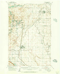
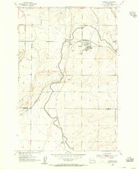 1954 Warden1956 Print · USGSWarden and the surrounding Columbia Basin are shown in the mid-1950s, highlighting the massive arrival of irrigation and rail infrastructure. Trace the dual railroad lines of the Northern Pacific and trace the path of the East Low Canal as it passes West Warden.2 unique versions available
 - 1954 Map of Othello, 1956 Print
 1954 Othello1956 Print · USGSThe Columbia Basin is seen mid-century as irrigation projects transformed the landscape around Othello and Warden. Researchers can trace the development of the Potholes East Canal alongside local landmarks like Lutacaga Sch and the Adams Cem.
 - 1958 Map of Walla Walla
 1958 Walla Walla1958 Print · USGSThe Tri-Cities and Walla Walla region are captured here during the mid-century expansion of atomic energy and river infrastructure. Genealogists and historians can trace the early layout of Richland (AEC), the rural Hatton and Washtucna settlements, and landmarks like Palouse Falls State Park.
 - 1979 Map of Priest Rapids
 1979 Priest Rapids1979 Print · USGSThe Columbia River basin in the late seventies reveals a landscape shaped by massive federal projects and rail expansion. Trace the Hanford Works perimeter, the Priest Rapids Dam, and the early growth of Royal City and Othello.2 unique versions available
End of results
Showing maps 1-6 of 6
Top cities near Warden
Frequently asked questions
- What are the different types of historical maps available for Warden?
- What is the oldest map of Warden?
- Where can I purchase historical maps of Warden for my home or office?
- Where can I download high-res historical maps of Warden?
- Are there historical topographic maps available for Warden?
- Is there historical aerial imagery available for Warden?
- Where are historical maps of Warden sourced from?