1990s Maps of Aberdeen, Washington
Explore 3 historic maps of Aberdeen from the 1990s. These maps offer a rare glimpse into what life looked like during the 1990s — showing old roads, neighborhoods, homes, and landmarks that have changed or disappeared over time.
Whether you're researching your family's past, planning a metal detecting trip, or studying how Aberdeen's landscape evolved across the 1990s, these high-resolution maps are a powerful tool for exploring the history of this region.
- Focus on a specific era: All maps on this page are from the 1990s, giving you a focused view of this time period.
- See what’s changed: Compare century-old streets, trails, and buildings to today's modern landscape using overlays and satellite layers.
- Research with precision: Use these maps for genealogy, historical research, land use analysis, or educational projects.
- View, download, or print: Maps are fully viewable online in high resolution, and can be downloaded or printed for your own records.
Start exploring Aberdeen's history through authentic maps from the 1990s. This is your window into the past.
Aberdeen, WA maps
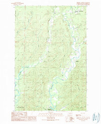
(3)- 1990 Map of Wynoochee Valley SW
 1990 Wynoochee Valley SW1990 Print · USGSThe Wynoochee and Wishkah river valleys in Grays Harbor County are shown here during the 1990s as a landscape of rural community and water management. Researchers can locate the Wynoochee Valley Grange Hall, the Diversion Dam, and the small settlement of Anderson.
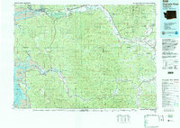
 - 1990 Map of Aberdeen Gardens
 1990 Aberdeen Gardens1990 Print · USGSThe river valleys north of Aberdeen are captured here in the early nineties, showing a landscape defined by timber and watershed management. Researchers can trace the Old Railroad Grade, locate the Cem at Wishkah, and explore the Olympic State Wildlife Area.
 - 1992 Map of Chehalis River, 1993 Print
 1992 Chehalis River1993 Print · USGSThe Chehalis River valley and the timberlands of the Black Hills are captured here in the early nineties. Researchers can trace rail-and-river history through Montesano and Raymond, or locate the unique Mima Mounds and Bordeaux.2 unique versions available
End of results
Showing maps 1-3 of 3
Top cities near Aberdeen
- Hoquiam historical maps
- Montesano historical maps
- Cosmopolis historical maps
- Aberdeen Gardens historical maps
Top neighborhoods of Aberdeen
- Pilgrim Heights historical maps
- Bel-Aire historical maps
- North Aberdeen historical maps
- South Aberdeen historical maps
Frequently asked questions
- What are the different types of historical maps available for Aberdeen?
- What is the oldest map of Aberdeen?
- Where can I purchase historical maps of Aberdeen for my home or office?
- Where can I download high-res historical maps of Aberdeen?
- Are there historical topographic maps available for Aberdeen?
- Is there historical aerial imagery available for Aberdeen?
- Where are historical maps of Aberdeen sourced from?