1940s Maps of Bay City, Washington
Explore 2 historic maps of Bay City from the 1940s. These maps offer a rare glimpse into what life looked like during the 1940s — showing old roads, neighborhoods, homes, and landmarks that have changed or disappeared over time.
Whether you're researching your family's past, planning a metal detecting trip, or studying how Bay City's landscape evolved across the 1940s, these high-resolution maps are a powerful tool for exploring the history of this region.
- Focus on a specific era: All maps on this page are from the 1940s, giving you a focused view of this time period.
- See what’s changed: Compare century-old streets, trails, and buildings to today's modern landscape using overlays and satellite layers.
- Research with precision: Use these maps for genealogy, historical research, land use analysis, or educational projects.
- View, download, or print: Maps are fully viewable online in high resolution, and can be downloaded or printed for your own records.
Start exploring Bay City's history through authentic maps from the 1940s. This is your window into the past.
Bay City, WA maps
(2)- 1941 Map of Grayland
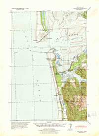 1941 Grayland1941 Print · USGSGrays Harbor and the Washington coast are captured here just before the mobilization of the early 1940s. Genealogists and historians can trace the foundations of Westport, locate the Western Logging Co Camp, and find maritime landmarks like the Grays Harbor L H.
 - 1943 Map of Copalis Beach
 1943 Copalis Beach1943 Print · USGSThe Washington coast in the 1940s is detailed here from the Olympic Peninsula to the Columbia River. Trace old beach settlements like Moclips and Copalis Beach alongside landmarks like the Willapa Bay Lighthouse.
End of results
Showing maps 1-2 of 2
Top cities near Bay City
- Aberdeen historical maps
- Hoquiam historical maps
- Ocean Shores historical maps
- Westport historical maps
- Grayland historical maps
- Ocean City historical maps
See more
Frequently asked questions
- What are the different types of historical maps available for Bay City?
- What is the oldest map of Bay City?
- Where can I purchase historical maps of Bay City for my home or office?
- Where can I download high-res historical maps of Bay City?
- Are there historical topographic maps available for Bay City?
- Is there historical aerial imagery available for Bay City?
- Where are historical maps of Bay City sourced from?