Old Maps of Grisdale, Washington for Hiking & Exploration
Hike through history with 7 historic maps of Grisdale. Explore old trails, ghost towns, and forgotten backroads — perfect for outdoor adventurers and local explorers.
- Rediscover forgotten places: Map out old mining camps, roads, and footpaths that no longer exist on modern maps.
- Layer with modern tools: Combine with LiDAR or satellite views to plan hikes through historical terrain.
- Made for exploration: Popular among hikers, overlanders, and local history lovers.
Use these maps to find adventure and explore the hidden past of Grisdale.
Grisdale, WA maps
(7)- 1921 Map of Satsop
 1921 Satsop1921 Print · USGSThe Olympic wilderness and early timber frontiers are documented here in the early twenties as logging infrastructure moved into the river valleys. Researchers can trace the Simpson Logging R.R. and locate the original Wynoochee RS station.
 - 1955 Map of Grisdale, 1957 Print
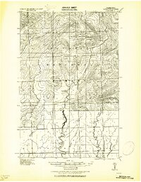
 1955 Grisdale1957 Print · USGSGrays Harbor and Mason counties are shown during the height of mid-century timber operations, centered on the logging community of Grisdale. Researchers can trace the extensive timber rail network, including the Schaefer Railroad and Anderson Logging RR, alongside landmarks like Satsop Guard Sta.4 unique versions available
 - 1958 Map of Seattle, 1966 Print
 1958 Seattle1966 Print · USGSThe Puget Sound region in the mid-fifties showcases a balance of urban growth and Olympic wilderness. Trace the industrial waterfronts of Tacoma, old naval facilities like Keyport Naval Res, and mountain peaks like Mount Constance.3 unique versions available
 - 1962 Map of Seattle
 1962 Seattle1962 Print · USGSThe Puget Sound region and Olympic Peninsula are shown at a peak of mid-century growth. Genealogists and historians can trace rail lines like the Pacific Coast RR or locate landmarks such as Fort Lawton and the Bothell Power Station.
 - 1988 Map of Shelton
 1988 Shelton1988 Print · USGSThe Olympic Peninsula's transition from high mountain wilderness to Puget Sound tideflats is captured here in the late eighties. Researchers can trace the path of the Logging Railroad or locate historical sites like Sanderson Field and the Skokomish Indian Reservation.
 - 1990 Map of Grisdale
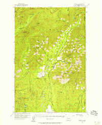
 1990 Grisdale1990 Print · USGSThe timberlands of the Olympic Peninsula are captured here in the 1990s as the logging community of Grisdale transitions. Genealogists and local historians can trace the drainages of the West Fork Satsop River and find landmarks like the Satsop FS Station and Weatherwax Ridge.
 - 2023 Map of Grisdale, 2023 Print
 2023 Grisdale2023 Print · USGSThe timberlands of Grays Harbor and Mason County are revealed in the early 2020s as a network of forest roads and river systems. Researchers can trace the West Fork Satsop River and its tributaries near Grisdale and find access points like the Upper Satsop Trailhead.
End of results
Showing maps 1-7 of 7
Frequently asked questions
- What are the different types of historical maps available for Grisdale?
- What is the oldest map of Grisdale?
- Where can I purchase historical maps of Grisdale for my home or office?
- Where can I download high-res historical maps of Grisdale?
- Are there historical topographic maps available for Grisdale?
- Is there historical aerial imagery available for Grisdale?
- Where are historical maps of Grisdale sourced from?